|
October  1ST 1250 A great gale and storm surge flooded England, Holland and Flanders causing extensive damage. (Ref. Wilson Wx. History) 1752 The second severe hurricane in two weeks hit the Carolinas. The Onslow County Courthouse was destroyed along with all its records, and Beacon Island disappeared. (David Ludlum) 1844 Through the 7th, a major hurricane swept over Jamaica, Cuba and Nassau and the Bahamas. According to early hurricane researcher William Redfield, the storm "exhibited an amount of injury and destruction such as is rarely known in the annals of commerce." 158 vessels were wrecked and 2,546 houses were destroyed along the- Cuban coast. (Ref. Wilson Wx. History) 1890 The U.S. Weather Bureau was established by an act of Congress, and assigned as part of the Department of Agriculture. Weather observations and forecasts were previously issued by the Army Signal Service. (Ref. Wilson Wx. History) 1893 The second great hurricane of the 1893 season hit the Mississippi Delta Region drowning more than 1000 persons. (David Ludlum) This compact hurricane became a major hurricane on October 1st, and early the next day, it became a Category 4 as it approached the Louisiana coast. On the morning of October 2, with a peak of 135 mph winds, the hurricane struck southeast Louisiana on the Louisiana mainland just west of Grand Isle. The storm continued to the northeast, weakening to a tropical storm over Alabama, and emerged into the Atlantic Ocean on the 4th then dissipated on the 5th. The surge was up to 16 feet, with heavy surf above it. The hurricane caused about 2000 fatalities in total, making it among the deadliest American hurricanes. (Ref. Wikipedia.org.) 1893 Hurricane Storm Track - Weather Underground 1954 On October 1st Boston, Massachusetts had a minimum temperature of 69 °F the warmest low temperature. This is also the highest minimum on Boston's records for October. (Ref. NOAA Boston Weather Events) 1976 A ridge of high pressure brought record highs to parts of the Midwest. Locations reporting their warmest October temperatures included: Hatfield, WI: 94°, Preston, MN: 92° (also latest occurrence of 90 in a year), Neillsville, WI: 92°, Caledonia, MN: 91°, and Jump River, WI: 87°. Other daily record highs included: La Crosse, WI: 92°, Des Moines, IA: 92°, Kansas City, MO: 92°, Madison, WI: 90 °F. (Ref. Wilson Wx. History) 1986 Heavy rainfall totals produced saturated soil conditions across parts of Oklahoma beginning the previous day. Conditions worsened across the area when more torrential rain fell during the first four days of October. Rainfall amounts of 6 to 10 inches were common, while 15 to 20 inch amounts were reported over north-central Oklahoma. The excessive rainfall caused most major rivers in the state to flood, requiring the evacuation of about 30,000 people from 25 towns. The floods destroyed 509 homes, damaged 3,957 others, and washed out many roads and bridges, including two bridges on I-35. (Ref. Wilson Wx. History) 1987 A blast of cold arctic air hit the north central U.S. An afternoon thunderstorm slackened the streets of Duluth, MN with hail and snow, and later in the afternoon, strong northerly winds reached 70 mph. Unseasonably warm weather continued in the Pacific Northwest. Afternoon highs of 90 degrees at Olympia WA, 92 degrees at Portland OR, and 89 degrees at Seattle WA, were records for the month of October. For Seattle WA it marked the twenty- first daily record high for the year, a record total in itself. (The National Weather Summary) 1988 Afternoon and evening thunderstorms produced severe weather across central Oklahoma and the eastern half of Texas. Thunderstorms in Texas produced softball size hail northwest of Nocona, and baseball size hail at Troy and Park Springs. (The National Weather Summary) (Storm Data) 1989 Thunderstorms produced severe weather in the southeastern U.S. through the daytime and evening hours. Severe thunderstorms spawned eleven tornadoes, with seven of those tornadoes in Georgia. A tornado southwest of Moultrie, GA killed two persons and injured a dozen others. Tornadoes also injured one person north of Graceville, FL, and two persons at Bartow, GA. (Storm Data) (The National Weather Summary) 1990 One inch of rain fell at Yuma, AZ in just 15 minutes. (Ref. AccWeather Weather History) 1992 A strong 588 decameter heat ridge extended from the Plains to the West Coast bringing record highs. Areas reporting their warmest October temperatures included: Sheridan, WY: 92° and Billings, MT: 90°-Tied. (Ref. Wilson - Additional Temperatures Listed On This Link) 1994 Lightning hit a bow-and-arrow deer hunter, knocking him down from his 15 feet high stand near Prosperity, PA. He survived, but experienced second degree burns along with blurred vision. (Ref. Weather Guide Calendar with Phenomenal Weather Events 2011 Accord Pub. 2010, USA) 1998 Heavy rain fell across the Liberal area in Kansas for 24 hours with the heaviest rain falling during the morning and afternoon hours. Five to eight inches were reported with one unofficial report indicating 10 inches. Streets were flooded that had never flooded before. A local disaster was declared. (Ref. Wilson Wx. History) 1999 A strong cold front with a Canadian blast and moisture combined to bring snow to parts of the upper Midwest. Caledonia, MN with 2 inches and La Crosse, WI with 0.3 of an inch had their earliest measurable snowfall. (Ref. Wilson Wx. History) 2006 An extended heat ridge brought record highs to parts of the Plains. Wichita, KS recorded their hottest October day ever with 97°. Other daily record highs included: Dodge City, KS: 96°-Tied, Lincoln, NE: 94°, Kansas City, MO: 94° and Sioux City, IA: 91°-Tied. (Ref. Wilson Wx. History) 2010 This October will be Nevada’s warmest with records going back to 1895. Today’s 94 °F in Winnemucca, 92° in Elko (previous record 89 °F on October 8, 1917), and 86 °F in Ely were all monthly records. For Elko, it was the first time in October the temperature had ever reached 90°F( impressive: records started in 1888). (Ref. Weather Guide Calendar with Phenomenal Weather Events 2012 Accord Pub. 2011, USA) |
|||||||||||||||||||||
|
October 2ND 1858 A hurricane with category 1 winds hit San Diego, CA, the only documented hurricane to strike California in history. This occurred before official weather observations began. Winds of at least 75 mph were estimated based on damage and journalistic accounts. Extensive wind damage to property neared F2 tornado scale damage. Streets were swept clean by heavy rains. (Ref. Wilson Wx. History) 1867 A hurricane struck Galveston, TX with a storm surge that produced $1 million dollars damage. (Ref. AccWeather Weather History) 1882 An early season windstorm over Oregon and northern California blew down thousands of trees and caused great crop damage in the Sacramento Valley. (David Ludlum) Louisiana was struck by major hurricane with winds reaching 100 mph and a 12-foot storm surge affecting the coast and bayous. 1,500 people were killed. (Ref. AccWeather Weather History) 1898 A hurricane of at least Category 3 intensity struck the Georgia coast washing away Campbell Island, killing 179 people. The storm was responsible for the highest storm surge on record in the northeast Florida and Southeast Georgia area. 1898 Georgia Hurricane Storm Track - Weather Underground 1899 Earliest frost @ WBO 33° and 4 consecutive dates rec. 1st - 4th. (Ref. Washington Weather Records - KDCA) Boston, Massachusetts had a trace of snow today for the earliest recorded snow for the city. (Ref. NOAA Boston Weather Events) 1951 The center of a Tropical Storm crossed Florida from near Fort Myers to Vero Beach. Rainfall totals ranged from 8 to 13 inches along the track, but no strong winds occurred near the center. The strong winds of 50 to 60 mph were all in squalls along the lower east coast and Keys, causing minor property damage. The greatest damage was from rains that flooded farms and pasture lands over a broad belt extending from Naples, Fort Myers, and Punta Gorda on the west coast to Stuart, Fort Pierce, and Vero Beach on the east. Roadways damaged and several bridges washed out. (Ref. Wilson Wx. History) 1953 An unseasonable heat ridge brought record heat from the Plains to the Appalachians. Several locations reported their warmest October temperatures on record including: Evansville, IN: 94°, St. Louis, MO: 94° (later tied), Springfield, IL: 93° (later tied), Louisville, KY: 92° (later tied then broken), Platteville, WI: 91°, Mondovi, WI: 90° and Duluth, MN: 86°. (Ref. Additional Temperatures Listed On This Link) 1959 A tornado struck the town of Ivy, VA (located near Charlottesville). Eleven persons were killed, including ten from one family. (The Weather Channel) 1963 Hurricane Flora moved across the south coast of Haiti and then meandered across eastern Cuba for the next 5 days, lashing the island with winds of 100 mph or more for at least 100 hours. Astronomical rainfall amounts as much as 90 inches were reported near Velasco. More rain was reported at Guantanamo Bay from Flora than was reported during the entire year of 1962. Flora remains the 2nd deadliest hurricane ever in the Atlantic, with over 7,000 deaths. (Ref. Wilson Wx. History) 1980 Several locations reported all-time October high temperature records including Palm Springs, CA: 116°, Borrego Springs, CA: 113 °F (This record was tied the next day), Yuma, AZ: 112°, Medford, OR: 99°, Eugene, OR: 94°, Blue Canyon, CA: 88° and Astoria, OR: 85°- since tied. (The Weather Channel) 1981 Severe thunderstorms raked Phoenix, AZ with heavy rain, high winds, and hail up to an inch and a half in diameter, for the second day in a row. Thunderstorms on the 1st deluged Phoenix with .68 inch of rain in five minutes, equaling their all-time record. (The Weather Channel) A city street in Prospect, CT was cratered by a lightning bolt that worked its way into buildings via a water main. Numerous water leaks resulted. (Ref. AccWeather Weather History) 1987 A fast moving cold front produced snow flurries from Minnesota to the Appalachian Mountains, and gale force winds behind the front ushered cold air into the Great Lakes Region. Valentine, NE reported a record low of 25 degrees. Temperatures recovered rapidly in the Northern High Plains Region, reaching the lower 80s by afternoon. Jackson, WY warmed from a morning low of 21 degrees to an afternoon high of 76 degrees. (The National Weather Summary) 1988 Early morning thunderstorms in Georgia produced three inches of rain at Canton and Woodstock. (The National Weather Summary) 1989 Flooding due to thunderstorm rains in the southeastern U.S. on the last day of September and the first day of October caused the Etowah River to rise seven feet above flood stage at Canton, GA. Thunderstorms produced up to ten inches of rain in northeastern Georgia, with six inches reported at Athens, GA in 24 hours. One man was killed, and another man was injured, when sucked by floodwaters into drainage lines. (The National Weather Summary) (Storm Data) 2000 Tremendous rains fell across South Florida due to a developing sub-tropical storm. Miami picked up 12.24 inches of rain in 24 hours and 15 inches in 2 days. The storm would go on to become Tropical Storm Leslie. On this date through the 3rd, while remaining nearly stationary off the coast, Hurricane Keith battered the Yucatan Peninsula and Belize with torrential rain. Keith dropped 32.67 inches at the Philip Goodson International Airport in Belize City. (Ref. Wilson Wx. History) (2nd-4th) 10.20 inches of rain fell (2nd-3rd) in a 10-mi-wide swath of FL’s Miami-Dade and extreme SE Broward counties. Approx. 93,000 homes and 214,000 people isolated by the resulting flooding; 2 men died when they drove their cars into canals. (Ref. Weather Guide Calendar with Phenomenal Weather Events 2011 Accord Pub. 2010, USA) 2003 Alaska: Temperatures around 70 °F in many Alaska communities set many all-time October maximum records by as much as 17 °F. In Chalkytsik, the high of 75 °F broke the old record by 16 F degrees. Other daily record highs included: Fort Yukon: 70°, Fairbanks: 70°, Homer: 60° and Bettles: 57 °F. (Ref. WxDoctor) 2015 Also see October 4th and Oct 5th for more about the flooding in SC. A Space Station View of The Cat 5 Hurricane that added to South Carolina Flooding (Ref. NOAA) |
|||||||||||||||||||||
|
October 3RD 1780 The hurricane season of 1780 was one of the worst in recorded history. At least 8 destructive storms struck American and Caribbean shores that year. In October, three storms in three successive weeks caused unparalleled economic and military destruction. The first, named the Savanna-La-Mer hurricane for the tiny settlement on the island of Jamaica which was completely destroyed by the storm's tides and winds, struck on this date. (Ref. AccWeather Weather History) 1841 An October gale, the worst of record for Nantucket, MA, caught the Cap Code fishing fleet at sea. Forty ships were driven ashore on Cape Cod, and 57 men perished from the town of Truro, MA alone. Heavy snow fell inland, with 18 inches near Middletown, CT. (David Ludlum) 1903 An F4 tornado moved northeast from west of Chatfield, MN, passing through and devastating St. Charles, MN. Seven people were killed and 30 injured as 50 homes and businesses were damaged or destroyed. Homes were also swept away in parts of Wisconsin, along Eagle Creek and then at Independence, where two people died and half of the town were torn apart. Damage for both states totaled $400,000 dollars. About two hours later, another F4 tornado apparently formed about 5 miles east of Rome and then moved east-northeast passing 1.5 miles south of Bancroft in Portage County. The tornado was up to a half mile wide but most of the damage was in Portage County. (Ref. Wilson Wx. History) 1912 The longest dry spell of record in the U.S. commenced as Bagdad, CA went 767 days without rain. (Ref. AccWeather Weather History) (David Ludlum) 1963 Hurricane Flora, one of the deadliest hurricanes on record in the Atlantic Basin, battered Haiti with sustained winds around 150 mph. The storm moved northwestward, meandered over western Cuba from the 4th to the 8th, and then finally accelerated northeastward out to sea. 5,000 people were killed on Haiti with damage severe to complete. Enormous amounts of rain fell in Cuba due to Flora's slow movement. 90 inches of rain deluged Bayamo. A total of 7,200 people were killed by Flora and damage was set at $435 million dollars. (Ref. Wilson Wx. History) 1964 Hurricane Hilda struck Louisiana spawning many tornadoes, and claimed twenty-two lives. Hurricane Hilda made landfall between Louisiana’s Point Au Fer and Marsh Island with sustained winds of 120 mph. High winds blew a full 40,000 gallon water tank (on a 125 foot high support) into the Civil Defense headquarters in Erath killing eight and hurting six others. (Ref. Weather Guide Calendar with Phenomenal Weather Events 2012 Accord Pub. 2011, USA) (Sandra and TI Richard Sanders) Hurricane Hilda's Storm Track - Weather Underground (Ref. AccWeather Weather History) (Ref. Additional Information is Listed at This Link) 1966 Late on this date Hurricane Inez began moving southwestward from a position about 100 miles east of Miami, FL. The eye of Inez moved from Key Largo to Key West on the 4th. The highest wind reported on the Florida mainland was a gust to 80 mph at Homestead AFB. All of the Keys reported winds of hurricane force ranging up to 100-125 mph in gusts. Three people were killed and 11 more were injured. Over $5 million dollars in damage resulted. (Ref. Wilson Wx. History) 1970 The National Oceanic & Atmospheric Administration was formed and the U.S. Weather Bureau became the National Weather Service. (Ref. Wilson Wx. History) 1974 Richmond, Virginia had its earliest first freezing day of autumn on this date in 1974 when the temperature fell to 31 °F. (Ref. Richmond Weather Records) The average first freezing day in autumn is October 29th. (Ref. NWS Average 1971 to 2000 ) 1979 The first killer tornado of record in October in Connecticut destroyed sixteen vintage aircraft at the Bradley Air Museum in Windsor Locks. The tornado damaged more than one hundred homes causing 200 million dollars damage. Three persons were killed, and 500 others were injured. (The Weather Channel) 1983 A prolonged very heavy rain event, starting back on September 29th, finally came to an end over the eastern two-thirds of Arizona as rainfall totals ranged from 2 to 12 inches courtesy of moisture from the remains of Tropical Storm Octave. The result was the most destructive flooding ever in Arizona. 13 people were killed and 1,300 homes were destroyed. Damage was estimated at $178 million dollars. (Ref. AccWeather Weather History) 1986 Remnants of Hurricane Paine (An east Pacific Storm) deluged Oklahoma and southeastern Kansas with 6 to 10 inch overnight rains. Hardy, OK was drenched with 21.79 inches. Heavy rain between September 26th and October 4th caused 350 million dollars damage in Oklahoma. (The Weather Channel) 1986 Paine Storm Track - Wikipedia.org (Ref. WxDoctor) 1987 Twenty-five cities in the Upper Midwest, including ten in Iowa, reported record low temperatures for the date. Duluth, MN, Eau Claire, WI and Spencer, IA dipped to 24 degrees. Temperatures warmed into the 80s in the Northern and Central High Plains Region. At Chadron, NE, the mercury soared from a morning low of 29 degrees to an afternoon high of 88 degrees. Temperatures soared above 100 degrees in southern California. The high of 108 degrees at Downtown Los Angeles was a record for October. (The National Weather Summary) 1988 Cold Canadian air invaded the north central U.S. bringing an end to the growing season across those states. Unseasonably warm weather prevailed in the southwestern U.S. Phoenix, AZ reported a record high of 105 degrees. (The National Weather Summary) 1989 Unseasonably cold weather prevailed from the Pacific Northwest to the Upper Mississippi Valley. A dozen cities reported record low temperatures for the date, including Bismarck, ND and Williston, ND with readings of 16 degrees above zero. An upper level weather disturbance brought snow to parts of Idaho, Wyoming and Montana, with five inches reported at West Yellowstone, MT. (Storm Data) (The National Weather Summary) 1992 A strong tropical disturbance in the eastern Gulf of Mexico spawned 10 tornadoes from the Tampa Bay area to Ocala, killing four people and injuring 77 others. Hardest hit was Pinellas County where all the deaths occurred. Heavy rain caused moderate to heavy flooding in northeast Florida, especially the Jacksonville area where 8.69 inches fell. Brunswick, GA was deluged with 10.14 inches in 24 hours. Major beach erosion occurred at Egmont Key and all along the coast of Hillsborough County. Total damage was estimated at $32 million dollars. (Ref. Wilson Wx. History) 1999 Elkader, IA recorded their earliest measurable snowfall with a half an inch. Embarrass had a low temperature of 9 °F. (Ref. Wilson Wx. History) (Ref. AccWeather Weather History) 2000 Thunderstorms can still be a hazard in the fall season in CO’s Rocky Mts. two people were hurt when hit by lightning while at the Forest Canyon Overlook (approx. 12,000 feet elevation) on Trail Ridge Road. The thunderstorm gave little warning because it formed above them. (Ref. Weather Guide Calendar with Phenomenal Weather Events 2011 Accord Pub. 2010, USA) 2002 Hurricane Lili was the deadliest and costliest hurricane of the 2002 Atlantic hurricane season for the United States. Lili turned to the northwest and strengthened up to category 2 strength on October 1. Lili made two landfalls in western Cuba later that day, and then entered the Gulf of Mexico. The hurricane rapidly strengthened on October 2, reaching Category 4 strength that afternoon. It weakened rapidly thereafter, and hit Louisiana as a Category 1 hurricane on October 3. It moved inland and dissipated on October 6. Lili - Wikipedia.org 2006 Illinois: Several cities tie or set new maximum temperature records. Dodge City, KS set their all-time October record high of 98 °F Peoria and Springfield hit 93 °F; Moline and Burlington, 95 °F. (Ref. WxDoctor) |
|||||||||||||||||||||
|
October 4TH 1679 New England from the 4th to the 5th: The Great Northeastern Rainstorm and Flood of October 1869 dumps 7.15 inches of rain in 24 hours on Middletown, Connecticut, most coming the morning of the 4th. Northeastern coastal Maine takes the full brunt of the hurricane as the storm surge produces tremendous tides. At the entrance to the Bay of Fundy, the islands of Deer, Grand Manan, and Campobello all sustain severe damage from wind and tide, as did the communities of Eastport and Calais, Maine . (Ref. WxDoctor) 1777 The Battle of Germantown was fought in a morning fog that grew more dense with the smoke of battle, causing great confusion. Americans firing at each other contributed to the loss of the battle. (David Ludlum) 1867 Galveston, TX has a track record of severe hurricanes. Almost 30 years to the day after the famous Racer's Hurricane struck the island city; another major hurricane brought violent winds and inundation. All of the wharves in Galveston were reportedly destroyed. (Ref. Wilson Wx. History) 1869 A great storm struck New England. The storm reportedly was predicted twelve months in advance by a British officer named Saxby. Heavy rains and high floods plagued all of New England, with strong winds and high tides over New Hampshire and Maine. Canton, CT was deluged with 12.35 inches of rain. (David Ludlum) 1877 Washington, DC set a new 24-hour rainfall record for the month of October when 3.98" fell on the 4th. (Ref. Rainfall record as of the year 1877) 1963 Hurricane Flora spent 11 days wreaking havoc along her path through the Caribbean. The storm brought 170 mph winds and an 11 foot storm surge to Haiti, killing 5,000 people, making it the island nation's most destructive hurricane. The slow moving storm brought 15 - 20 inches of rain in 72 hours to parts of Cuba. The floods and mudslides killed 1,300 people in that island nation. Castro refused the United States' offer of help. (Ref. Wilson Wx. History) 1969 Denver, CO received 9.6 inches of snow. October of that year proved to be the coldest and snowiest of record for Denver, with a total snowfall for the month of 31.2 inches. (Weather Channel) 1974 Killing frost on 3rd and 4th in suburbs National Airport had a low of 34°F on the 4th. (Washington Weather Records - KDCA) (Ref. Many Additional Temperatures Listed On This Link) 1986 Excessive flooding was reported along the Mississippi River and all over the Midwest, from Ohio to the Milk River in Montana. Rainfall totals for the period since September 27th to this date included 20.07 inches at Hale, KS, nearly 18 inches at Coffeyville, KS, and over 18 inches at Walnut, KS. In some places it was the worst flooding of record. (Sandra and TI Richard Sanders - 1987) 1987 A storm brought record snows to the northeastern U.S. Snowfall totals ranged up to 21 inches at North Springfield, VT. It was the earliest snow of record for some locations. The storm claimed 17 lives in central New York State, injured 332 persons, and in Vermont caused seventeen million dollars damage. The six inch snow at Albany, NY was their earliest measurable snow in 117 years of records. (The National Weather Summary) (Storm Data) (The Weather Channel) Eastern New York/Western New England received the earliest snow of record. Grafton, New York received 22 inches, Great Barrington Massachusetts 12 inches, Norfolk Connecticut 9.5 inches. One million people were without power at one time and 94% of trees in Vermont's Bennington County were damaged. (Weather Guide Calendar with Phenomenal Weather Events 2007 Accord Publishing, USA) Southern California continued to "shake and bake". An earthquake was reported during the morning, the second in a matter of days, and during the afternoon temperatures soared well above 100 degrees. Highs of 100 degrees at San Francisco, and 108 degrees at Los Angeles and Santa Maria, were October records. San Luis Obispo was the hot spot in the nation with an afternoon high of 111 degrees while it was cold from the Plains to the East Coast. (Ref. The National Weather Summary) There was a strong upper level trough from the Plains to the East Coast that brought record low temperatures for the date including: Cincinnati, OH: 29°, Columbus, OH: 29°, Paducah, KY: 30°, Knoxville, TN: 30°, Evansville, IN: 31°, Indianapolis, IN: 31°, Jackson, KY: 31°, Lexington, KY: 32°, Bridgeport, CT: 34°, Louisville, KY: 35°, Birmingham, AL: 35°, Fort Smith, AR: 36°, Huntsville, AL: 36°, Athens, GA: 36 °F. (Ref. Additional Temperatures Listed On This Link) 1988 Temperatures dipped below freezing in the north central U.S. Five cities in North Dakota and Nebraska reported record low temperatures for the date, including Bismarck, ND with a reading of 17 degrees above zero. Low pressure brought snow and sleet to parts of Upper Michigan. (The National Weather Summary) 1989 Unseasonably cold weather continued in the north central U.S., with freezing temperatures reported across much of the area from eastern North Dakota to Michigan and northwest Ohio. Thirteen cities reported record low temperatures for the date, including Saint Cloud, MN, which was the cold spot in the nation with a morning low of 19 degrees. (The National Weather Summary) (Ref. Additional Temperatures Listed on This Link) 1995 Opal became a hurricane on October 2. Opal continued to strengthen, and a period of rapid strengthening late of the 3rd and early on the 4th made it a Category 4 hurricane. Opal weaken on the 4th, and Opal was a Category 3 hurricane when it made landfall near Pensacola Beach, Florida late on the 4th. Opal continued quickly north-northeastward and became extratropical over the Ohio Valley on the 5th. Hurlbert Field, Florida reported sustained winds of 84 mph with a peak gust of 144 mph, and gusts to 70 mph occurred as far inland as northwest Georgia. However, the main impact from Opal was from storm surge. A combination of storm surge and breaking waves inundated portions of the western Florida Panhandle coast to a depth of 10 to 20 ft. The surge was responsible for the bulk of the $3 billion in damage attributed to Opal in the United States. Opal was responsible for 9 deaths in the United States, including 8 from falling trees and one from a tornado. Opal was responsible for 50 deaths in Mexico and Guatemala due to flooding caused by heavy rains. Opal's Storm Information - NOAA the NHC Opal's Storm Track - Weather Underground (Ref. Additional Information At This Link) (Ref. AccWeather Weather History) 1996 HIGHEST WIND IN THE WORLD WAS 253 MPH. For nearly sixty-two years, Mount Washington, New Hampshire held the world record for the fastest wind gust ever recorded on the surface of the Earth. In a report released by the World Meteorological Organization (WMO), that record was toppled on this date in 1996 at Barrow Island, Australia during Typhoon Olivia. The peak wind gust measurement was one of five extreme gusts during a series of 5-min time periods. Gusts of 229, 253 and 232 mph were measured followed by a series of four lower values (minimum of 131 mph) which were then followed by two more extreme gusts of 215 and 185 mph in the 5-min time intervals. The Barrow Island anemometer was a heavy duty three-cup Synchrotac anemometer positioned 10 m above ground level and 64 m above sea level. The new world record is now 253 mph. (Click this link to see more information - WMO ) 1998 Two rounds of thunderstorms at Kansas City, MO produced flash floods that killed 12 people. Most people died after driving their automobiles into rushing water. Over 100 water rescues were required during the event. 7 people died when their cars became stranded on a single bridge over Brush Creek. The National Weather Service received a commendation for their excellent warnings during the event. The first of numerous flash flood warnings had a lead time of over 30 minutes. Total damage exceeded $50 million dollars. (Ref. Wilson Wx. History) Oklahoma: 27 tornadoes touch down across Oklahoma establishing the national record for tornadoes in any state on a single October day. (Ref. WxDoctor) On the backside of this storm, an early season blizzard struck much of Converse and Niobrara Counties in Wyoming. 8 to 12 inches of heavy, wet snow fell from late on the 4th into the 5th over many areas. This combined with 40 mph winds snapped about 200 power poles and left about 4,000 people without power in Lusk and Manville for up to 5 days. (Ref. Wilson Wx. History) (Ref. AccWeather Weather History) 2005 Hurricane Stan made landfall along the Mexican coastline southeast of Veracruz. Torrential rains of 10 to 15 inches caused extensive flooding and loss of life across Central America. Death tolls reached 23 in Mexico, Nicaragua and Honduras, and 62 in El Salvador, but the greatest loss of life came in Guatemala, where as many as 2,000 people were killed in rain-related flooding and landslides. (Ref. Wilson Wx. History) Calendar day lows across much of the Midwest were 20 to 30 degrees warmer than normal. October 4th record-high minimum temperatures: 74 degrees (Lincoln, NE); 73 (Omaha, NE); 72 (Moline, IL); 71 (Rochester, MN and Waterloo, IA) ; 70 (Green Bay, WI). (Ref. Weather Guide Calendar with Phenomenal Weather Events 2011 Accord Pub. 2010, USA) 2006 Shoshone, Idaho: A rare October tornado touches down near Shoshone, Idaho community but causes no significant damage. NWS reports this is only the second recorded October tornado in the state. The previous occurred in October 1984 in Ada County. (Ref. WxDoctor) 2014 Highs are in the 40s today with clouds and a few showers and fall colors are about 3-4 weeks ahead of schedule. Looks like fall colors will be at about peak or so next weekend! Chicago officially records its third earliest snow of the season. The only earlier traces of snow ever recorded in Chicago dating back to the start of the city’s snow climatology in 1884 were on September 25th in 1928 and September 25th in 1942. The average date of the season’s first snowflakes in Chicago is on October 30th (Ref.By STEVE KAHN Today at 8AM) 2015 Flash flood emergencies spread in South Carolina What does a '1-in-1,000-year event' mean? President Obama declares emergency in South Carolina East Coast soaked by expansive, crawling storm At least 6 dead after flash flooding hits town 1000YearFlood (Ref. By Kevin Conlon and Nick Valencia, CNN ) One rainfall total of 21.80 inches (Ref. Map of rainfall totals - CNN ) Satellite movie of Hurricane Joaquin and the precipitation feed into the SC area (Ref. NOAA ) |
|||||||||||||||||||||
|
October 5TH 1638 The journal of John Winthrop recorded that a mighty tempest struck eastern New England. This second severe hurricane in three years blew down many trees in mile long tracks. (David Ludlum) 1786 The famous "Pumpkin Flood" occurred on the Delaware and Susquehanna Rivers. Harrisburg, PA reported a river stage of twenty-two feet. The heavy rains culminated a wet season. (David Ludlum) 1811 Navy Gun Boat #2 sank during a gale in the Chesapeake Bay, killing 40 people. (Ref. Wilson Wx. History) 1836 Morning snow seen covering roofs in Loudoun County for greater than one hour. - Temperature 38 °F at Capitol Hill 26 inches of snow fell at Auburn, NY on this date through the 6th in one of the greatest snowstorms in New York State history. 26 inches also fell at Hollidaysburg, PA. (Ref. AccWeather Weather History) 1844 A hurricane swept along the path from Cuba to the Florida Straits to the Bahamas to Bermuda and finally to Newfoundland. Such destruction "is rarely known in the annals of commerce." (Ref. Wilson Wx. History) 1892 Washington, DC recorded a trace of snow, its earliest trace of snowfall on record. (Ref. AccWeather Weather History) 1917 The temperature at Sentinel, AZ soared to 116 degrees to establish an October record for the nation. (The Weather Channel) 1941 Record maximum temperature for October 96° in Washington, DC. (The Washington Weather Records - KDCA) Bermuda high pressure pumped record heat across much of the east. Phoenixville, PA reached 100°, establishing an October state maximum temperature record. Locations recording their all-time October high temperature records included: Baltimore, MD: 97°, Washington, DC: 96°, and Philadelphia, PA: 96°. Other locations reporting daily record high included: Roanoke, VA: 98°, Harrisburg, PA: 97°, Richmond, VA: 97°, Lynchburg, VA: 96°, Raleigh, NC: 96°, Reading, PA: 94°, Trenton, NJ: 94°, Elizabeth City, NC: 94°, Wilmington, DE: 94°, Greensboro, NC: 94°, Newark, NJ: 93°, Norfolk, VA: 93°, Allentown, PA: 92°, Greenville-Spartanburg, SC: 92°, Chattanooga, TN: 92°, Williamsport, PA: 91°, Atlanta, GA: 91°, Huntington, WV: 90°, Asheville, NC: 90°, Avoca, PA: 89°, Scranton-Wilkes Barre, PA: 89°, Lexington, KY: 89°, Beckley, WV: 88° and Elkins, WV: 86°. (Ref. Wilson Wx. History) 1954 Infamous Hurricane Hazel, which caused tremendous destruction in the Carolinas, was born on this date. (Ref. AccWeather Weather History) 1966 Inez formed unusually far east for late in the season, Inez is among the deadliest hurricanes on record, with an approximate death toll of over 1,000 people across several Caribbean countries. In addition to being exceptionally deadly and intense, Inez was the first solitary storm on record to affect the West Indies, Bahamas, Florida, and Mexico all on one track. 45 sailors died in shipwrecks in the Straits of Florida along with 3 on land. Intensification resumed after passing Guadeloupe, and Inez rapidly reached its peak of 150 mph while south of Puerto Rico on September 28. Inez crossed the Florida Keys on October 5 as a strengthening hurricane, delivering hurricane-force winds to all of the Keys. Inez then reaching its peak in the Gulf of Mexico with 140 mph winds and 948 mb on October 9. The threat to Texas increased, but Inez was forced southwest late on October 9 and the storm weakened before making landfall near Tampico, Mexico, on October 10. Total damage more than $150 million and on its very long track as a powerful major hurricane, passing through the Lesser Antilles, Haiti, Florida, and especially Mexico. Inez's Storm Track - Weather Underground 1970 An F4 tornado moved northeast from northern Pottawatomie County, into southeast Lincoln County in Oklahoma. A total of 564 homes, 157 businesses, 12 public buildings, 5 schools, and 10 churches were either damaged or destroyed. In Prague, there were 4 deaths and 80 injuries, as the tornado tracked through the middle of town. (Ref. Wilson Wx. History) 1972 Heavy rains, mostly the remnants of Tropical Storm Joanne, fell across much of Arizona. It was believed to be the first time in Arizona weather history that a tropical storm entered the state with its circulation still intact. The center was over Flagstaff early on the 7th. (3rd-7th) (The Weather Channel) East Pacific Storm Joanne's Track - Weather Underground 1987 It was another day of scorching heat for the southwestern U.S. Afternoon highs of 102 degrees in Downtown San Francisco, and 104 degrees at Monterrey, established all-time records. The high of 101 degrees at San Jose was a record for October. Sacramento tied their record for October for the third time in the month, with a reading of 102 degrees. The high for the nation was 111 degrees at San Luis Obispo and Palm Springs. Twenty cities in the southeastern U.S. reported record low temperatures for the date, including Knoxville, TN with a reading of 34 degrees. (The National Weather Summary) 1988 Thirteen cities in the central U.S. reported record low temperatures for the date, including Duluth, MN with a reading of 21 degrees. Goodland, KS reported an afternoon high of 39 degrees. Showers over Upper Michigan produced an inch of snow at Marquette. (The National Weather Summary) (Ref. Additional Temperatures Listed On This Link) 1989 Showers and thunderstorms associated with Tropical Storm Raymond deluged southeastern Arizona with heavy rain. Up to four and a half inches of rain was reported north of Wilcox. Three - fourths of the streets in the town of Wilcox were left under eighteen inches of water, and damage exceeded a million dollars. Evening thunderstorms developing along a cold front produced severe weather in Oklahoma and the Texas panhandle. Thunderstorms produced high winds, which gusted to 80 mph at White Deer, TX, and resulted in one death at Pocasset, OK. Thunderstorms produced golf ball size hail at Pampa, TX and Lefors, TX. (Storm Data) (The National Weather Summary) 1989 East Pacific Storm Tracks - Weather Underground 1995 After accelerating northward out of the Gulf of Mexico, Opal moved quickly through the Eastern United States. Despite hundreds of miles of travel from the Gulf of Mexico, gale force winds blew through western Virginia. Winds sustained at 40 mph, with gusts past 60 mph, blew down trees mainly above 2000 feet elevation in the Shenandoah Valley and along the Allegheny Plateau. Dozens of trees were blown down along Skyline Drive in Page and Warren counties. In Waynesboro, a canopy over a service station was ripped off. South Winchester and Elkton saw 2600 homes and businesses without power as lines were downed by the winds. Two tornadoes struck the tidewater. One touched down at West Point airport in New Kent county. It tore the roof off a hangar, destroying a small airplane and damaging four others. (Ref. Hurricane Opal) 1998 A big three-day snowstorm came to an end over the Black Hills in South Dakota. Galena was buried under 48 inches of snow and Lead checked in with 42.1 inches. Rain and embedded thunderstorms dumped a large area of 4 to 10 inches of rain producing widespread flooding. Most of the flooding was confined to low areas along creeks and highways. The hardest hit areas were in southeast Kansas and west central and central Missouri. Numerous highways were closed due to high water. (Ref. Wilson Wx. History) 2005 North Dakota: After sweating through 90 °F plus heat at month's onset, North Dakotans see heavy snow fall across much of the state. Observers report 12 inches of snow around Halliday and 10 inches at Fairfield, north of Belfield in Billings County. Minot measures 8-10 inches. (Ref. WxDoctor) 2010 See video of a violent hail storm taken on Tuesday, Oct. 5th around 59th Ave. & Cactus in Phoenix (Click to download the HAIL STORM video on Windows Media Player) Severe thunderstorms produced the largest hail ever measured in Phoenix, Arizona, and Maricopa County. Hailstones up to 3 inches in diameter caused extensive damage. The largest known hailstone to fall in in the state of Arizona (back to 1950) was 4.5 inches in diameter. This record hail fell in Mayer on September 20, 1995. (Ref. Weather Guide Calendar with Phenomenal Weather Events 2012 Accord Pub. 2011, USA) 2013 During the government shutdown, the 122 National Weather Service (NWS) forecast offices across the country are still operating, issuing potentially life-saving forecasts and warnings. "Neither snow nor rain" is part of the unofficial motto of the U.S. Postal Service. However, NWS employees in Rapid City, S.D. seem to have taken that motto to heart. A record-breaking early season blizzard struck a number of states from the northern Rockies to the Northern High Plains on October 4-5, dumping nearly 5 feet of snow and piling the snow into drifts up to 10 feet high in places. (Early Blizzard in South Dakota by By Andrew Freedman) 2015 Video Caption: NASA/JAXA’s GPM satellite measured record rainfall that fell over the Carolinas from September 26 to October 5, 2015 from a plume of moisture from Hurricane Joaquin when it was located over the Bahamas and moved to Bermuda. The IMERG showed highest rainfall totals near 1,000 mm (39.3 inches) in a small area of South Carolina and rainfall between 700 and 900 mm (27.5 and 37.4 inches) over a large area of South Carolina. Credits: SSAI/NASA/JAXA, Hal Pierce Ref. (KEN KREMER ) South Carolina officials warned Monday October 5, 2015 that the dangers from the state's unprecedented floods weren't over — and that clearing skies didn't erase the threat of shifting water and unstable roads. At least 12 weather-related deaths in the Carolinas were blamed on the vast rainstorm — 10 in South Carolina and two in North Carolina. South Carolina Gov. Nikki Haley said authorities were expecting to evacuate more people as the floodwaters flowed from the state's midlands to the coast.Ref.(BY ALEXANDER SMITH, MATTHEW GRIMSON AND SHAMAR WALTERS) (Ref. NASA) (Ref. By Alexander Smith, Matthew Grimson and Shamar Walters) Kingstree 28.80 inches of rain - Map of Rainfall Amounts - (Ref. CNN) Map of Rainfall Amounts - (Ref. Accu-Wx.) Satellite movie of Hurricane Joaquin and the precipitation feed into the SC area (Ref. NOAA ) |
|||||||||||||||||||||
|
October 6TH 1836 A second early season snowstorm produced eleven inches at Wilkes Barre, PA and 26 inches at Auburn, NY. All the mountains in the northeastern U.S. were whitened with snow. (Ref. WxDoctor) (David Ludlum) 1941 The maximum temperature at Richmond International Airport was 99°F today the highest temperature ever recorded in Richmond in October. (Ref. Richmond International Airport - KRIC) A strong tornado hit the east side of Kansas City, MO. 4 people were killed, including 2 people in a house that was blown intact for 700 feet and then destroyed. 130 homes and buildings were destroyed. Damage totaled $250,000 dollars. (Ref. AccWeather Weather History) A Hurricane struck near Miami, FL during the early morning with peak winds of 125 mph, causing considerable property damage. Five people drowned in small boats capsized by the high wind. The hurricane moved out into the Gulf of Mexico and made a second landfall near Apalachicola, FL the next morning. (Ref. Wilson Wx. History) 1952 Nashville, TN recorded its earliest snowfall ever with a trace recorded. (Ref. AccWeather Weather History) 1956 Hurricane Flossie causes tide damage along the VA bay area. (Ref. Daily News Record Newspaper - Harrisonburg, Virginia) 1963 An unseasonable heat ridge extended from California to the central Plains, Great Lakes into the Northeast. Record highs for the month of October included: Waterloo, IA: 95°-Tied, Chicago, IL: 94°, Decorah, IA: 94°, Elkader, IA: 94°, Dodge, WI: 93°, La Crosse, WI: 93°-Tied, Fayette, IA: 91 °F. Other daily record included: Kansas City, MO: 95°, Des Moines, IA: 94°, Concordia, KS: 94°, Lincoln, NE: 93°, Omaha, NE: 93°, Moline, IL: 92°, South Bend, IN: 92°, Sioux City, IA: 91°, Columbia, MO: 91°-Tied, Madison, WI: 90°, Peoria, IL: 90°, Rockford, IL: 90°, Springfield, IL: 90 °F. (Ref. Wilson Wx. History) 1981 An airliner flew into a tornado which had just lifted off the ground near Moerdijk, Holland, causing one of the wings to fall off. The resulting crash killed all 17 people on board. (Ref. AccWeather Weather History) 1984 The temperature at Honolulu, Hawaii, reached 94 degrees to establish an all-time record at that location. (The Weather Channel) 1985 A tropical wave, later to become Tropical Storm Isabel, struck Puerto Rico. (This name was retired after the Isabel of 2003 that hit North Carolina & Virginia) As much as 24 inches of rain fell in 24 hours, and the severe flooding and numerous landslides resulting from the rain claimed about 180 lives. (Storm Data) Isabel of 1985 Track (Not the 2003 Hurricane Isabel) - Weather Underground A tropical wave, later to become Tropical Storm Isabel, deluged Puerto Rico with rains to 24.6 inches in Cerro Maravilla. A landslide in Ponce, Barrio Mameyes, killed 127 people. 29 died when motorists unknowingly drove off a washed-out bridge. Total deaths were 180. (Ref. Weather Guide Calendar with Phenomenal Weather Events 2012 Accord Pub. 2011, USA) 1987 The western U.S. continued to sizzle. Afternoon highs of 85 degrees at Astoria OR, 101 degrees at Tucson, AZ, and 102 degrees at Sacramento, CA, equaled October records. It marked the fourth time in the month that Sacramento tied their record for October. (The National Weather Summary) 1988 Cool Canadian air prevailed across the central and eastern U.S. Toledo, OH reported a record low of 27 degrees. Limestone, ME received an inch of snow. Warm weather continued in the western U.S. Boise, ID reported a record high of 87 degrees. (The National Weather Summary) 1989 Temperatures soared into the 90s across southern Texas. Afternoon highs of 93 degrees at Houston, and 96 degrees at Austin and Corpus Christi, were records for the date. Beeville was the hot spot in the nation with an afternoon high of 101 degrees. (The National Weather Summary) 1990 What a contrast: The day before at Rapid City, SD, it was 89°. On this date, freezing conditions and snow showers occurred. Heavy snow blanketed parts of the northern Rockies. Snowfall totals included: Mystic Lake, MT: 20 inches, Red Lodge, MT: 12 inches, Sheridan, WY: 7 inches, Billings, MT: 3.5 inches; Billings had a high temperature of just 38°, after a high of 82° the previous day. (Ref. Wilson Wx. History) 1994 Storms quickly became severe as they moved into western Iowa. Monona and Crawford Counties were especially hard hit. There were numerous reports of golf ball size hail and one storm produced baseball size hail over the Ute area of Monona County. Baseball size hail also fell a short time later east of Soldier. As the storms moved east, high winds were the major problem causing some roof damage. (Ref. Wilson Wx. History) 1998 A tornado struck Ferris State University in Big Rapids, injuring seven students. Another tornado moved from northern Isabella County into southern Clare County, damaging several homes. Total damage with the storms was more than a million dollars. (Ref. Wilson Wx. History) 2002 Late evening severe thunderstorm developed and affected the city of West Odessa in west Texas. This storm produced large hail to the size of golf balls. It also resulted in a damaging downburst, which destroyed a couple of mobile homes. Further north, severe thunderstorms produced golf ball size hail and damaging winds across portions of southwest and south central Oklahoma. (Ref. Wilson Wx. History) 2013 US South Dakota Blizzard 100,000 Cattle Killed!! Most Costly in History KEVN TV in Rapid City S.D. headlined on October 7th, "Ranchers suffer serious losses in blizzard," and said that ranchers "found cattle huddled up along fence lines, along creek bottoms, and in road ditches, all dead. Silvia Christen with the South Dakota Stockgrowers Association says she has talked to ranchers who have lost 20% to 50% of their cattle." "'This is absolutely, totally devastating,' said Steve Schell, a 52-year-old rancher from Caputa. 'This is horrendous. I mean the death loss of these cows ... is unbelievable.' Schell said he estimated he had lost half of his herd, but it could be far more. He was still struggling to find snow-buried cattle and those that had been pushed miles by winds that gusted at 70 miles per hour on Friday night. (Early Blizzard in South Dakota) The 5th worst weather event of the top 10 for 2013 according to Weatherwise magazine was the northern Plains blizzard of October 4 through the 7th one of the most extreme early winter blizzards of record for any region in the United States. It dumped up to 4 feet of snow in the Black Hills of South Dakota, lashed the region with 70 mile an hour winds, and killed thousands of cattle. This storm also brought tornadoes to Nebraska, heavy rains and flooding to the Ohio Valley, and damaging winds in the Northeast. (Ref.Weatherwise May/June 2013 page 15) 2015 Communities across South Carolina have been slammed with catastrophic, life-threatening flooding throughout the weekend. Some of the hardest hit areas recorded rainfall amounts higher than 20 inches. Major roadways were closed across the state and Gov. Nikki Haley encouraged people to stay home and avoid any unnecessary travel. Fifteen people were killed as a result of weather-related incidents in South Carolina since Thursday, the South Carolina Department of Public Safety said Tuesday afternoon. More than 200 swift water rescues have been performed across the state as of Sunday morning according to South Carolina Emergency Management. (Ref.By Katy Galimberti, AccuWeather.com Staff Writer) Kingstree 28.80 inches of rain - Map of Rainfall Amounts - (Ref. CNN) Map of Rainfall Amounts - (Ref. Accu-Wx.) Satellite movie of Hurricane Joaquin and the precipitation feed into the SC area (Ref. NOAA ) |
|||||||||||||||||||||
|
October 7TH 1749 A hurricane passed a short distance offshore from Virginia to New Jersey. At Lewes, DE, on the Delaware Bay, the raging ocean cut a passage through the beach near Cape Henlopen into the Bay with a 5 foot clearance so that small boats could sail through. In Philadelphia, Benjamin Franklin was watching this storm. Being reported first in North Carolina then Virginia, he drew confirmation for his hypothesis made with the hurricane of 10/22/1743 that coastal storms moved from the southwest and were preceded by northerly winds. (Ref. Wilson Wx. History) 1946 A hurricane made landfall near Bradenton, FL with 80 mph winds and a 6 foot storm surge. The storm weakened to a tropical storm as it move across Tampa Bay and reached the Florida/Georgia border early the following day. (Ref. Wilson Wx. History) 1962 Heavy flooding occurred in New England as Hurricane Daisy moved up the coast. 12.10 inches of rain fell at Reading, MA during a 3-day period. (Ref. AccWeather Weather History) 1963 Boston, Massachusetts had a maximum temperature of 90 °F the highest temperature for October. They also had another 90 °F day on October 12, 1954. (Ref. NOAA Boston Weather Events) 1970 Widespread flooding took place across Puerto Rico. Rainfall amounts for the day ranged up to seventeen inches at Aibonito. A slow moving tropical depression was responsible for six days of torrential rains across the island. Totals in the Eastern Interior Division averaged thirty inches, with 38.4 inches at Jayuya. Flooding claimed eighteen lives, and resulted in 62 million dollars damage. (David Ludlum) (The Weather Channel) On this date through the 9th, a record breaking early season snow storm rocked parts of the upper Plains. Snowfall totals of 5 to 9 inches were common across the southwest and south central part of South Dakota. Late on October 8th and into the 9th, the southeast portion of the state was hit. Vermillion received 6 inches of snow on the 9th and that is the largest amount ever recorded there for so early in the season. The 5 inches that fell in Sioux Falls is the earliest significant snow on record for the area. The heavy snows also affected portions of western Iowa and western Minnesota. Amounts of up to 7 inches were recorded in northwest Iowa. The heavy, wet snow snapped many tree branches and downed power lines. Sioux City recorded their heaviest snow for so early in the season. In Nebraska, the winter storm brought 11.0 inches of snow near Wheatland, and a total of 8.0 inches to Scottsbluff. It also resulted in Scottsbluff setting a high of only 32°, the earliest day in fall with a high temperature at or below freezing there. (Ref. Wilson Wx. History) 1972 Arizona from the 4th to the 7th: Remnants of Hurricane Joanne brings heavy rain and flooding to much of Arizona. It is the first documented tropical storm to reach the state with its cyclonic circulation intact. Severe flooding occurs in the Clifton, Duncan and Safford areas. (Ref. WxDoctor) 1981 Seattle WA received four inches of rain in 24 hours, a record for the city. (The Weather Channel) (Ref. AccWeather Weather History) 1987 Last day of west coast heat wave, 15 all-time October highs. It was another hot day in the southwestern U.S. Tucson, AZ hit 101 degrees for the second day in a row to again equal their record for the month of October. Phoenix, AZ reported a record high of 103 degrees, and Blythe, CA and Yuma, AZ tied for honors as the hot spot in the nation with afternoon highs of 108 degrees. (The National Weather Summary) 1988 Morning fog in the central U.S. reduced the visibility to near zero at some locations. Morning lows of 28 degrees at Rockford, IL and 24 degrees at Waterloo, IA were records for the date. Afternoon highs of 92 degrees at Hollywood, FL and Miami, FL were records for the date. (The National Weather Summary) 1989 Morning thunderstorms in central Texas drenched San Antonio with 3.10 inches of rain in six hours causing local flooding in northeastern sections of the city. Temperatures dipped below the freezing mark from the Northern Rockies to the Upper Mississippi Valley. (The National Weather Summary) 1990 A winter storm parts of the Rockies and western Plains, producing the greatest daily snowfall for October at Cheyenne, WY and Scottsbluff, NE with 7.9 and 6.4 inches, respectively. (Ref. Wilson Wx. History) 1992 An early fall snowstorm dumped from 7 to 10 inches of wet snow across the Belleville and Munden areas in north central Kansas. The combination of the heavy snow and high winds behind the storm caused tremendous amounts of tree and power line damage in this area. Approximately 20 power poles were snapped off and some residents were without power for up to 48 hours. Approximately 75 homes in the Belleville area sustained damage from falling trees and branches. Concordia, KS recorded its earliest snowfall on record as 2.1 inches fell. (Ref. Wilson Wx. History) (Ref. AccWeather Weather History) 1996 Tropical Storm Josephine tracked northeast across the eastern Gulf of Mexico, and crossing the coast in a relatively uninhabited region of north Florida. County officials estimated storm tides, storm surge plus astronomical tide ranged from up to 9 feet in Levy County to 4 to 6 feet in Pinellas and Hillsborough Counties, and 3 feet as far south as Lee County. Josephine produced a record 22 tornadoes (21 F0, 1 F2, plus one waterspout) over central and northern Florida, making it the most prolific tornado producing tropical cyclone in Florida history. These caused mostly minor damage, primarily to trees. One tornado, however, had a 7 mile long, 400 yard wide track across Edgewater in Volusia County. It severely damaged 30 homes, while 200 others had minor damage. Rainfall amount of up to 8.5 inches were reported over northern Florida in association with Josephine. Property damage in Florida was estimated to be over $49 million dollars. There were no deaths reported. (Ref. Wilson Wx. History) 2001 The high temperature in Death Valley National Park was 95°, ending a record streak of 154 consecutive days with the high temperature 100° or hotter. (Ref. Wilson Wx. History) 2007 Chicago, Illinois: With the mercury soaring to a record-breaking 87 °F race organizers cancel the Chicago Marathon 3.5 hours into the race. (Ref. WxDoctor) Lightning does not have to hit a home to cause havoc; all it needs is a path to the structure. In Houston, TX, a 5-yr-old girl was hurt (and the family dog killed) when lightning hit a tree, passed to a satellite dish, and into the building, and the girl (and dog). (Ref. Weather Guide Calendar with Phenomenal Weather Events 2011 Accord Pub. 2010, USA) 2009 At Casey Station, Antarctica, winds gusted to 117 mph. (Ref. Wilson Wx. History) 2016 For information on Hurricane Matthew see September 8, 2016 |
|||||||||||||||||||||
|
October 8TH 1783 The first of three major storms to affect the East coast that month made landfall near Charleston on the 7th. At Richmond, violent winds blew in from the northeast for 24 hours. Norfolk saw a 25 foot rise in the tide, which caused damage there and at Portsmouth totaling around Ł9000. The reference to 25 foot tides was probably more of a reference to wave heights. This cyclone moved offshore New Jersey and continued past Providence, Rhode Island. (Ref. Storm of 1783) 1837 The H.M.S. Racer was dismasted in the Gulf of Mexico by the famous "Racer's hurricane". The storm swept through Texas, then into the Gulf States, then to Cape Hatteras, North Carolina. (Ref. Wilson Wx. History) 1871 Prolonged drought and desiccating winds led to the great Chicago fire, the Peshtigo horror, and the Michigan fire holocaust. Fire destroyed more than seventeen thousand buildings killing more than 200 persons in the city of Chicago. (Ref. The History of the Chicago Fire by the Weather Doctor) Also on October 8, 1871 Peshtigo Fire in Peshtigo, Wisconsin caused the most deaths by fire in United States history, killing as many as 2,500. Occurring on the same day as the more infamous Great Chicago Fire, the Peshtigo Fire is mostly forgotten. On the same day as the Peshtigo and Chicago fires, the cities of Holland, and Manistee, Michigan, across Lake Michigan, also burned, and the same fate befell Port Huron at the southern end of Lake Huron. In Wisconsin, a million acres of land were burned, and in Michigan, 2.5 million acres were burned killing 200 persons. "Tornadoes of fire" generated by intense heat caused houses to explode in fire, and burned to death scores of persons seeking refuge in open fields. (David Ludlum) (The Weather Channel) 1896 TA hurricane made landfall on the Gulf Coast near Punta Gorda, FL and crossed the peninsula exiting into the Atlantic near Melbourne, FL early the next day. This storm was responsible for 68 deaths. (Ref. Wilson Wx. History) 1901 A deluge at Galveston, TX produced nearly twelve inches of rain in about a six hour period. The rains came precisely thirteen months after the day of the famous Galveston hurricane disaster. (David Ludlum) 1919 An intense tornado moved through the town of Hoisington, 11 miles north of Great Bend, KS. It damaged or destroyed 60 homes which resulted in $200,000 in damages. Business papers and cancelled checks were found at Lincoln, 55 miles to the northeast. (Ref. Wilson Wx. History) 1970 Late on this date into the next day, parts of the upper Midwest and northern Plains were hit with an early season snowstorm. The heavy snows affected portions of western Iowa and western Minnesota. Amounts of up to 7 inches were recorded in northwest Iowa. The heavy, wet snow snapped many tree branches and downed power lines. Sioux City recorded their heaviest snow for so early in the season. The heavy snows also affected portions of southeast South Dakota. Vermillion received 6 inches of snow and that is the largest amount ever recorded there for so early in the season. The 5 inches that fell in Sioux Falls is the earliest significant snow on record for that city. Behind the storm, residents of Laramie, WY woke up to a low of -7°. It was their earliest day in the season on record with a low below zero. Other daily record lows included: Casper, WY: 12°, Lander, WY: 14°, Rapid City, SD: 16°, Cheyenne, WY: 18°, Scottsbluff, NE: 18°, Denver, CO: 22°, Grand Junction, CO: 32°-Tied. (Ref. Wilson Wx. History) 1982 An unusually early snowstorm hit the northern Black Hills of Wyoming and South Dakota. The storm produced up to 54 inches of snow, and winds as high as 70 mph. The snowfall was very much dependent upon topography. Rapid City, 20 miles away, received just a trace of snow. (The Weather Channel) 1987 All-time record in Phoenix with 116 days greater than 100 °F and Tucson 72 days Unseasonably cold weather prevailed from the Upper Mississippi Valley to the southeastern U.S. Thirty cities reported record low temperatures for the date, including Madison WI with a reading of 22 degrees. The low of 28 degrees at Evansville, Indiana was the coolest of record for so early in the season. Hot weather continued in the southwestern U.S. Phoenix, AZ reported a record high of 104 degrees and a record tying 116 days of 100 degree weather for the year. Tucson, AZ established an all-time record with 72 days of 100-degree weather for the year. (The National Weather Summary) 1988 Snow was reported across parts of northern New England. Two inches blanketed Mount Snow, VT. Warm weather continued in the northwestern U.S. The afternoon high of 80 degrees at Stampede Pass WA exceeded their previous record for October by seven degrees. (The National Weather Summary) 1989 Morning lows in the 20s were reported from the Northern Plains to the Upper Great Lakes. International Falls, MN and Marquette, MI reported record lows of 22 degrees. Unseasonably warm weather prevailed in central California as the Oakland Athletics won the American League pennant. San Luis Obispo, CA reported a high of 99 degrees. (The National Weather Summary) 1990 7.9 inches of snow fell at Cheyenne, WY setting an all-time record for any 24-hour snowfall in October. (Ref. AccWeather Weather History) 1993 With 1.05 inches of rain that fell at Columbia, MO, the yearly total precipitation was pushed to 55.77 inches, breaking the annual record. (Ref. Wilson Wx. History) 1996 Annandale Barcroft Hills Weather Center 1.88 inches of rain from Tropical Storm Josephine as it passed to our east. Hurricane Josephine's Track - Weather Underground 1999 Isolated thunderstorms caused significant accumulations of hail in southwest Oklahoma and northwest Texas. Hail fell up to 30 minutes in a swath from Gould to near Duke, Oklahoma; rain-drifted hail to depths of 3 feet in ditches. Hail cumulated 6 inches south of Cooperton, Oklahoma, and 8 inches near Lockett, Texas. (Ref. Weather Guide Calendar with Phenomenal Weather Events 2012 Accord Pub. 2011, USA) 2000 The coldest pre-October 10th air mass in nearly 50 years has invaded the central United States!!! The cold was most impressive over Texas. San Antonio only reached a high temperature of 46 degrees October 8,2000. This set a low-maximum temperature for the date. The previous record was 65 set in 1975. The normal high in San Antonio is 84. A 111-year-old record was broken Sunday morning October 8th in Memphis, Tennessee, when the temperature fell to 36 degrees (the previous record was 39 degrees set in 1889). (Ref. Wilson - Additional Temperatures Listed On This Link) 2001 Hurricane Iris made landfall S of Belize City, Belize (on SE section of the Yucatan Peninsula); sustained winds of 145 mph; storm surge to 15 feet. The M/V Wave Dancer, charted by the Richmond (VA) Dive Club, sank at Big Creek. 17 of 20 dive club members on board died; 3 crew members also died. (Ref. Weather Guide Calendar with Phenomenal Weather Events 2011 Accord Pub. 2010, USA) 2005 The Annandale Weather Station maximum rain in a 24-hour period is 5.66 inches which was set on October 7th and 8th 2005. (Ref. Annandale Weather Records) 1972 Panama City, Florida: A cold front passing across Florida produces a tornado in Panama City that brings down power lines and blows out windows. (Ref. WxDoctor) 2016 Glen Allen got the most rain in 24 hours and in a calendar day since August 27, 1911 when we had Tropical Storm Irene. The floor of our church was flooded Sunday and Father Dan said he could now walk on water! But we were lucky as we had only 3.56 inches in the storm. North Carolina had 14 deaths from this storm more than any of the other US states. The US total was 24 deaths. Haiti got a full dose of a cat 4 hurricane and before the count is over they expect around 1000 killed by Matthew. SC had a mass evacuation that cut the death total there. Cape Canaveral, FL had a wind gust to 107 MPH. There building were built to stand 125 mph winds. Rain and flooding was the killer and NC got around 10 to 15 inches of rain from Matthew. Hurricane Hermine track across the NC coast the first of Sep and gave them about 10 inches of rain. Portsmouth had 9.19 inches in one day and 11.41 inches in the storm. This observer has 40 years of records and this was the most he has ever had in a two-day period. Glen Allen had winds around 40 mph here and some people that had trees around their home that uprooted and hit their house. The problem here and many places along the coast is the soil is so saturated that if a tree isn’t well rooted it can’t take that much wind. We were planning to leave to go to Cape Hatteras on Wednesday for a couple of days to see the beach in the fall. I called the hotel just last night and they didn’t have power. Hotels generally want you to come so they paint a rosier picture but they made no bones about it that the beach was a mess. Matthew-Image.pdf Statistics and Records Set by Hurricane Matthew The Coastal Track of Matthew Gave the National Hurricane Center Problems. VA Rainfall Totals,Cape Canaveral, Florida Image Cape Canaveral had the highest recorded winds in Florida at 107 mph Rainfall Storm Total Greatest in 40 Years 2018 Hurricane Michael Panama City, Florida Hurricane Michael was a historic hurricane on several counts - Hurricane Michael made landfall Wednesday October 10th as an unprecedented high-end Category 5 hurricane (on the Saffir-Simpson Scale) along the Florida Panhandle region with a maximum sustained wind speed of 155 mph at landfall and a minimum air pressure of 919 mb (27.14 inches of mercury). In terms of central barometric pressure, Michael was the third most powerful hurricane to strike the U.S. mainland, ranked behind the unnamed Labor Day Hurricane of September 1935 (892 mb) and Hurricane Camille (900 mb) in August 1969. However, Michael's central pressure was the lowest on record for any October hurricane to strike the United States. In terms of maximum sustained wind speed at landfall, Michael was the fourth strongest, behind the Labor Day 1935 hurricane (184 mph), Hurricane Camille (172 mph) and Hurricane Andrew in 1992 (167 mph). Michael is the first Category 5 hurricane on record to make landfall on the Florida Panhandle with (160 mph winds). Statistics and Images of Hurricane Michael Damage Images of Hurricane Michael The story of Hurricane Michael The NWS Discussion of Hurricane Michael-10-10-2018-0400CDT The NWS Discussion of Hurricane Michael-10-10-2018-1000CDT The NWS Discussion of Hurricane Michael-10-10-2018-1600CDT The NWS Discussion of Hurricane Michael-10-11-2018-0500EDT Time Lapse Graphic on Michael's Track Graphic on Michael's Centeral Pressure & Storm Surge Review of Michael's Data and the Upgrade to a Cat-5 Michael's Upgrade to a Cat-5 |
|||||||||||||||||||||
|
October 9th 1703 Early-season snowstorm from Philadelphia to Boston. "The snow is now three to four inches deep... a sad face of winter" (Judge Samuel Sewall's diary) 1804 New England's Snow Hurricane of 1804 - - - At Norfolk, winds shifted from Force 3 southwest (on the Beaufort scale) to Force 6 northwest by 2 p.m.. A schooner Rising Stakes, off Cape Henry, went through the "dreadful squall" at 11 a.m.. The system passed through Chesapeake Bay, then inland between Philadelphia and Atlantic City before moving onward to New York City and Boston. Eight perished offshore. As it passed through the Northeast, it became a nontropical low as cold air rapidly enveloped the circulation of the cyclone. Snow fell from the hills of Connecticut northward into Canada. As much as 24 to 30 inches of snow fell in the Berkshires of Massachusetts...which in a wet snow could be approximated to six inches or more of liquid precipitation. This was the first reference to snow involved with a land falling tropical cyclone, but not the last as this happen again in the April th and 7th storm of 1889. (Ref. for Snow Hurricane of 1804) (Ref. AccWeather Weather History) 1895 Snow fell in Philadelphia, PA, the earliest occurrence of snow in the city's history. (Ref. AccWeather Weather History) 1903 New York City was deluged with 11.17 inches of rain in 24 hours to establish a state record. Severe flooding occurred in the Passaic Valley of New Jersey where more than fifteen inches of rain was reported. (Ref. AccWeather Weather History) (David Ludlum) (The Weather Channel) At Richmond, a "furious wind storm" descended upon the city the morning of the 9th, accompanied by a 20 degree fall in temperature. Trees were uprooted and communications were "disturbed" in the state capital. An elderly man in Leesburg drowned while trying to cross over Little River on a log. East Coast Storms 1924 Boston, Massachusetts started a period of 44 days without measurable precipitation today. (Ref. NOAA Boston Weather Events) 1944 Major hailstorm in Montana causes $7.5 million crop loss. (Ref. AccWeather Weather History) 1945 A typhoon, known to the U.S. military as "Louise", passed over Okinawa with winds of 92 mph. The storm made a sudden shift in its path and caught many ships and small craft in the constricted waters of Buckner Bay (Nakagusuku Wan). In addition to the winds, 30-35 foot waves battered the vessels caught in the bay and smash into the huts and buildings ashore. A total of 12 ships and craft were sunk, 222 grounded, and 32 severely damaged. On shore, approximately 80% of all housing and buildings were severely damaged or destroyed. (Ref. Wilson Wx. History) 1954 Famed Weather Bureau Hurricane Forecaster Grady Norton died of a stroke while at home in Miami just after working a 12-hour day plotting the course of Hurricane Hazel. Norton ignored warnings of his medical condition in order to provide warnings about the Hurricane, which would go onto blast the North Carolina coast on the 15th. Norton is widely recognized as the original director of the National Hurricane Center even though that position would not be created during his lifetime. Norton established an extraordinary reputation as an expert forecaster who had a tremendous ability to communicate with coastal residents. (Ref. AccWeather Weather History) On this day through the 11th, a 48-hour deluge of 6.72 inches flooded the Chicago River, causing $10 million dollars damage in the Chicago area in Illinois. (Ref. Wilson Wx. History) 1970 The Weather Bureau is officially renamed the National Weather Service. (Ref. Wilson Wx. History) 1973 Heavy rains and hail pounded extreme eastern South Dakota during the late evening hours. 3.79 inches of rain fell in a 2 hour period at the Sioux Falls airport setting a new rainfall intensity record for a two hour period in Sioux Falls. The 4.54 inches that fell that day is the second highest amount on record for a 24 hour period. (Ref. Wilson Wx. History) 1980 Nashville, TN set two records in opposite directions. On Monday, October 6th, the morning low temperature was 31°, a record cold for so early in the season. Then, on this date, the high was 91°, a record high for so late in the season. (Ref. AccWeather Weather History) 1981 The temperature at San Juan, Puerto Rico, soared to 98 degrees to establish an all-time record for that location. (The Weather Channel) (Ref. AccWeather Weather History) 1982 A record breaking snowstorm for so early in the season paralyzed the Black Hills of South Dakota with 3 to 6 feet of heavy, wet snow and winds of 40 to 70 mph. 36 inches fell at Lead and 41 inches piled up at Galena. The higher elevations of the Black Hills received 5 to 6 feet of snow. Further south, 6.9 inches of snow fell at Cheyenne, WY. (Ref. AccWeather Weather History) 1987 Eighteen cities in the southeastern U.S. and the Middle Atlantic Coast Region reported record low temperatures for the date. Asheville, NC dipped to 29 degrees, and the record low of 47 degrees at Jacksonville, FL marked their fourth of the month. A second surge of cold air brought light snow to the Northern Plains, particularly the Black Hills of South Dakota. (The National Weather Summary) 1988 Ten cities in the northeastern U.S. reported record low temperatures for the date, including Hartford, CT with a reading of 28 degrees. Snow continued in northern New England through the morning hours. Mount Washington, NH reported five inches of snow. Warm weather continued in the western U.S. Los Angeles, CA reported a record high of 102 degrees. (The National Weather Summary) 1989 Unseasonably cold weather continued in the Upper Midwest. Thirteen cities in Ohio, Michigan and Indiana reported record low temperatures for the date, including Marquette, MI with a reading of 20 degrees. Unseasonably warm weather continued in the western U.S. as the San Francisco Giants won the National League pennant. San Jose, CA reported a record high of 91 degrees. (The National Weather Summary) (Ref. Wilson - Additional Temperatures Listed On This Link) 2000 The coldest early season air mass in over 50 years continued to bring record low temperatures for the date including: St Cloud, MN: 16°, Lincoln, NE: 18°, Waterloo, IA: 19°, Sioux City, IA: 20°, Goodland, KS: 23°, Norfolk, NE: 23°-Tied, Dodge City, KS: 24°, Springfield, MO: 24°, Topeka, KS: 25°, Dubuque, IA: 25°, Omaha, NE: 25°, Springfield, IL: 25°, Wichita, KS: 26°, Moline, IL: 26°, Avoca, PA: 26°, Scranton, PA: 26°, Kansas City, MO: 27°, Oklahoma City, OK: 28°, Tulsa, OK: 28°, Albany, NY: 28°-Tied, Hartford, CT: 28°-Tied, (Ref. Wilson - Additional Temperatures Listed On This Link) 2001 An unusually strong fall outbreak of tornadoes spawned at least 23 twisters across parts of Nebraska and Oklahoma. Hardest hit was the town of Cordell, OK, but a 22 minute lead time led to an amazingly low casualty count: only 9 injuries and no fatalities. (Ref. Wilson Wx. History) 2003 A severe thunderstorms rolled across Bikoro in the Democratic Republic of Congo. Lightning struck a school, killing 11 people and injuring 73 others. (Ref. Wilson Wx. History) 2005 A major winter storm brought heavy wet snowfall to the Front Range Mountains and the Eastern Foothills in Colorado, portions of the Denver Metro area and the Palmer Divide. Snow accumulations ranged from 8 to 26 inches with drifts 3 to 4 feet high reported in places. The heaviest snow occurred to the east and southeast of Denver closing major highways, including I-70 from Denver to Limon. Snowfall totals included: 22 inches near Hawkins, 19 inches near Bennett, 17 inches southeast of Aurora, 16 inches in the foothills near Boulder, 14 inches near Parker, 13 inches near Castle Rock, 12 inches in Centennial, 11 inches at Parker, 10 inches at Littleton and 10 inches at the airport in Denver. (Ref. Wilson Wx. History) 2015 Some of the hardest hit areas recorded rainfall amounts higher than 20 inches. Major roadways were closed across the state and Gov. Nikki Haley encouraged people to stay home and avoid any unnecessary travel. Fifteen people were killed as a result of weather-related incidents in South Carolina since Thursday, the South Carolina Department of Public Safety said Tuesday afternoon. Maximum Rainfall Amounts in SC Kingstree 28.80 inches of rain - Map of Rainfall Amounts - (Ref. CNN) Map of Rainfall Amounts - (Ref. Accu-Wx.) 2016 For information on Hurricane Matthew see September 8, 2016 2018 Hurricane Michael Panama City, Florida Hurricane Michael was a historic hurricane on several counts - Hurricane Michael made landfall Wednesday October 10th as an unprecedented high-end Category 5 hurricane (on the Saffir-Simpson Scale) along the Florida Panhandle region with a maximum sustained wind speed of 155 mph at landfall and a minimum air pressure of 919 mb (27.14 inches of mercury). In terms of central barometric pressure, Michael was the third most powerful hurricane to strike the U.S. mainland, ranked behind the unnamed Labor Day Hurricane of September 1935 (892 mb) and Hurricane Camille (900 mb) in August 1969. However, Michael's central pressure was the lowest on record for any October hurricane to strike the United States. In terms of maximum sustained wind speed at landfall, Michael was the fourth strongest, behind the Labor Day 1935 hurricane (184 mph), Hurricane Camille (172 mph) and Hurricane Andrew in 1992 (167 mph). Michael is the first Category 5 hurricane on record to make landfall on the Florida Panhandle with (160 mph winds). Statistics and Images of Hurricane Michael Damage Images of Hurricane Michael The story of Hurricane Michael The NWS Discussion of Hurricane Michael-10-10-2018-0400CDT The NWS Discussion of Hurricane Michael-10-10-2018-1000CDT The NWS Discussion of Hurricane Michael-10-10-2018-1600CDT The NWS Discussion of Hurricane Michael-10-11-2018-0500EDT Time Lapse Graphic on Michael's Track Graphic on Michael's Centeral Pressure & Storm Surge Review of Michael's Data and the Upgrade to a Cat-5 Michael's Upgrade to a Cat-5 |
|||||||||||||||||||||
|
October 10TH 1780 The Hurricane Season of 1780 was one of the worst in recorded history. The storm which destroyed the Windward Islands from this date through the 12th is the deadliest ever in recorded Atlantic history. It became known simply as the "Great Hurricane of 1780." It is believed that 22,000 people perished in the week long rampage. 9,000 died on the island of Martinique, 5,000 in Eustatius and 4,000 in Barbados. Thousands more died at sea. It was just one of three deadly hurricanes that month. The first week of the month saw a hurricane strike Jamaica, killing 1,000 people. The eastern Gulf of Mexico was hit later that month, and 2,000 were killed. The October storms hampered much of the British and Spanish Navies and aided the colonies in the American Revolution. (Ref. AccWeather Weather History) 1804 A famous snow hurricane occurred. The unusual coastal storm caused northerly gales from Maine to New Jersey. Heavy snow fell across New England, with three feet reported at the crest of the Green Mountains. A foot of snow was reported in the Berkshires of southern New England, at Goshen, CT. (Ref. WxDoctor) (David Ludlum) 1846 The Great Hurricane of 1846 struck Cuba. The pressure over the island dropped to 916 millibars or 27.06 inches of mercury. 92 vessels in the Havana Harbor was sunk, wrecked, dismasted or severely damaged. The storm went on to wreak great havoc at Key West, FL. Fort Taylor, FL was reportedly reduced to ruins. (Ref. AccWeather Weather History) 1894 A hurricane in the Gulf of Mexico came ashore in the Florida panhandle then moved up the east coast over the coastal land regions, passing only about 20 miles southeast of Atlantic City, NJ, where it weakened to a tropical storm. Atlantic City and New York City measured wind gusts to 60 mph. Although a tropical storm as it entered Rhode Island, Block Island measured a wind gust to 100 mph. (Ref. Wilson Wx. History) 1925 Weekend football games were played in deep snow across New England as up to two feet fell in northern Vermont and New Hampshire. (Ref. AccWeather Weather History) 1928 The temperature at Minneapolis, MN reached 90 degrees, their latest such reading of record. (Ref. WxDoctor) (The Weather Channel) 1949 A rapidly deepening area of low pressure produced gale to hurricane force winds across much of Minnesota, Iowa, Wisconsin, Nebraska, Michigan, and the Dakotas. Sustained 1-minute winds reached 85 mph at Rochester, MN and 79 mph at La Crosse, WI during the early afternoon. Winds gusts were as high as 100 mph. This produced extensive damage to buildings and power lines. In addition, many corn crops were flattened. Bizzare storm brings Hurricane force winds across Minnesota. This was possibly the strongest non-thunderstorm winds seen in Minnesota. Top winds were clocked at 100 mph at Rochester, with a gust of 89 mph at the Twin Cities International Airport. 4 deaths and 81 injuries were reported. Numerous store windows were broken, and large chimneys toppled. The top 10 floors of the Foshay building were evacuated with the tenants feeling seasick from the swaying building. (Ref. AccWeather Weather History) 1954 Heavy rains continued for a second day across parts of northern Illinois. Up to 5 inches of rain created havoc as traffic was cut off by flooded underpasses and communication and power were seriously affected. Many people had to be evacuated. A small tornado was also reported. Flood damage from the two day event was estimated at $25 million dollars in the Chicago area and at least $10 million dollars in Chicago. (Ref. Wilson Wx. History) 1962 Severe thunderstorms brought very destructive hail to Bryan County, in southeast Oklahoma. Hail up to the size of golf balls broke more than half the windows of the businesses in downtown Durant, shattered many car windshields, broke out 1,400 panes of glass in seven greenhouses, and broke electrical insulators, resulting in widespread power outages. (Ref. Wilson Wx. History) 1972 Chicago, Illinois from the 9th to the 11th: A 48-hour deluge of 6.72 inches (170.7 mm) floods the Chicago River, causing ten million dollars damage in the Chicago area. (Ref. WxDoctor) 1973 Fifteen to 20 inch rains deluged north central Oklahoma in thirteen hours producing record flooding. Enid was drenched with 15.68 inches of rain from the nearly stationary thunderstorms, which established a state 24-hour rainfall record. Dover, OK reported 125 of 150 homes damaged by flooding. (David Ludlum) (The Weather Channel) (Ref. AccWeather Weather History) 1979 This was the earliest snow ever recorded in Richmond, Virginia. KRIC had but a trace of snow on this date. (Ref. Richmond Weather Records - KRIC) This is also the earliest snow ever recorded at the Annandale-Barcroft Hills station 0.5 inches. KDCA had 0.3 inches on this date and the greatest snowfall in October was 2.2 inches on October 30, 1925. (Ref. Annandale-Barcroft Hills records) (Ref. Washington Weather Records - KDCA) Dale Enterprise west of Harrisonburg had 8.0 the heaviest early snow in more than 143 years records there back to 1868 (The Weather Channel) The record earliest snowstorm for Washington, DC. --- Washington's earliest measurable snowfall occurred on October 10, 1979. National Airport reported only 0.3 inches of snow; however, much heavier snow fell to the west of Washington causing significant tree damage in the mountains of Virginia. The tree damage was especially severe because the trees had not yet lost their leaves, allowing huge amounts of snow to accumulate on the branches. The storm began on October 9th when a low- pressure area moved east through New York state and Massachusetts. A storm blanketed Worcester, MA with 7.5 inches of snow, a record snowfall total for so early in the season for that location. Washington was in the warm sector of the storm and temperatures topped out in the low '70's before the trailing cold front swept through during the late afternoon. During the nighttime hours, unseasonably cold air surged down the East Coast. As cold air invaded the D.C. area, a second storm center took shape over the Carolinas. A chilly rain broke out that evening and continued all night. By midnight, the temperature had fallen to 50 degrees F. The relentless drop of the mercury continued during the pre-dawn hours and many people in the northern and western suburbs awoke to see snow falling. During the early morning a burst of 1 - 3 inches of snow fell in central and northern Montgomery County and a coating of snow accumulated in Fairfax and lower Montgomery County. The precipitation tapers off in all sections between 7 and 9 A.M. but by 10:00 A.M. a new band of heavy snow broke out this time centering its fury on the southern half of the metropolitan area. Huge snowflakes were accompanied by lightning and thunder. By noon, the worst was over and the snow tapered off. During the second burst 3 inches of snow fell in the central and southern parts of the region. A snowfall maximum of 3.0 inches was centered in Fairfax County. Aside from the October 10, 1979 storm, there have been only two measurable October snows on record in Washington. Those took place October 19, 1940 with 1.5 inches and October 30, 1925 with 2.2 inches, the greatest snow in October. (p. 86-87 Washington Weather Book 2002 by Ambrose, Henry, Weiss) Boston, Massachusetts had 0.2 inches of snow which was also their earliest measurable snowfall. (Ref. NOAA Boston Weather Events) (Ref. More Information About This Storm) (Ref. Herb Close - The Earliest measurable Snow in Northern VA) 1982 Beginning on the 8th through this date, record amounts of snow piled up in the northern Black Hills in South Dakota. Not only was the storm a record breaker because it came so early in the season, it was a record snowfall producer for anytime of year. Amounts of 3 to 6 feet were common across the northern hills. On the 9th, 32 inches of snow buried the town of Lead. The 32 inches that day is the most on record for a 24 hour period in South Dakota. Lead's three day storm total of 55.3 inches is the largest single storm total on record in South Dakota. (Ref. Wilson Wx. History) 1987 Eleven cities in the north central U.S. reported record low temperatures for the date, including Colorado Springs, CO with a reading of 23 degrees, and Havre, MT with a low of 11 degrees above zero. Light snow was reported as far south as Kansas. Omaha, NE reported their third earliest snow of record. (The National Weather Summary) (Ref. Additional Temperatures Listed On This Link) 1988 Sunny and mild weather prevailed across the nation for Columbus Day. The afternoon high of 77 degrees at Kalispell, MT was the warmest reading of record for so late in the autumn season. Thunderstorms developing along a cold front produced wind gusts to 56 mph at Lorain, OH. Snowflakes were observed at Milwaukee WI around noon, but quickly changed to rain as temperature readings were in the lower 60s. (The National Weather Summary) (Storm Data) 1989 Thunderstorms produced torrential rains along the northeast coast of Florida. Augustine was deluged with 16.08 inches of rain. The heavy rain caused extensive flooding of homes and businesses, and left some roads under three feet of water. Ten cities from South Carolina to New England reported record low temperatures for the date, including Concord, NH with a reading of 23 degrees. Temperatures dipped into the 30s in the Carolinas. (Storm Data) (The National Weather Summary) (Ref. Additional Temperatures Listed On This Link) 2000 In Charlotte, NC, the low Oct. 10, 2000 was 30 degrees. This set a record for the earliest date that the temperature has dropped below freezing in Charlotte. St. Joseph, Missouri set a new record low 4 mornings in a row. (Ref. Additional Temperatures Listed On This Link) 2009 Nome, Alaska: Nome experiences its first ever October (Autumn) thunderstorm with five lightning strikes between 8 and 9 PM ADT. (Ref. WxDoctor) (Ref. Weather Guide Calendar with Phenomenal Weather Events 2012 Accord Pub. 2011, USA) 2011 Eight straight days of 100 percent sunshine in Chicago, IL is simply extraordinary - the longest previous streak in October was 7 days back in 1934. It was the longest streak for any month, except the one-time 10-day record established July 21-30, 1916 when a record 95 percent sunshine was received for that month. (Ref. WGN Chicago Weather Clear -- Very Long Period of Clear Weather) 2014 Seward Poised to Seize Record of Enduring Alaska's Rainiest Day- Large rainstorms have pummeled Seward in recent years -- including 2012 storm that caused severe flooding shown in this file photo. But the community's record is the 15.05 inches that fell in 24 hours in 1986, which may soon officially become the new state record. Marc Lester / ADN Seward may be on the brink of seizing some soggy notoriety as the Alaska locale that endured the wettest day in state history. (Ref.Mike Campbell-Alaska Dispatch) 2018 Hurricane Michael Panama City, Florida Hurricane Michael was a historic hurricane on several counts - Hurricane Michael made landfall Wednesday October 10th as an unprecedented high-end Category 5 hurricane (on the Saffir-Simpson Scale) along the Florida Panhandle region with a maximum sustained wind speed of 155 mph at landfall and a minimum air pressure of 919 mb (27.14 inches of mercury). In terms of central barometric pressure, Michael was the third most powerful hurricane to strike the U.S. mainland, ranked behind the unnamed Labor Day Hurricane of September 1935 (892 mb) and Hurricane Camille (900 mb) in August 1969. However, Michael's central pressure was the lowest on record for any October hurricane to strike the United States. In terms of maximum sustained wind speed at landfall, Michael was the fourth strongest, behind the Labor Day 1935 hurricane (184 mph), Hurricane Camille (172 mph) and Hurricane Andrew in 1992 (167 mph). Michael is the first Category 5 hurricane on record to make landfall on the Florida Panhandle with (160 mph winds). Statistics and Images of Hurricane Michael Damage Images of Hurricane Michael The story of Hurricane Michael The NWS Discussion of Hurricane Michael-10-10-2018-0400CDT The NWS Discussion of Hurricane Michael-10-10-2018-1000CDT The NWS Discussion of Hurricane Michael-10-10-2018-1600CDT The NWS Discussion of Hurricane Michael-10-11-2018-0500EDT Time Lapse Graphic on Michael's Track Graphic on Michael's Centeral Pressure & Storm Surge Review of Michael's Data and the Upgrade to a Cat-5 Michael's Upgrade to a Cat-5
|
October 11TH 1816 The coldest temperature recorded at Monticello, VA during the summer of 1816 was 51 °F, which occurred repetitively in June, July and August. Jefferson also noted that his icehouse held ice until October 11, 1816, which was about a month longer than normal, despite starting the spring with a relatively small supply of ice and snow. He also noted it was a dry summer was only 5.81 inches of rain fell during June, July and August. (p.34 Washington Weather Book 2002 by Ambrose, Henry, Weiss) 1836 1836 - For the third straight Wednesday, snow fell in New York State. 35 inches of snow fell at Cornell University in Hamilton NY. (Ref. AccWeather Weather History) 1846 The Great Key West Hurricane of 1846 was one of the most significant hurricanes to strike Florida in the 19th century. Great destruction in the Florida Keys. Key West was virtually destroyed with 5 feet of water inundating the city. Two major lighthouses were destroyed by the hurricane. (Ref. AccWeather Weather History) 1906 Extremely cold weather for the all-Chicago World Series between the Cubs and White Sox. The game time temperature on this date was just 43 degrees, but the day before, snow flurries had menaced the fans and players along with freezing temperatures. (Ref. AccWeather Weather History) 1925 Widespread early season snows fell in the northeastern U.S., with as much as two feet in New Hampshire and Vermont. The heavy snow blocked roads and canceled football games. (David Ludlum) 1954 A deluge of 6.72 inches of rain in 48 hours flooded the Chicago River, causing ten million dollars damage in the Chicago area. (9th-11th) (David Ludlum) (The Weather Channel) 1967 Freezing rain fell for 11 hours at Schefferville, Quebec Canada. (Ref. Wilson Weather History) 1972 Boston, Massachusetts recorded its highest October pressure of 30.78 inches of mercury. (Ref. NOAA Boston Weather Events) 1987 More than thirty cities in the Upper Midwest reported record low temperatures for the date, including Waterloo, IA and Scottsbluff, NE where the mercury dipped to 16 degrees. Tropical Storm Floyd brought heavy rain to southern Florida, moisture from Hurricane Ramon produced heavy rain in southern California, and heavy snow blanketed the mountains of New York State and Vermont. (The National Weather Summary) 1988 Low pressure brought gale force winds to the Great Lakes Region, with snow and sleet reported in some areas. Unseasonably warm weather prevailed in the north central U.S. The mercury hit 84 degrees at Cutbank, MT and Worland, WY. The temperature at Gunnison, CO soared from a morning low of 12 degrees to a high of 66 degrees. (The National Weather Summary) 1989 Much of the nation enjoyed "Indian Summer" type weather. Nine cities in the central U.S. reported record highs for the date as temperatures warmed into the 80s and 90s. Record highs included 90 degrees at Grand Island, NE and 97 degrees at Waco, TX. Strong winds along a cold front crossing the Northern High Plains Region gusted to 80 mph at Ames Monument, WY during the early morning. (The National Weather Summary) 1991 Most people think of Seattle, WA as being consistently cold and rainy, but you may be amazed to know that more rain falls each year in places like New York and Chicago. On this date, Seattle recorded its' 40th straight day without measurable rainfall. (Ref. AccWeather Weather History) 1994 After getting off a school bus, 3 young girls (ages 11, 12, and 13) were trying to stay dry under a single umbrella while walking home in heavy rain. They were hurt by lightning which hit a nearby tree; 2 required overnight hospitalization. (Ref. Weather Guide Calendar with Phenomenal Weather Events 2011 Accord Pub. 2010, USA) 2005 A tropical depression, formerly Hurricane Vince, became the first tropical cyclone on record to make landfall in Spain. (Ref. Wilson Weather History) 2010 When the temperature hit 82 at O'Hare Airport on Columbus Day, it was the 98th time this year that the temperature broke the 80 degree mark in Chicago. The last time the temperature got this warm this late in the season in Chicago was 35 years ago back in 1975 when the high temperature reached 89 degrees on October 14th. In fact going back 121 years this is only the 20th time in Chicago recorded weather history of a temperature this warm being reached this late in the season. Based on historical data this equates to about a 1 in 150 chance of seeing a high temperature this warm on any given day this late in October in Chicago Senenth greatest number of 80 degree days in Chicago's weather history. Here is a list of the years with the most days at or above 80 degrees; 2005 103 - 1953 102 - 2007 102 - 1944 101 - 1963 101 - 1991 100 - 2010 98 - 1955 98 - 1987 98 Chicago temperature records go back to 1871. Chicago had a maximum of 86 degrees today which tied the previous record high for the date. Public information statement - NWS Chicago, IL 1042 PM CDT Sat. Oct 9, 2010 / 1142 PM EDT Sat. Oct 9 2010. 2018 Hurricane Michael Panama City, Florida Hurricane Michael was a historic hurricane on several counts - Hurricane Michael made landfall Wednesday October 10th as an unprecedented high-end Category 5 hurricane (on the Saffir-Simpson Scale) along the Florida Panhandle region with a maximum sustained wind speed of 155 mph at landfall and a minimum air pressure of 919 mb (27.14 inches of mercury). In terms of central barometric pressure, Michael was the third most powerful hurricane to strike the U.S. mainland, ranked behind the unnamed Labor Day Hurricane of September 1935 (892 mb) and Hurricane Camille (900 mb) in August 1969. However, Michael's central pressure was the lowest on record for any October hurricane to strike the United States. In terms of maximum sustained wind speed at landfall, Michael was the fourth strongest, behind the Labor Day 1935 hurricane (184 mph), Hurricane Camille (172 mph) and Hurricane Andrew in 1992 (167 mph). Michael is the first Category 5 hurricane on record to make landfall on the Florida Panhandle with (160 mph winds). Statistics and Images of Hurricane Michael Damage Images of Hurricane Michael The story of Hurricane Michael The NWS Discussion of Hurricane Michael-10-10-2018-0400CDT The NWS Discussion of Hurricane Michael-10-10-2018-1000CDT The NWS Discussion of Hurricane Michael-10-10-2018-1600CDT The NWS Discussion of Hurricane Michael-10-11-2018-0500EDT Time Lapse Graphic on Michael's Track Graphic on Michael's Centeral Pressure & Storm Surge Review of Michael's Data and the Upgrade to a Cat-5 Michael's Upgrade to a Cat-5
|
October 12TH 1836 A third early season storm produced heavy snow in the northeastern U.S. Bridgewater, NY received 18 inches, a foot of snow fell at Madison, NY, and for the third time all the mountains of the northeastern U.S. were whitened. (David Ludlum) (Ref. WxDoctor) 1906 Charlotte, NC recorded its' earliest freezing temperature with a morning low of 31°. (Ref. AccWeather Weather History) 1918 Forest fires ravaged parts of Minnesota from the Duluth area northeastward, claiming the lives of 600 persons. Smoke with a smell of burnt wood spread to Albany, NY and Washington, DC in 24 hours. Smoke was noted at Charleston, SC on the 14th, and by the 15th was reported in northeastern Texas. (David Ludlum) (The Weather Channel) 1942 River Flood of October 1942 - - - The three biggest flood events of this century in the D.C. area were the "Great Spring Flood" in March 20, 1936 and two tropical related rain events, October 1942 and Agnes in June of 1972. The October 1942 storm was chosen because it is the flood of record for Washington, DC, Front Royal and Fredericksburg, VA. It caused the worst river flood in the history of the Virginia and DC. 10 to 12 inches of rain fell from Fredericksburg to Warrenton. 17 inches was recorded in Front Royal. In Shenandoah National Park, along Skyline Drive, rainfall totals reached 18 to 19 inches. Still it was a very tough choice because the March 1936 flood is the flood of record at many points along the Potomac River including Cumberland, Hancock, Williamsport, Shepardstown, Harpers Ferry, Point of Rocks and Little Falls. The 1942 flood reached a similar height. It is remarkable that these two record floods would occur just 6 years apart. A tropical storm moved in across eastern North Carolina into central Virginia on October 12, 1942. Torrential rains fell from October 12-16 in Northern Virginia and Maryland. It caused the worst river flood in the history of the Virginia and DC. The hardest hit was the mid portion of the Rappahannock River and the Shenandoah River. On the Rappahannock, damages came to $2.5 million (1942 dollars) and most of that was in Fredericksburg, where the river rose to 41 feet (27 feet above flood stage). On the Shenandoah River, a stage of almost 50 feet was reached at Riverton on the morning of the 16th. Flood stage is 22 feet and it broke the record set by the March 1936 flood by 12 feet! Flood losses on the Potomac River were $4.5 million. Water was 3.5 feet deep in downtown Cumberland and 8 feet deep on the main business street in Hancock. At Williamsport, the river expanded 4 miles from its normal banks. Two homes were swept away at Harpers Ferry where the Potomac and Shenandoah Rivers meet. At Point of Rocks, more houses were lifted off their foundations. The Potomac at Washington reached 17.6 feet (flood stage is seven feet). Areas of Alexandria and Arlington were seriously flooded. The Anacostia River flooded as well as 6 feet of water was across the boulevard in Bladensburg. Ten to 12 inches of rain fell from Fredericksburg to Warrenton. Seventeen inches were recorded in Front Royal. In Shenandoah National Park, along Skyline Drive, rainfall totals reached 18 to 19 inches! To the south, Nelson County received 16 inches. Another maxima of 12 to 16 inches fell from near Paw Paw, West Virginia south along the Shenandoah Mountains to west of Harrisonburg. About 6 to 8 inches fell over much of central and western Maryland. Highways and bridges were washed away across the region. Over 1,300 people were left homeless in Albemarle, Spotsylvania, Stafford and Warren Counties in Virginia. About 750 people were displaced from homes in Maryland. Hundreds of homes were flooded in Georgetown. Miraculously, only one person died. Transportation was interrupted for three days. Severe damage occurred to crops: peanuts, cotton, sweet potatoes, soybeans, shocked corn and late hay. The heavy rains caused a million bushels of apples to drop before they were picked. 1942 Storm Track - Underground Weather 1950 Charlotte, NC recorded their latest 90° reading ever. (Ref. Wilson Weather History) 1954 Boston, Massachusetts had a maximum temperature of 90 °F the highest temperature for October. They also had 90 °F on October 7th 1963. (Ref. NOAA Boston Weather Events) 1962 The "Columbus Day Big Blow" occurred in the Pacific Northwest. It was probably the most damaging windstorm of record west of the Cascade Mountains. Winds reached hurricane force, with gusts above 100 mph. More than 3.5 billion board feet of timber were blown down, and communications were severely disrupted due to downed power lines. The storm claimed 48 lives, and caused 210 million dollars damage. (David Ludlum) (Ref. Also Wilson has this in his Weather History) 1974 Hurricane and typhoon reconnaissance flights have been remarkably accident free, but an Air Force WC-130 flying over the South China Sea on this date was never heard from again. (Ref. Wilson Weather History) 1978 A car in Indianapolis, Indiana was struck by lightning, blowing out the tires and destroying all of the electrical systems. Luckily, the driver was uninjured. (Ref. AccWeather Weather History) 1979 A central pressure of 870 millibars or 25.69 inches of mercury was measured in the eye of Typhoon Tip in the western north Pacific; the lowest surface pressure ever recorded in the world. Sustained winds around the eye at the time were estimated at 190 mph. Tip remains the largest tropical cyclone on Earth with a diameter of 1,380 miles. Amazingly, tropical storm force winds extended outward 675 miles away from the center. At its peak Tip was nearly as large as half of the continental U.S. (Ref. Supertyphoon) (Ref. Picture of Tip) (Ref. AccWeather Weather History) 1981 Hurricane Norma crossed from the Pacific over Mexico and into Southwestern Texas. 25.00 inches of rain fell in the area around Gainesville and Bridgeport, TX. The elephant from the Gainesville Zoo reportedly survived the massive flooding by holding its trunk above the water. (Ref. Wilson Weather History) 1987 Floyd, the only hurricane to make landfall the entire season, moved across the Florida Keys. Floyd produced wind gusts to 59 mph at Duck Key, and up to nine inches of rain in southern Florida. Floyd of 1987 Storm Track ( Not to be confused with Floyd of 1999)- Weather Underground 1987 Sixteen cities in the Ohio Valley and the Middle Mississippi Valley reported record low temperatures for the date. Record lows included 27 degrees at Paducah, KY, and 24 degrees at Rockford, IL and Springfield, IL. (The National Weather Summary) (Storm Data) 1988 Twenty cities in the Upper Midwest reported record low temperatures for the date, including International Falls, MN with a reading of 17 degrees. The town of Embarass, MN reported a morning low of 8 degrees. Snow showers in the northeastern U.S. produced five inches at Corry, PA. (The National Weather Summary) (Storm Data) 1989 Temperatures again warmed into the 80s in the Central Plains Region and the Middle Mississippi Valley, with 90s in the south central U.S. Six cities reported record high temperatures for the date, including Fort Smith, AR with a reading of 92 degrees. Strong winds along a cold front crossing the Great Lakes Region and the Ohio Valley gusted to 61 mph at Johnstown, PA. (The National Weather Summary) 2005 On this date through the 14th, on its way to setting a local record for the month, Central Park in New York City received 8.5 inches of rain over the 3-day period. 16.73 inches fell during October to eclipse a 102-year record. (Ref. Wilson Weather History) 2006 With 0.3 inches of snow falling at O'Hare International Airport, giving Chicago its earliest measurable snowfall. The previous earliest date was 10/18/1972 and in 1989. Snow Trivia for Chicago - NWS (Ref. WxDoctor) Often it is good not to be the highest object in an area during an electrical storm. Near Anderson, TX, a man was struck and killed by lightning while riding a horse. Two other horses in a nearby field were also killed by a bolt of lightning. (Ref. Weather Guide Calendar with Phenomenal Weather Events 2011 Accord Pub. 2010, USA) 2008 Montana, Wyoming, and Idaho from the 10th to the 12th: A significant winter storm brings heavy snowfall to areas of Montana, Wyoming, and Idaho over three days. The city of Red Lodge, Montana records its highest 24-hour snowfall total with 42 inches of snow. Glasgow, Montana also sets a new October 12th record when 12.8 inches of snow falls. (Ref. WxDoctor) 2018 Hurricane Michael Panama City, Florida Hurricane Michael was a historic hurricane on several counts - Hurricane Michael made landfall Wednesday October 10th as an unprecedented high-end Category 5 hurricane (on the Saffir-Simpson Scale) along the Florida Panhandle region with a maximum sustained wind speed of 155 mph at landfall and a minimum air pressure of 919 mb (27.14 inches of mercury). In terms of central barometric pressure, Michael was the third most powerful hurricane to strike the U.S. mainland, ranked behind the unnamed Labor Day Hurricane of September 1935 (892 mb) and Hurricane Camille (900 mb) in August 1969. However, Michael's central pressure was the lowest on record for any October hurricane to strike the United States. In terms of maximum sustained wind speed at landfall, Michael was the fourth strongest, behind the Labor Day 1935 hurricane (184 mph), Hurricane Camille (172 mph) and Hurricane Andrew in 1992 (167 mph). Michael is the first Category 5 hurricane on record to make landfall on the Florida Panhandle with (160 mph winds). Statistics and Images of Hurricane Michael Damage Images of Hurricane Michael The story of Hurricane Michael The NWS Discussion of Hurricane Michael-10-10-2018-0400CDT The NWS Discussion of Hurricane Michael-10-10-2018-1000CDT The NWS Discussion of Hurricane Michael-10-10-2018-1600CDT The NWS Discussion of Hurricane Michael-10-11-2018-0500EDT Time Lapse Graphic on Michael's Track Graphic on Michael's Centeral Pressure & Storm Surge Review of Michael's Data and the Upgrade to a Cat-5 Michael's Upgrade to a Cat-5
|
October 13th 1820 Snowstorm at Ft. Snelling, MN dumps 11 inches. (Ref. AccWeather Weather History) 1846 A great hurricane tracked across Cuba, Florida, Georgia, the Carolinas, Virginia and Pennsylvania. The hurricane inflicted major damage along its entire path, which was similar to the path of Hurricane Hazel 108 years later. The hurricane caused great damage at Key West, FL, and at Philadelphia, PA it was the most destructive storm in thirty years. (David Ludlum) (The Weather Channel) Hurricane Hazel's Track for Comparison - Weather Underground 1876 New York City recorded its earliest 32° reading with a half inch of snow. Snow fell from Virginia to New England with 3.5 inches reported at Fall River, MA. (Ref. AccWeather Weather History) 1893 At Richmond, winds became a "perfect gale" as rain fell in torrents. Homes were partially unroofed, and trees fell in the capital squares. Between Richmond and Danville, a passenger train struck a fallen tree while a freight train struck another tree. Many lines fell across Petersburg. Dwellings in town rocked to the wind gusts. Roanoke watched as their river rose to levels unseen since 1853. Washouts occurred along the Norfolk & Western railroad, delaying traffic from twelve to fourteen hours. The town of Elliston was submerged by the Roanoke river, sweeping away houses. Alexandria saw its wharves crumble before the high waters ($25,000). The James river eclipsed the level attained during the Johnstown Flood of 1889 by twelve inches. Bladensburg saw winds level fences and partially unroof homes. In Washington, DC, the Calvary Baptist church's side wall blew down ($3000). Associate justice of the Supreme Court Henry B. Brown was seriously injured when a plate glass window shattered at his new home at the northwest corner of 16th street and Riggs at 7:30 p.m.. Trees and their limbs were strewn throughout the city. Rainfall began in the morning and increased throughout the afternoon. Sewers were flooded by this downpour. By 6 p.m., gale force winds swept through the Federal City. Damage to police and fire wires was "greater than ever before been experienced. " Waters on the Potomac rose six feet above the high tide, which was three feet below the high water mark. The Anacostia bridge became submerged. (Ref. for Fall Storm of Oct. 13th - 14th) 1960 Large hail nearly covered the ground across a large part of central Jackson County, in southwest Oklahoma. Hail up to the size of baseballs, with some chunks shaped like saucers, destroyed the roofs of most businesses and homes in Olustee. Large hail also pounded the Stillwater area the same evening. Hail up to 4 inches in diameter caused damage in and around the city, including damage to roofs, windows, and copper trim at Oklahoma State University. (Ref. Wilson Weather History) 1982 Denver experiences a wet, early-season snow. Up to 6 inches fell in the Foothills. Extensive power outages resulted as tree limbs broke under the weight of the snow. (Ref. AccWeather Weather History) 1983 Severe weather in Falls Church, VA, 2-3 tornadoes, $1 million in damage (Bob Ryan's 2004 Almanac) 1986 Four tornadoes struck southeastern Virginia late in the night causing three million dollars damage. (Sandra and TI Richard Sanders) -13 °F at North Platte NE was one of many record lows set on this date. (Ref. AccWeather Weather History) 1987 Fifteen cities in the eastern U.S. reported record low temperatures for the date. Record lows included 34 degrees at Meridian, MS, 28 degrees at Paducah, KY, and 26 degrees at Beckley WV. Another surge of arctic air entered the north central U.S. bringing snow to parts of Wyoming and Colorado. (The National Weather Summary) 1988 A total of forty-three cities in the eastern U.S. and the Upper Midwest reported record low temperatures for the date, including Elkins WV and Marquette, MI where the mercury dipped to 18 degrees. (The National Weather Summary) 1989 Sixteen cities reported record high temperatures for the date as readings warmed into the 80s and low 90s from the Southern and Central Plains to the Southern and Middle Atlantic Coast. Evansville, Indiana and North Platte, NE reported record highs of 91 degrees. (The National Weather Summary) 1990 The combined remnants of Tropical Storms Klaus and Marco dumped extremely heavy rainfall over New England. More than 6 inches of rain fell in parts of Connecticut. (Ref. AccWeather Weather History) 1994 A slow moving low pressure area dumped excessive rains over coastal Georgia. Hunter was drenched with 14.26 inches in 24 hours while Savannah checked in with 8.80 inches. (Ref. AccWeather Weather History) 2006 On the 12th and 13th in a historic lake effect snow left 22.6 inches of snow in Buffalo, New York. With trees in full leaf much damage occurred; estimates of $200 million dollars damage. Thunder occurred for approximately 12 hours with the storm, and 400,000 customers without power some for two weeks. (Weather Guide Calendar with Phenomenal Weather Events 2007 Accord Publishing, USA) (Ref. Weather Guide Calendar with Phenomenal Weather Events 2012 Accord Pub. 2011, USA) 2011 Central and eastern Virginia hit by three tornadoes today. The tornado that hit New Kent County on Thursday carried winds estimated at 95 mph, the National Weather Service said today. The twister struck about 4:50 p.m. in the Woodhaven Shores neighborhood in southwestern New Kent, officials said. Its path was about 200 yards wide. The tornado was an EF1 -- the next-to-weakest rating for tornadoes. Weather service officials judged the tornado's characteristics by visiting the site today. Earlier today, the weather service said three confirmed tornadoes struck Virginia Thursday the 13th of October. The tornadoes hit western Louisa County between 3:30 and 3:45 p.m., western New Kent County just before 5 p.m. and southeastern Prince William County about 5:30 p.m. (Ref. Richmond Times Published by Rex Springston on October 14, 2011) A late season tornado event occurred on October 13th. An EF1 tornado went across a portion of New Kent County and another did EF1 damage in Louisa County at Sylvania Plantation, a historic home built in 1746. (Ref.NWS Late Season Tornadoes Louisa County and New Kent County) 2018 Hurricane Michael Panama City, Florida Hurricane Michael was a historic hurricane on several counts - Hurricane Michael made landfall Wednesday October 10th as an unprecedented high-end Category 5 hurricane (on the Saffir-Simpson Scale) along the Florida Panhandle region with a maximum sustained wind speed of 155 mph at landfall and a minimum air pressure of 919 mb (27.14 inches of mercury). In terms of central barometric pressure, Michael was the third most powerful hurricane to strike the U.S. mainland, ranked behind the unnamed Labor Day Hurricane of September 1935 (892 mb) and Hurricane Camille (900 mb) in August 1969. However, Michael's central pressure was the lowest on record for any October hurricane to strike the United States. In terms of maximum sustained wind speed at landfall, Michael was the fourth strongest, behind the Labor Day 1935 hurricane (184 mph), Hurricane Camille (172 mph) and Hurricane Andrew in 1992 (167 mph). Michael is the first Category 5 hurricane on record to make landfall on the Florida Panhandle with (160 mph winds). Statistics and Images of Hurricane Michael Damage Images of Hurricane Michael The story of Hurricane Michael The NWS Discussion of Hurricane Michael-10-10-2018-0400CDT The NWS Discussion of Hurricane Michael-10-10-2018-1000CDT The NWS Discussion of Hurricane Michael-10-10-2018-1600CDT The NWS Discussion of Hurricane Michael-10-11-2018-0500EDT Time Lapse Graphic on Michael's Track Graphic on Michael's Centeral Pressure & Storm Surge Review of Michael's Data and the Upgrade to a Cat-5 Michael's Upgrade to a Cat-5
|
October 14TH 1909 An F3 tornado struck Pittsburg Landing and Stantonville, TN killing 23 people and injuring 80 others. (Ref. AccWeather Weather History) 1933 An F3 tornado destroyed farms near Sayre, Oklahoma; three people died, one was hurt. One family was found two hundred yards from the foundation of their destroyed home. A seven-year-old girl was found alive in the arms of her dead 74 year old great-grandmother. (Ref. Weather Guide Calendar with Phenomenal Weather Events 2012 Accord Pub. 2011, USA) 1941 America's first television weather forecast was broadcast on New York's WNBT (later WNBC). There weren’t many televisions at that time, so viewers were limited to perhaps a few hundred people. The weathercast consisted of a sponsor's message followed by a screen of text containing the next day's forecast. (Ref. Wilson Weather History) 1957 Floodwaters roared through a migrant labor camp near the town of Picacho, AZ flooding fifty cabins and a dozen nearby homes. 250 migrant workers lost their shelters. The month was one of the wettest Octobers in Arizona weather history. (The Weather Channel) 1964 ( Not to be confused with the name Hurricane Isabel that was retired in 2003 that hit NC & VA.) Hurricane Isbell spawned as many as 12 tornadoes during the afternoon and evening. The tornadoes accounted for all 48 of the reported storm injuries, and a considerable portion of the property damages in the populated areas. Tidal damage was minor in all areas, and limited to piers, boats, and docking facilities. Tides caused some flooding of roads and beaches on the south side of Key West. Vegetable crops in the Everglades agricultural areas over which the storm center passed sustained considerable damage from strong winds and locally intense rains. Two people drowned when a shrimp boat was destroyed near Marquesas Keys. (Ref. Wilson Weather History) 1965 Heavy rains hit the coastal areas of southeastern Florida. In a 24-hour period rains of twenty inches were reported from Deerfield Beach to Fort Lauderdale, with 25.28 inches on the Fort Lauderdale Bahia-Mar Yacht Basin. Flooding that resulted caused considerable damage to roads and streets. The rains inundated numerous newly planted vegetable fields, and some residences. Ten miles away just 4.51 inches of rain was reported. (14th- 15th) (David Ludlum) (The Weather Channel) 1966 Late season severe thunderstorms brought softball size hail to parts of Brown, Dodge, Freeborn, Pipestone, Ramsey, Rock, and Steele Counties in MN. An enormous hailstone crashed through the windshield of a truck near Claremont in Dodge County, MN. It was reported to be 16 inches in circumference. (Ref. Weather Guide Calendar with Phenomenal Weather Events 2011 Accord Pub. 2010, USA) (Ref. AccWeather Weather History) Iowa struck by devastating late season tornado outbreak. A total of 12 tornadoes touched down, including an F4 that devastated a large part of Belmond Iowa. It was the day of the homecoming parade in the town, but fortunately the threatening skies had caused the crowds to break up before the twister's arrival. 6 people died in this tornado. 75 of the 112 businesses in the town were destroyed. Damage totaled $12 million. (Ref. AccWeather Weather History) 1969 Portland, OR recorded its earliest freeze ever as of 1969. (Ref. AccWeather Weather History) 1981 Four days of heavy rain across northern Texas and southern Oklahoma came to an end. The heaviest rains fell in a band from southwest of Abilene, TX to McAlester, OK, with up to 26 inches reported north of Gainesville, in north central Texas. The heavy rains were the result of decaying Hurricane Norma, which also spawned thirteen tornadoes across the region. Seven deaths were attributed to the flooding. (Storm Data) 1984 Dense fog contributed to a 118 vehicle accident on I-94, just south of Milwaukee WI. It was the seventh day of an eight-day stretch of dense fog. At the time of the accident the visibility was reportedly close to zero. (Storm Data) 1987 Sixteen cities, mostly in the Appalachian Region, reported record low temperatures for the date. Record lows included 43 degrees at Lake Charles, LA, 35 degrees at Augusta, GA, and 27 degrees at Asheville, NC. Gale force winds buffeted the Carolina coast. Light snow fell across parts of Wyoming, Colorado, and western South Dakota. (The National Weather Summary) 1988 Forty cities in the eastern U.S. reported record low temperatures for the date. Elkins WV was the cold spot in the nation with a record low of 18 degrees above zero. Thunderstorms in Arizona drenched Phoenix with nine inches of rain in nine hours, the fifth highest total for any given day in ninety-two years of records. Carefree, AZ was soaked with two inches of rain. (The National Weather Summary) 1989 Thunderstorms produced severe weather over Michigan during the morning, and over New York State and Connecticut during the afternoon and evening hours. Thunderstorms spawned two tornadoes, and there were ninety reports of large hail or damaging winds, including seventy reports of damaging winds in New York State. A tornado at McDonough, NY killed one person and injured three other people. Strong thunderstorm winds gusted to 105 mph at Somerset. Temperatures warmed into the 80s and lower 90s over much of the nation east of the Rockies, with eleven cities reporting record high temperatures for the date. Afternoon highs of 81 degrees at Beckley WV and Bluefield WV equaled October records. (Storm Data) (The National Weather Summary) 1995 Annandale, Virginia Barcroft Hills 3.25 inch rain in 24 hrs most since 11-27-1993 the record 4.95 inches was recorded. (Annandale Weather Records) 2005 Central Park, New York, New York from the 12th to the 14th: On its way to setting a local record for the month, Central Park receives 8.5 inches of snow over this three-day period. (16.73 inches of snow will fall during October to eclipse a 102-year record.) (Ref. WxDoctor) 2006 Several strong to severe thunderstorms move through southern Nevada and northwest Arizona. Park rangers rescued 36 people in Black Canyon when their tents, kayaks and canoes were washed away. Another two dozen fisherman and boaters were rescued at the Willow Beach area when heavy rains caused severe road damage. These storms brought up to 2 inches of rain with winds gusting in excess of 50 mph. Heavy rainfall in Las Vegas caused several roads to become flooded. (Ref. Wilson Weather History)
|
October 15TH 1608 Evangelista Torricelli, the Italian physicist and mathematician who invented the barometer was born on this date. In 1644, Evangelista Torricelli, built the first barometer with mercury. The aneroid barometer was made first in 1843, the French scientist Lucien Vidie invented the aneroid barometer. (Ref. AccWeather Weather History) 1876 Snow fell on the backside of a coastal storm from Virginia to New England. New York City, NY had its earliest 32° temperature and a half inch of snow. Fall River, MA reported 3.5 inches of snow. (Ref. AccWeather Weather History) 1880 This was the beginning of what was called the "Snow Winter of 1880-81". People were trapped in their homes and by the end of the winter it was reported snow was around 11 feet deep. To read more about the "Snow Winter of 1880-81" see the following link (Snow Winter of 1880-81) A violent early season blizzard raked Minnesota and the Dakotas. Winds gusted to 70 mph at Yankton, SD, and snowdrifts 10 to 15 feet high were reported in northwest Iowa and southeast South Dakota. Saint Paul, MN reported a barometric pressure of 28.65 inches on the 16th. Drifts of snow, which remained throughout the severe winter to follow, blocked railroads. Gales did extensive damage to ships on the Great Lakes. (15th-16th) (David Ludlum) (The Weather Channel) (Ref. WxDoctor) 1947 People question attempts to weaken a hurricane by seeding it with dry ice after it made an unexpected turn off the coast making landfall near Savannah, GA with winds of 100 mph. One person was killed. Damage totaled $3 million dollars. (Ref. AccWeather Weather History) 1954 Hazel made landfall near Cape Fear, NC as a Category 4 Hurricane with top winds of 150 mph and a central pressure of 938 millibars or 27.70 inches of mercury. A record storm surge of 18 feet caused extreme destruction at Calabash along the North Carolina Coast. Myrtle Beach, NC had wind gust of 106 mph, and winds were estimated at 130 to 150 mph along the coast between Myrtle Beach and Cape Fear, NC. Reagan Nation Airport in Washington reported gust to 98 mph. Richmond International Airport reported gust to 79 mph on October 15, 1954 and the maximum sustained winds was SE at 68 mph from Hurricane Hazel. Hazel produced record wind gusts at a number of locations: Hampton, VA: gusted to 130 mph. New York City, NY: gusted to 125 mph. Norfolk, VA: sustained winds of 78 mph with gusts to 100 mph. National Airport in Washington, DC: sustained winds of 78 mph with a gust of 98 mph. Baltimore, MD: sustained winds of 73 mph with gusts to 79 mph. Salisbury, MD: sustained winds of 52 mph with a gust to 101 mph. Philadelphia, PA sustained winds of 73 mph with a gust to 94 mph. Allentown, PA: gusted to 81 mph. Reading, PA: gusted to 78 mph. Delaware Breakwater: gusted to 75 mph. Atlantic City, NJ: gusted to 72 mph. The hurricane demolished every pier along a 170-mile stretch from Myrtle Beach, SC to Cedar Island, NC, and obliterated entire lines of beach homes. Hurricane Hazel also destroyed 1500 homes as it moved inland with seventeen-foot tides. Winds between Myrtle Beach, SC and Cape Fear, NC gusted to 150 mph. Hurricane Hazel caused 163 million dollars damage, and claimed the lives of 98 persons. (David Ludlum) (The Weather Channel) Hurricane Hazel's Track - Weather Underground The first two weeks of October were hot. La Plata was 96°F on the 4th. Washington and Baltimore were 92 °F. Cool weather would follow the storm. At 12 a.m. on the 15th, Hazel was a Category 4 storm still 250 miles south of Wilmington, NC. Her shield of clouds already reached north into Pennsylvania. Rain began over the area during the early morning hours and continued into that evening. The hurricane struck the coastline south of Wilmington around 10 a.m. It maintained hurricane force winds as it rapidly progressed north passing west of Washington and near Hagerstown between 5 and 6 p.m. that evening. It weakens to a tropical storm over Pennsylvania. Heavy rains fell over western Maryland dumping 5 to 6 inches in 12 hours over the Allegheny Front. Luke, MD reported a record stage on the North Branch of the Potomac. Storage of rainfall behind the new Savage River Dam was believed to have prevented a record flood from occurring at Cumberland. Tides reached 2 to 6 feet above sea level around the Maryland portion of the Chesapeake Bay. In Baltimore, high tides in the harbor flooded basements and streets adjacent to it. Waves pounded the docks and shoreline. DAMAGE- Virginia lost 13 people and damages were very conservatively estimated at $15 million. About 18,000 homes and a considerable number of farms and business buildings were damaged. Hundreds of thousands of trees were damaged or destroyed. Half of the phone and electric lines in the Virginia were knocked out equaling about $2 million in damages. Marine damage ran high. A 150-foot microwave telephone tower was toppled near Warsaw. 200 plate glass store fronts in Richmond were broken. In the Shenandoah Valley, turkey growers lost between 150,000 and 250,000 turkeys when poultry sheds were wrecked. Small crafts were driven ashore or sank. Four people died when a tug capsized on the James River about 25 miles from Richmond. Piers were demolished and private docks swept away in the Tidewater Rivers. The Potomac rose to 5.4 feet above MSL at Dahlgren, VA and Colonial Beach. Damage from flooding begins between 3 and 5 feet. However, add on waves from strong winds and considerable damage was reported along with much erosion of the beach and banks. The Potomac at Alexandria rose to around 7.5 feet. In Maryland, six people were killed and an unknown number injured. Homes and commercial buildings damage was estimated at $8 to $10 million. Homes mainly suffered damage from roofs being blown off, windows broken or trees falling on them. A few homes floated off their foundations in the high tides. An estimated $750,000 in damage occurred to boats on the Maryland Chesapeake Bay and another $1 million to wharves and private docks. Utilities suffered about $1.26 million in damages alone. There was half a million dollars in damages to bridges and roads in tidal areas. An estimated half a million trees fell. There was $9 million dollars in damages to farms and another $300,000 in damages to apple and tobacco crops. The total damage to the poultry industry in Maryland was about $5 million. Erosion damage caused by the spray of salt water to adjacent land areas and flooding of low-lying areas in counties bordering the Bay and coast caused appreciable damage to the soil, trees, and shrubs. Total salt damage and loss of land by erosion were estimated at 1 to 1.5 million dollars. Total damages in Maryland were about $28 million. In the District of Columbia, there were three fatalities. Damage occurred to houses, power facilities, telephone services, and trees. The cost of debris removal amounted to $595,000 (1954 dollars). The Public Housing Administration estimated $300,000 in damage to World War II built public housing in Virginia, Maryland and DC. Installations at Washington National Airport were also damaged. Hazel caused a total of 95 deaths in the U.S. and over a quarter of a billion dollars (1954 dollars) in damages. Hurricane Hazel made landfall near North Carolina/South Carolina border with tides to 17 feet; 1,500 homes were destroyed. Gusts at Cape Fear, North Carolina neared 150 mph. All fishing piers in the 170 miles between Myrtle Beach, South Carolina and Cedar Island, North Carolina were destroyed and 98 people were killed by the storm. (Ref. Weather Guide Calendar with Phenomenal Weather Events 2012 Accord Pub. 2011, USA) 1965 Fort Lauderdale, FL was deluged with 25.28 inches of rain in a 48 hour period causing considerable road and street damage and inundating numerous recently planted vegetable fields and homes. (Ref. AccWeather Weather History) 1966 Iowa experienced its worst late season tornado of record. In just one minute a twister tore through the town of Belmond leveling 75 percent of the businesses, and 100 homes, causing more than eleven million dollars damage. (The Weather Channel) 1984 The Monday Night Football game in Denver, CO was played in a raging blizzard. 15 inches of snow fell with up to 34 inches reported in the nearby mountains. The Air Force Academy cancelled classes for the first time in its' recorded history. (Ref. AccWeather Weather History) 1987 Unseasonably cold weather continued in the eastern U.S., with thirteen cities reporting record low temperatures for the date. The low of 34 degrees at Montgomery, AL was their coldest reading of record for so early in the season. Daily record lows included: Sterling (Dulles Airport), VA: 28°, Trenton, NJ: 30°, Allentown, PA: 30°-Tied, Columbia, SC: 32°-Tied, Harrisburg, PA: 32°-Tied, Macon, GA: 33°, Baltimore, MD: 33°-Tied, Parkersburg, WV: 34°, Chattanooga, TN: 34°, Islip, NY: 34°, Montgomery, AL: 34°, Bridgeport, CT: 36°, Augusta, GA: 36°-Tied and New York (Kennedy Airport), NY: 39°. Harrisburg, PA 32 °F (The National Weather Summary) 1988 The cold high-pressure system responsible for the record low temperatures in the eastern U.S. began to move out to sea, giving way to a trend toward "Indian Summer". Thunderstorms developing ahead of a cold front produced golf ball size hail at Altamont, KS and hail two inches in diameter at Yates City, IL. (Storm Data) (The National Weather Summary) 1989 Hurricane Jerry made landfall at Galveston, TX at 6:30 PM (CDT). Winds at the Galveston Airport reached 75 mph with gusts to 100 mph. Tides along the island were six to eight feet, and rainfall totals ranged up to slightly more than six inches north of Beaumont. Three persons were killed when their vehicle was blown off the Galveston seawall into the pounding surf. Total damage along the Upper Texas Coast was estimated at fifteen million dollars. Thunderstorms produced severe weather in Lower Michigan during the late morning. Two persons were injured when a tree fell on their camper at the Traverse City State park. Hurricane Jerry's Track - Weather Underground 1989 While strong northerly winds ushered much colder air into the central U.S., unseasonably warm weather continued in the south central and eastern U.S. The afternoon high of 82 degrees at Bluefield WV was a record for October. (The National Weather Summary) (Storm Data) 2005 On this date through the 17th, the summit of Mt. Washington, NH reported 34 inches of snow. The 24-hour record for the most snowfall occurred when 25.5 inches fell in 24 hours. (Ref. Wilson Weather History) (Ref. WxDoctor)
|
October 16TH 1781 A storm of "unknown character" struck Virginia. The Earl of Cornwallis, at Yorktown, was trapped by the French Fleet and the Patriot Army, under the command of George Washington. The Earl decided to flee to the north to Gloucester Point under the cover of darkness. A "furious storm" doomed the plan to failure, as seas ran high and every boat was "swamped". He sent forward his flag of truce and surrendered, thus ending the battle (Chapman). (Ref. Storm of 1781) 1880 Very early blizzard in Dakotas ends and precedes severe winter. Earliest blizzard in Minnesota. Struck western Minnesota and the eastern Dakotas especially hard. Over a foot of snow in western counties. Railroads were blocked. Damage done to Great Lakes shipping. Huge drifts exceeding 20 ft formed in the Canby area lasted until the next spring when flooding occurred across the Minnesota River Valley. (Ref. AccWeather Weather History) 1913 The temperature in Downtown San Francisco soared to 101 degrees to equal their record for October. (Ref. WxDoctor) (The Weather Channel) 1937 An unlikely winter-like storm produced as much as ten inches of snow in Minnesota and Iowa. Snowstorm leaves 10 inches at Bird Island, MN. (Ref. AccWeather Weather History) 1954 Memorable Hurricane Hazel slashed into Canada with high winds and extremely heavy rainfall. Toronto recorded wind gusts to 110 mph and 8.43 inches of rain. 80 people died in Canada. (Ref. Wilson Weather History) 1962 Severe weather across northwestern Oklahoma resulted in a 5-inch hailstone collected in Woodward County. (Ref. Wilson Weather History) 1987 Ten cities in the southeastern U.S. reported record low temperatures for the date. The low of 34 degrees at Augusta, GA marked their third straight morning of record cold. A cold front brought showers and thunderstorms to parts of the central U.S. Lightning struck a bull and six cows under a tree near Battiest, OK. (The National Weather Summary) 1988 Late afternoon thunderstorms produced severe weather in southwestern Lower Michigan and northern Indiana. One thunderstorm spawned a tornado north of Nappanee, Indiana that caused half a million dollars damage. Six cities in California reported record high temperatures for the date. The afternoon high of 100 degrees at Red Bluff, CA was the latest such reading of record for so late in the autumn season. (The National Weather Summary) (Storm Data) 1989 Heavy snow blanketed the foothills of Colorado. Up to three inches was reported around Denver. Echo Lake was buried under nineteen inches of snow. Temperatures again warmed into the 80s and lower 90s in the eastern and south central U.S. Thirteen cities reported record high temperatures for the date, including Atlantic City, NJ with a reading of 84 degrees. (Storm Data) (The National Weather Summary) 1998 One of the costliest hail storms to ever hit metro Denver caused an estimated $87.8 million dollars in damage to homes, buildings and vehicles. The hailstorm, rare for so late in the season began over portions of Arvada, Wheat Ridge and northeast Denver where mostly pea sized hail accumulated up to a depth of 6 inches near I-70. Snowplows had to be called out to clear several streets and many accidents were reported. The storm intensified as it moved to the east into the Denver and Aurora areas. Hail up to two inches in diameter pelted the Denver metro area and one inch diameter hail in northern Aurora. (Ref. Wilson Weather History) 1990 Temperature reached 90 °F for 136th day in Tampa, FL. (Ref. AccWeather Weather History) 1992 60+ middle school football players were on the Dueitt Middle School football field (Spring, TX) when lightning hit during a light drizzle. 34 students/coach taken to a hospital for observation/treatment, fortunately; no one was killed. (Ref. Weather Guide Calendar with Phenomenal Weather Events 2011 Accord Pub. 2010, USA) 2007 Los Angeles County, California: A blinding sandstorm in the high desert north of Los Angeles wreaks havoc with local traffic causing a highway pileup involving dozens of vehicles. Two die and 16 are injured as a result of the storm which reportedly raised dust to 1000 foot high. (Ref. WxDoctor)
|
October 17TH 1781 General Cornwallis attempted to escape encirclement by crossing York River, "but a violent storm arose" dispersing his boats causing him to ask for an armistice. (Sandra and TI Richard Sanders - 1987) 1906 A Hurricane moved out of the Caribbean and across the lower Florida Keys to Miami leaving 164 people dead. The storm weakened in the Atlantic and turned back to Florida, crossing the coast near Daytona Beach as tropical storm. (Ref. Wilson Weather History) 1910 A hurricane made a loop off the southwest coast of Florida. Winds above 100 mph were reported at Fort Myers, FL, and the barometric pressure at Sand Key reached 28.40 inches. (David Ludlum) Track of Hurricane of 1910 - Weather Underground 1935 First of 176 days with a minimum temperature at or below 32 degrees at Langdon ND. This stands as the record for the United States. (Ref. AccWeather Weather History) 1950 Small but powerful Hurricane King struck Miami, FL. The hurricane packed winds to 122 mph, with gusts to 150 mph. Hurricane King then moved up the Florida peninsula to Georgia. Four persons were killed and damage was 28 million dollars. (David Ludlum) (The Weather Channel) Track of Hurricane King - Weather Underground (Ref. AccWeather Weather History) 1971 Great balls of fire were observed just ahead of a tornado moving down the main street of Wray, CO. However, little other electrical activity accompanied the storm. Nine persons were injured in the tornado, all at a trailer court at the edge of town. (The Weather Channel) Heavy rains in NW Minnesota. 4.02" at Georgetown (20 miles N of Moorhead.) (Ref. AccWeather Weather History) 1977 Early snow in the Washington Baltimore, MD area and 18 inches in PA. (Ref. Oct. Snowfall History by Herb Close) 1979 Many birds were victims of a severe thunderstorm that crossed the Wichita Mountains National Wildlife Refuge in southwestern Oklahoma during the early morning hours. Hail up to one inch in diameter killed more than 3,500 birds and injured 1,500 to 2,000 others. (Ref. Wilson Weather History) 1981 Prolonged very heavy rain, from October 10th through October 17th, led to serious flooding across parts of south-central Oklahoma. In northwest Marshall County, 26.2 inches of rain fell during those eight days, with 16 inches of that total falling in just 16 hours. Two men drowned, and many people were injured and evacuated, due to the flooding. Estimates of the flood-related losses amounted to between $23 million and $60 million dollars. Then-President Ronald Reagan declared six Oklahoma counties as disaster areas. (Ref. Wilson Weather History) 1984 A snowstorm struck northern Utah producing a record 18 inches in 24 hours at Salt Lake City, and 40 inches at the nearby Alta Ski Resort. The town of Magna, located ten miles west of Salt Lake City, did not receive any snow at all. The storm was responsible for a fifty-vehicle pile-up along Interstate 15 near Farmington UT. (Storm Data) At Yosemite National Park in California, the storm was described as the worst in 20 years. Two climbers near the top of El Capitan were killed and five others were stranded in the park. Up to 25 inches of snow fell in just 12 hours. (Ref. Wilson Weather History) 1987 It was a great day for an October feast, or to enjoy the colors of autumn, as much of the nation enjoyed sunny and mild weather. Columbia, SC dipped to 34 degrees, marking their third morning in a row of record cold. Bakersfield, CA reached 80 degrees for the 143rd day in a row to break a record established in 1940. (The National Weather Summary) 1988 Thunderstorms produced severe weather in the Middle Mississippi Valley and the Lower Ohio Valley. Severe thunderstorms spawned three tornadoes in Indiana, including one that injured four persons. Strong thunderstorm winds at Connerville, Indiana caused three million dollars damage. Thunderstorms in Illinois produced hail two inches in diameter in Colfax, Illinois. (The National Weather Summary) (Storm Data) Four inches of rain fell during a short time at Fort Wayne IN, causing extensive flooding. (Ref. AccWeather Weather History) 1989 Showers and thunderstorms representing the remnants of Hurricane Jerry deluged southeast Kentucky with four to six inches of rain in 18 to 24 hours, resulting in widespread flash flooding. Flooding resulted in more than five million dollars damage. Temperatures again warmed into the 80s and lower 90s in the southeastern U.S. Lakeland, FL and Orlando, FL reported record highs of 95 degrees. (The National Weather Summary) (Storm Data) 1991 Sleet fell in the Blue Ridge Mountains as a major coastal storm causing extensive coastal flooding from North Carolina to Massachusetts. (Ref. AccWeather Weather History) 1992 Heavy rain and storm caused erosion from Hatteras to Cape Cod 2-4 inches of rain and 64 mph wind in New Jersey. (Ref. Wilson Weather History) 1997 Super Typhoons Ivan and Joan both peaked on this day with sustained of 185 mph in the western Pacific. They were both super typhoons for more than 60 hours at this point, breaking the previous record of 48 hours set by Super Typhoon Tip in October 1979. (See October 12, 1979) Joan went on to extend this record to nearly five days. (Ref. Wilson Weather History) 1998 Torrential rains over south and southeast Texas during the weekend of the 17th and 18th led to widespread and deadly flooding. A total of 31 people died during this event, and property damage estimates approached three quarters of a billion dollars. At least 17 of the drowning victims were in vehicles which were either driven into water or were swept away by rapidly rising water. Up to 22 inches of rain fell which first resulted in deadly flash flooding from San Antonio to Austin followed by record breaking river floods along several south Texas rivers the following week. The peak flood stages that would occur following the event at 15 locations were the highest ever. The rainfall was not associated with a tropical system, but had rainfall amounts reminiscent of some of the worst hurricanes and tropical storms. 11.26 inches of rain fell in San Antonio TX to establish their all-time record for most rainfall in a single day. The amount would contribute to the monthly total of 18.07 inches of rain in the Alamo City, which made October 1998 their wettest month ever. (Ref. AccWeather Weather History) 2005 Tropical Storm Wilma formed at 0600 UTC approximately 170 miles southeast of Grand Cayman. By the 19th Wilma had explosively deepened to become the most powerful Atlantic hurricane of record with a pressure of 882 mb. (26.05 inches) and had sustained winds of 185 mph when it was located approximately 340 miles southeast of Cozumel, Mexico. (Ref. Weather Guide Calendar with Phenomenal Weather Events 2012 Accord Pub. 2011, USA) 2007 According to NOAA’s Storm Prediction Center in Norman, OK, 87 tornadoes were reported in the United States from this date through the 19th, a new record outbreak for the month. With the outbreak, the monthly total of confirmed tornado reached 105, the second highest for October, behind the 117 in October 2001. Records began in 1950. Over 300 reports of severe weather were filed on the 18th across the lower and mid-Mississippi Valleys. (Ref. Wilson Weather History) 2009 Miami, Florida : Miami registers a record high of 92 degrees., extending an October record of 14 straight 90-degree-plus days. (Ref. WxDoctor)
|
October 18TH 1703 A hurricane caused great damage along the Mid-Atlantic coast. In Maryland and Virginia, many vessels left their moorings. Ten tobacco houses were overturned. Damage occurred northward to Philadelphia. Across the Northeast, northeast winds caused a very cold rain to fall. The timing of this storm was quite unusual, as it followed a very early season snowstorm by eight days. (Ref. for Hurricane of 1703) 1906 A hurricane struck South Florida drowning 124 persons stranded in the Florida Keys. Miami was in the eye for 30 minutes and recorded a low pressure of 28.55 inches. (David Ludlum) (Ref. WxDoctor) Track of Hurricane of 1906 - Weather Underground 1910 Northeasterly winds as high as 70 mph (from a hurricane moving northward up the Florida peninsula) carried water out of Tampa Bay and the Hillsboro River. The water level lowered to nine feet below mean low water. Forty ships were grounded. (The Weather Channel) 1916 A Hurricane made landfall near Pensacola, FL. The wind instrument tower at the Weather Bureau Office blew down registering a gust of 114 mph. About 200 trees throughout the city were blown down. (Ref. AccWeather Weather History) Blizzard over Minnesota. Hallock's temp is in the 60's. Drops to 2 °F above by the 20th. (Ref. AccWeather Weather History) 1930 A big early season lake effect snow burst on the lee shores of Lake Erie and Lake Ontario produced 47 inches at Governor, NY and 48 inches just south of Buffalo. (David Ludlum) 1948 Birmingham, AL had its earliest freeze. (Ref. AccWeather Weather History) 1984 Heavy snow began falling late on the 17th at Salt Lake City, UT and by the time it ended on this date, 18.4 inches had piled up to set a new all-time 24 hour snowfall record. 40 inches of snow fell at Alta in the Wasatch Range. (Ref. AccWeather Weather History) 1987 Thunderstorms in northeastern Texas produced golf ball size hail at Atlanta, along with wind gusts to 86 mph, and four inches of rain. Damage from the storm was estimated at more than a million dollars. Sunny and mild weather continued across much of the rest of the nation. (The National Weather Summary) (Storm Data) 1988 Eight cities in the southwestern U.S. reported record high temperatures for the date, including Red Bluff, CA with a reading of 96 degrees. (The National Weather Summary) 1989 Unseasonably cold air began to invade the central and eastern U.S. Light snow fell across northern Maine, and snow was also reported in the Great Lakes Region, including the Chicago area. Bismarck, ND was the cold spot in the nation with a low of 9 degrees above zero. Five cities in Florida reported record high readings for the date, as temperatures warmed above 80 degrees. Miami, FL reported a record high of 90 degrees. (The National Weather Summary) 1991 Nearly four inches of snow fell at Rochester, NY, the largest snowfall ever recorded so early in the season there. (Ref. AccWeather Weather History) 1994 Massive flooding came to a close in southeast Texas. Up to 20 inches of rain fell over a widespread area. The maximum amount recorded was over thirty inches at Liberty Texas. 18 people were killed. 13,000 people had to flee their homes and 22,000 homes were damaged or destroyed. Total damage: $900 million. (Ref. AccWeather Weather History) 2005 With the formation of Hurricane Wilma, the 2005 Atlantic hurricane season tied the record for the most named storms for any season (21 storms in 1933), and also tied the record for the most hurricanes in a single season (12 in 1969). Wilma peaked at category-5 intensity on the 19th, with a minimum central pressure falling to 882 millibars (26.05 inches of mercury), the lowest pressure ever recorded in the Atlantic Basin. Wilma also became the most rapidly-intensifying storm on record, with a maximum-sustained surface wind speed increase of 105 mph in a 24-hour period. (Ref. AccWeather Weather History) 2007 A destructive fall tornado hit Nappanee, Indiana causing extensive damage along its 20 mile path across northeast Marshall, northwest Kosciusko and southwest Elkhart Counties. High end EF3 intensity winds near 165 mph were estimated based on the most severe damage over southeast Nappanee. Over 100 structures sustained significant damage or were destroyed in town alone. Despite the widespread damage and time of day, only minor injuries were reported. (Ref. Wilson Weather History)
|
October 19TH 1749 A tremendous hurricane tracked offshore Virginia, northeast to Cape Cod. At 1:00 a.m. at Norfolk, winds became violent from the northeast. The fury of the storm peaked between 10:00 a.m. and 2:00 p.m.. In Williamsburg, one family drowned as flood waters carried their house away. At Hampton, water rose to four feet deep in the streets; many trees were uprooted or snapped in two. Torrents of rain flooded northern Virginia and Maryland. The Bay rose to fifteen feet above normal...destroying waterfront buildings. An account of this tremendous storm was given in the biography of Commodore James Barron, An Affair of Honor, by William Oliver Stevens. Barron's grandfather witnessed the hurricane first hand while stationed at Fort George. The account is as follows: "A threatening sky was observed to the southeast over the Chesapeake Bay. The wind increased which soon brought the rain. As the hours wore on the wind and rain increased in fury. Sometimes the downpour slackened. One could hear the sand picked up by the wind from the beach outside and blasted against every object that still withstood the gale. All the while the rising tide was rapidly being piled up to a height never seen before in that area. The waves were pounding on the shore, finally to the very foot of the outside wall at Fort George. A large tree crashed over on its side with its roots in the air and was driven against the land side of the Fort. With the impact the wall yawned and broke. Shortly afterwards the seawall lurched and sank at the point where it was exposed to the wave fury of the storm. Finally the outside wall of the fort gave way, and the filling of sand poured out, leaving the inner wall exposed to the blast without support. When this too fell apart and collapsed, the barracks took the full force of the wind. About sundown, the storm slackened and in another hour the rain and wind had diminished to such a degree that it was clearly spent. " The next morning Commodore Barron swept the distant waters with his spy glass. He was astonished to see across Hampton Roads a wide, sand promontory which had not existed there before. A sand spit had been thrown up during the fury of the storm, which was the beginning of Willoughby Spit. (Ref. Hurricane of 1749) (Ref. AccWeather Weather History) 1844 The famous "Lower Great Lakes Storm" occurred. Southwesterly winds were at hurricane force for five hours, driving lake waters into downtown Buffalo, NY. The storm drowned 200 persons. (David Ludlum) (Ref. WxDoctor) 1940 2.2 inches of snowfall was recorded at Philadelphia, PA starting on this date and ending on the 20th, for the highest amount of snow received from a storm in October. The maximum 1.7 inch snow depth measured is an October record. Baltimore, MD received 0.4 inches on this day and 0.9 inches on the 20th. Washington, DC received just a tenth of an inch of snow on this date followed by 1.4 inches on the 20th. (Ref. Wilson Weather History) 1961 Rain changed to a record early season, heavy wet snow over the southern mountains of West Virginia. Leaves were still on trees, resulting in the worst forest disaster since the fires of 1952 and 1953. One to two feet of snow fell near Summersville and Richwood. (19th-20th) (The Weather Channel) 1972 Trace of snow at DCA 0.1 inch and IAD, up to 3.0 inches north and west MD and enough to make a snowman. A trace of snow was also recorded at the Richmond International Airport. (Ref. Richmond Weather Records - KRIC) (Ref. October Snows by Herb Close) 1984 Thunderstorms deluged the town of Odem, TX (located 15 miles northwest of Corpus Christi) with 25 inches of rain in just three and a half hours. Most businesses in Odem were flooded, as were 1000 homes in nearby Sinton. (The Weather Channel) 1987 A cold front brought rain showers to parts of the central U.S., and ushered cool Canadian air into the Great Plains Region. Daytime highs were only in the 30s in North Dakota and eastern Montana. (The National Weather Summary) 1988 Thunderstorms produced high winds in eastern Colorado, with gusts to 63 mph reported at La Junta. (Storm Data) (The National Weather Summary) 1989 Record breaking snows fell across northern and central Indiana. Totals ranged up to 10.5 inches at Kokomo, and 9.3 inches was reported at Indianapolis. The 8.8 inch total at South Bend was a record for the month as a whole. Up to seven inches of snow fell in extreme southern Lower Michigan, and up to six inches fell in southwestern Ohio. The heavy wet snow downed many trees and power lines. Half the city of Cincinnati, OH was without electricity during the morning hours. Temperatures dipped below freezing across much of the Great Plains Region. Twenty cities, including fourteen in Texas, reported record low temperatures for the date. North Platte, NE reported a record low of 11 degrees. In Florida, four cities reported record high temperatures for the date. The record high of 92 degrees at Miami also marked a record fourteen days of 90-degree weather in October, and 116 such days for the year. (The National Weather Summary) 1990 A tornado damaged an apartment complex and shopping center near Baltimore, MD. (Ref. AccWeather Weather History) 1996 The opening game of World Series between the Braves and Yankees in New York was postponed by heavy rains and high wind from a major storm system affecting the East Coast, marking the third time in history that the World Series opener had been postponed. Overall, nine of the 22 games that have been cancelled in Series history were scheduled in New York or Brooklyn. The storm flooded highways and some homes and knocked out power to more than 200,000 in New Jersey, New York and Connecticut. In New York, the power outages were said to be the worst since Hurricane Gloria in 1985. Three people were killed by falling trees. More than 8 inches of rain fell in parts of New Jersey and a record 4.35 inches fell in Central Park. A Delta Airlines jet skidded off a runway at LaGuardia Airport injuring 5 people and forcing the closure of the airport for nearly 24 hours. In Boston, MA, parts of the Head of the Charles rowing competition had to be cancelled. (Ref. AccWeather Weather History) 2005 Hurricane Wilma pushed the 2005 season to the most active ever recorded, added another entry to the record books. The central pressure of this Category 5 storm fell to 882 millibars or 26.05 inches of mercury, the lowest minimum pressure ever measured in the Atlantic basin. Its maximum sustained wind peaked at 185 mph. (Ref. Wilson Weather History) 2007 United States from the 17th to the 19th : According to NOAA’s Storm Prediction Center, 87 tornadoes were reported in the United States from Oct. 17-19 – a new record outbreak for the month. With the outbreak, the monthly total of confirmed tornado reaches 105, the second highest for October, behind the 117 in October 2001 since records began in 1950. Over 300 reports of severe weather were filed on 18 October across the lower and mid-Mississippi Valleys. (Ref. WxDoctor)
|
October 20TH 1770 An exceedingly great storm struck eastern New England causing extensive coastal damage from Massachusetts to Maine, and the highest tide in 47 years. (David Ludlum) Boston, Massachusetts area had the Stile's Hurricane of 1770 (Ref. NOAA Boston Weather Events) 1770 - October 20th - Also known as "Stile's Hurricane" ... may not have been a hurricane at all, as often a 'Noreaster is capable of bringing similar winds/rains/damage. Clues to it being a hurricane would be the storm surge driving the ocean up to State Street in Boston, the highest since the 1723 hurricane. Evidence instead to a 'Noreaster would be the clear extratropical nature of colder air entrenchment into the system... The temperature drops from 67 degrees in Boston at 3 PM, to 35 degrees at 7 PM during continual gales, with hail (or rather ice pellets or sleet) being reported. This is corroborated by a larger-scale cold pool feature that brings snow to George Washington's crew on their descent down the Ohio River during the same time. Best guess would put it originally as a hurricane then turned extratropical over New England...though in deference to Ezra Stile and his trusty Newport Thermometer, we'll leave his namesake intact as a hurricane...after all, it did manage to mess up the Trinity Church spire in Newport, RI like just about every other hurricane of the day. (Ref. http://www.cbs3springfield.com/hurricane/history/28297779.html) 1835 6.0 inches of snow fell at Ft. Snelling, MN. (Ref. AccWeather Weather History) 1940 The earliest snow greater than one inch in Washington, DC, fell on October 20, 1940 with 1.4 inches and the second earliest greater than one inch was October 30, 1925 with 2.2 inches. (Ref. Washington Weather Records - KDCA) (Ref. October Snows by Herb Close) 1952 Central Park in New York City had their earliest measurable snowfall with a half inch falling. (Ref. Wilson Weather History) 1956 The temperature reached 57° at the Esparanza Base research station, Antarctica located at 63 degrees south for the continents highest temperature. (Ref. Wilson Weather History) 1961 The greatest daily precipitation to occur in the month of October in Richmond, Virginia was 4.76 inches. (Ref. Richmond Weather Records - KRIC) 1983 Remnants of Pacific Hurricane Tico caused extensive flooding in central and south central Oklahoma. Oklahoma City set daily rainfall records with 1.45 inch on the 19th, and 6.28 inches on the 20th. (17th - 21st) (The Weather Channel) 1987 Cold arctic air invaded the Upper Midwest, and squalls in the Lake Superior Snow Belt produced heavy snow in eastern Ashland County and northern Iron County of Wisconsin. Totals ranged up to 18 inches at Mellen. In the western U.S., the record high of 69 degrees at Seattle WA was their twenty-fifth of the year, their highest number of record highs for any given year. Bakersfield, CA reported a record 146 days in a row with daily highs 80 degrees or above. (The National Weather Summary) (Storm Data) 1988 Unseasonably warm weather continued in the western U.S. In California, afternoon highs of 96 degrees at Redding and Red Bluff were records for the date. (The National Weather Summary) 1989 Forty-nine cities reported record low temperatures for the date as readings dipped into the 20s and 30s across much of the south central and southeastern U.S. Lows of 32 degrees at Lake Charles, LA and 42 degrees at Lakeland, FL were records for October, and Little Rock, AR reported their earliest freeze of record. Snow blanketed the higher elevations of Georgia and the Carolinas. Melbourne, FL dipped to 47 degrees shortly before midnight to surpass the record low established that morning. Showers and thunderstorms brought heavy rain to parts of the northeastern U.S. Autumn leaves on the ground clogged drains and ditches causing flooding. Up to 4.10 inches of rain soaked southern Vermont in three days. Floodwaters washed 600 feet of railroad track, resulting in a train derailment. (The National Weather Summary) (Storm Data) 1994 1994 The rampaging San Jacinto River (20 feet+ higher than normal) caused 8 pipelines carrying various petroleum products to rupture near Houston, TX; the river ignited in flame and smoke which shot 100s of feet into the air. More than 500 (mostly minor) burn/inhalation injuries. (Ref. Weather Guide Calendar with Phenomenal Weather Events 2011 Accord Pub. 2010, USA) 1996 New Englandwas in the middle of a four day nor'easter which dumped tremendous rainfall totals, especially over eastern sections. 19.19 inches of rain fell at Camp Ellis, ME. 13.03 inches was recorded at Newburyport, MA. Portland, ME set a new all-time 24 hour rainfall record with 13.32 inches. Other rainfall totals included 17.21 inches at Sanford, ME, 12.23 inches at Portsmouth, NH, 11.21 inches at Bedford, MA, and 7.89 inches at Boston, MA. The storm tapped moisture from Hurricane Lili, far to the southeast over the Atlantic, which contributed to the excessive rainfall. The nor'easter also produced high winds along coastal sections. A wind gust to 81 mph was recorded at Little Compton, RI. One person was killed and total damage was over $50 million dollars. (Ref. Wilson Weather History) (Ref. AccWeather Weather History)
|
October 21ST 1492 Columbus landfall on San Salvador Island under clear skies no hurricanes on his first trip to the "New World" (Ref. AccWeather Weather History) 1743 On the evening of the 21st Ben Franklin had hoped to observe a lunar eclipse in Philadelphia but cloudy skies from a VA coastal storm hide the moon. Franklin later learned from sources in Boston that the same eclipse seen in clear skies in the NE but a violent storm hit them the next day. Franklin reasoned that it was the same storm and that weather moves. (Washington Weather Book 2002 by Ambrose, Henry, Weiss) It puzzled Franklin that the system seemed to move from southwest to northeast even though winds at his location were from the northeast. He theorized the winds in the storm system must have been rotating around a center. A brilliant deduction considering he had no satellite to show the big picture. (Ref. AccWeather Weather History) 1780 Spanish Admiral Solano was enroute from Havana to Pensacola in October 1780 to capture the important port city. The third major hurricane of the month swept north through the Gulf of Mexico catching and scattering the fleet of 64 warships. (Ref. AccWeather Weather History) 1804 First snow of the season seen by the Lewis and Clark Expedition near Bismark, North Dakota. The snow fell to a depth of one-half inch. (Ref. AccWeather Weather History) 1916 Three day blizzard ends. The temperature at Bird Island, MN fell from 65 °F to 13 °F. (Ref. AccWeather Weather History) 1934 A severe windstorm lashed the northern Pacific coast. In Washington State, the storm claimed the lives of 22 persons, and caused 1.7 million dollars damage, mostly to timber. Winds, gusting to 87 mph at North Head, WA, produced waves twenty feet high. (David Ludlum) 1938 The Hector Glacier crashed to the valley floor northeast of Lake Louise in Alberta Canada. The valley was buried under a 1.25 mile wide by 2.5 mile long pile of ice rubble. The wind created by the falling avalanche blew down all trees on the opposite side of the valley. (Ref. Wilson Weather History) 1952 Earliest first frost in Washington DC. (Ref. Washington Weather Records - KDCA) 1957 The second in a series of unusual October storms hit southern California causing widespread thunderstorms. Santa Maria was drenched with 1.13 inches of rain in two hours. Hail drifted to 18 inches in East Los Angeles. Waterspouts were sighted off Point Mugu and Oceanside. (20th - 21st) (The Weather Channel) 1974 It is one of the coldest mornings on record in western Lower Michigan with temperatures falling into the teens. Grand Rapids falls to 18°, the lowest October temperature on record. (Ref. Wilson Weather History) 1984 Hail as large as eggs pounded Travis County and the city of Austin, TX, causing over $14 million in damage. Car dealers reported that every car on their lots sustained damaged. The hail fell along a path 5 miles wide and 20 miles long. (Ref. AccWeather Weather History) 1987 Cold arctic air continued to invade the central U.S. Eleven record lows were reported in the Great Plains Region, including lows of 12 degrees at Valentine, NE, and 9 degrees at Aberdeen, SD. Temperatures warmed rapidly during the day in the Southern and Central Plains Region. Goodland, KS warmed from a morning low of 24 degrees to an afternoon high of 75 degrees. (The National Weather Summary) 1988 Joan, the last hurricane of the season, neared the coast of Nicaragua packing 125 mph winds. Joan claimed more than 200 lives as she moved over Central America, and total damage approached 1.5 billion dollars. Crossing more than 40 degrees of longitude, Hurricane Joan never strayed even one degree from the 12-degree north parallel. (The National Weather Summary) (Storm Data) Joan's Storm Track - Weather Underground 1989 Unseasonably cold weather continued to grip the south central and southeastern U.S. Twenty cities reported record low temperatures for the date, including Calico, AR with a reading of 26 degrees, and Daytona Beach, FL with a low of 41 degrees. Squalls in the Great Lakes Region finally came to an end, but not before leaving Marquette, MI buried under 12.7 inches of snow, a record 24 hour total for October. (The National Weather Summary) (Storm Data) 1996 A state of emergency was declared in Massachusetts, New Hampshire and Maine after a powerful coastal storm dumped over a foot of rain causing massive flooding. Portland, ME recorded 7.92 inches of rainfall in 24 hours to set their rainfall record. (Ref. AccWeather Weather History) Boston, Massachusetts on the 20th and 21st had the greatest 24 hour precipitation of 6.66 inches for the month of October. (Ref. NOAA Boston Weather Events) 1998 A tropical depression formed in the southwest Caribbean Sea, about 360 miles south of Kingston, Jamaica. This disturbance would intensify over the next few days to become Hurricane Mitch, a monster storm that would eventually become the second deadliest Atlantic hurricane on record, behind "The Great Hurricane" of 1780 in the Caribbean. (Ref. AccWeather Weather History)
|
October 22ND 1884 Final day of a two month rainless spell at Tuscaloosa AL that lasted from August 28 through October 22nd comes to an end as Southeast suffers through terrible drought. (Ref. AccWeather Weather History) 1965 The temperature soared to 104 degrees at San Diego, CA. Southern California was in the midst of a late October heat wave that year. Los Angeles had ten consecutive days with afternoon highs reaching 100 degrees. (David Ludlum) (The Weather Channel) 1969 The earliest and heaviest snow since October 1926 occurred in parts of northern New England. 12 inches fell at Rochester, NY, and in some mountain areas, more than a foot fell. There was limited skiing on some Vermont slopes on the 23rd. It set the October 24-hour record at Burlington, VT, with 5.1 inches, and the early season record at Portland, ME, with 3.6 inches. (Ref. AccWeather Weather History) 1985 A guest on the top floor of a hotel in Seattle, WA was seriously injured while talking on the phone when lightning struck. Several persons are killed each year when the electrical charge from a lightning bolt travels via telephone wiring. (The Weather Channel) 1987 Yakutat, AK surpassed their previous all-time yearly precipitation total of 190 inches. Monthly records were set in June with 17 inches, in September with 70 inches, and in October with more than 40 inches. (Sandra and TI Richard Sanders - 1987) Twenty-two cities in the eastern U.S., most of them in the southeast states, reported record low temperatures for the date. Morning lows of 30 degrees at Athens, GA, 28 degrees at Birmingham, AL, and 23 degrees at Pinson, AL, were the coldest of record for so early in the season. (The National Weather Summary) Showers produced heavy rain in southern California, with amounts ranging up to five inches at Blue Jay. Flash flooding resulted in two deaths, ten injuries, and more than a million dollars damage. (The National Weather Summary) (Storm Data) 1988 A "nor'easter" swept across the coast of New England. Winds gusted to 75 mph, and large waves and high tides caused extensive shoreline flooding. A heavy wet snow blanketed much of eastern New York State, with a foot of snow reported in Lewis County. (The National Weather Summary) (Storm Data) 1989 A storm system moving out of the Gulf of Alaska brought rain to the Northern and Central Pacific Coast Region, with snow in some of the mountains of Oregon, and wind gusts to 60 mph along the Oregon coast. Also in 1989 six cities in Florida reported record low temperatures for the date, including Tallahassee with a reading of 34 degrees. (The National Weather Summary) (Storm Data) 1996 Flooding from a major weekend storm continued to close schools and businesses in New England. Five people were killed during the storm, which dumped up to 19.19 inches of rain at Camp Ellis, ME to set the state's all time rainfall record. 140,000 people in Portland, ME were without water due to a water-main break. The town of Exeter, NH was also without water as the state experienced its worst flooding event since 1987. In New Jersey, the flooding was reported to be the worst since Tropical Storm Doria in 1971. (Ref. AccWeather Weather History) Wichita Kansas picked up 0.2 inch of snow for its earliest measurable snowfall on record. Snow also fell in the Texas and Oklahoma Panhandles. As much as 8 inches fell at Boise City, Oklahoma, with 15 inches at the Cloudcroft Ski resort in the mountains of northern New Mexico. (Ref. AccWeather Weather History) 1997 World Series game in Cleveland between the homestanding Indians and Florida Marlins featured snow showers and the coldest temperatures in World Series history. (Ref. AccWeather Weather History) 1998 Mitch was christened as the 13th named tropical system. 13 would indeed be an unlucky number for many Central American countries as Mitch would become the 4th strongest Atlantic Hurricane on record over the extremely warm waters of the western Caribbean. Mitch would eventually be one of the biggest natural disasters ever in the Western Hemisphere. (Ref. AccWeather Weather History) 2005 Hurricane Wilma, with sustained winds near 130 mph crossed the Yucatan Peninsula near Playa del Carmen. The hurricane caused severe damage to the homes of nearly 700,000 people, leaving 300,000 homeless and at least 7 dead. Some remote locations across the Yucatan reported over 60 inches of rain. (Ref. Wilson Weather History) 2006 A “sleeper” wave hit CA’s Freshwater Lagoon Beach (near Orick). A 4-yr-old girl was swept to sea, as was a woman who tried to save her; both drowned. Several times a year “rogue” waves unexpectedly sweep people from beaches as they break on C/N CA beaches. (Ref. Weather Guide Calendar with Phenomenal Weather Events 2011 Accord Pub. 2010, USA) 2007 New England: A tropical air mass along the Atlantic Seaboard pushes the afternoon high temperatures 10 to 25 Fahrenheit degrees above the long-term average highs for the third week of October. Daily record high temperatures are tied or exceeded with 80°F readings at Montpelier, Vermont, and Millinocket, Maine. (Ref. WxDoctor)
|
October 23RD 1091 The earliest known tornado in Britain, possibly the most severe on record, hit central London. The church at St. Mary le Bow was badly damaged. Four rafters, each 26 feet long were driven into the ground with such force that only four feet protruded above the surface. Other churches in the area were also demolished along with over 600 houses. (Ref. Wilson Weather History) 1761 A hurricane struck southeastern New England. It was the most violent in thirty years. Thousands of trees blocked roads in Massachusetts and Rhode Island. (David Ludlum) 1843 "Indian Summer" was routed by cold and snow that brought sleighing from the Poconos to Vermont. A foot of snow blanketed Haverhill, NH and Newberry, VT, and 18 to 24 inches were reported in some of the higher elevations. Snow stayed on the ground until the next spring. (22nd-23rd) (Sandra and TI Richard Sanders - 1987) (The Weather Channel) 1878 One of the most severe hurricanes to affect eastern Virginia in the latter half of the 19th century struck on October 23, 1878. This hurricane moved rapidly northward from the Bahamas on October 22nd and struck the North Carolina coast late that same day moving at a forward speed of 40 to 50 mph. The storm continued northward passing through east central Virginia... Maryland and eastern Pennsylvania. The barometric pressure fell to 28.78". The five minute sustained wind reached 84 mph at Cape Henry. During the heaviest part of the gale, the wind at Kitty Hawk, North carolina registered 100 mph. The instrument itself was finally blown away and therefore no further record was made. It was the severest gale that had occurred on this coast for sometime." (Ref. for 1878 Hurricane) 1920 Famed research meteorologist Thoedore Fujita, was born on this date in Kitakyushu City, Japan. Fujita, known as "Mr. Tornado" after developing the international standard for measuring tornado severity, also discovered microbursts. (Ref. Wilson Weather History) 1947 Fish fell from the sky in Marksville, LA. Thousands of fish fell from the sky in an area 1,000 feet long by 80 feet wide possibly due to a waterspout. (Ref. AccWeather Weather History) 1969 Boston, Massachusetts had a high temperature of 38 °F the coldest high temperature for October. (Ref. NOAA Boston Weather Events) 1987 Thirteen cities in the southeastern U.S. reported record low temperatures for the date. It marked the sixth record low of the month for Greer, SC and Columbia, SC, and the ninth of the month for Montgomery, AL. Showers and thunderstorms deluged Corpus Christi, TX with five inches of rain. Winnemucca, NV reported their first measurable rain in ninety-two days, while Yakima, WA reported a record 96 days in a row without measurable rainfall. (Storm Data) (The National Weather Summary) 1988 Denver, CO reported their first freeze of the autumn, and Chicago, IL reported their first snow. In Texas, afternoon highs of 93 degrees at Austin and San Antonio were records for the date. (The National Weather Summary) 1989 A storm moving out of the Gulf of Alaska brought rain and high winds to the Central Pacific Coast Region. High winds in Nevada gusted to 67 mph at Reno, and thunderstorms around Redding, CA produced wind gusts to 66 mph. Locally heavy rains in the San Francisco area caused numerous mudslides, adding insult to injury for earthquake victims. (The National Weather Summary) (Storm Data) Pacific storm brought heavy rains to northern California and heavy snows to the area around Lake Tahoe. 21 inches of snow fell at Donner Summit with 3 feet of snow in the mountains near Lake Tahoe. (Ref. AccWeather Weather History) 1997 Freeze 30°F killed tomatoes in Annandale, VA the earliest since 1992. (Ref. Annandale Weather Records) I was hit by lightning on Thursday Oct 23, 1997. I got home from work and my wife Tina and I were about to leave for a football game at the school. I figured I'd get the umbrella out of the car because it was sprinkling. That was the last thing I remember before the incident occurred. Just as I stuck the key in the car door lock, my wife heard a LOUD BOOM! Read the full story at the following Ref. (Ref. A Lightning Survivor) Near Jasper, TX, an F1 tornado rolled a mobile home 100 yards up a hill before it hit a tree. Two people inside were not seriously hurt as they had taken shelter in the bathtub shortly before the tornado hit the trailer. (Ref. Weather Guide Calendar with Phenomenal Weather Events 2011 Accord Pub. 2010, USA) 2003 Phoenix, Arizona: Phoenix sets a record high and also breaks the record for the latest date for a triple-digit temperature as the temperature soars to 100 °F. (Ref. WxDoctor) 2005 Hurricane Wilma produced high winds pushing a high storm surge that breached a wide stretch of Havana, Cuba's seawall flooding area neighborhoods, spreading up to four blocks inland. (Ref. Wilson Weather History) 2007 A bright sunny day helps Victoria, British Columbia Canada shatter a 40-year-old high temperature record when the mercury hit 68°. (Ref. Wilson Weather History) Northern Louisiana: Cold air descends over northern Louisiana setting daily low maximum temperature records. El Dorado only reaches a high of only 52°F and Monroe, 54°F. (Ref. WxDoctor) 2015 A satellite view of the strongest hurricane ever in the Western Hemisphere. On Oct. 23, Patricia became the most powerful tropical cyclone ever measured in the Western Hemisphere as its maximum sustained winds reached an unprecedented 200 mph (320 kph) and its central pressure fell to 879 millibars (25.96 inches of mercury). Hurricane Patricia became the strongest Pacific hurricane on record shortly after midnight CDT early on Oct. 23. Air Force Hurricane Hunters had flown through the eye of Patricia and reported a sea-level pressure of 894 millibars as measured by a dropsonde inside the eye itself. Wind measurements suggested that the pressure measurement was not in the exact center of the eye and was probably not the absolute lowest pressure, prompting NHC to estimate the minimum central pressure at 892 millibars in its special 12:30 a.m. CDT advisory. Tropical cyclone strength comparisons are typically based on minimum central pressure. At 892 millibars, Patricia shattered the Eastern Pacific basin's previous record of 902 millibars set by Hurricane Linda in 1997. While a number of typhoons in the western North Pacific have been stronger, Patricia is now by far the strongest hurricane on record in any basin where the term "hurricane" applies to tropical cyclones – namely, the central and eastern North Pacific basins and the North Atlantic basin, which includes the North Atlantic Ocean itself plus the Gulf of Mexico and Caribbean Sea. Satellite view of Patricia Small Eye in False Color (Ref. NOAA) The track of Patricia across Mexico (Ref. NWS) Patricia had one of the lowest pressures ever recorded - TyphoonTip Still holds the Record. (Ref. NWS) Cat 5 Storm - A smaller imiage (Ref. NASA) Space Station View of Patricia - A larger imiage (Ref. NASA)
|
October 24TH 1761 Boston, Massachusetts area on the 23rd and 24th had the Winthrop's hurricane of 1761. (Ref. NOAA Boston Weather Events) 1785 A four-day rain swelled the Merrimack River in New Hampshire and Massachusetts to the greatest height of record causing extensive damage to bridges and mills. (David Ludlum) 1878 A hurricane produced widespread damage across North Carolina, Virginia, Maryland, New Jersey and Pennsylvania. At Philadelphia, PA, the hurricane was the worst of record. (David Ludlum) Storm of 1878 Track - Weather Underground 1937 A snow squall in Buffalo, NY tied up traffic in six inches of slush. (David Ludlum) 1947 The Bar Harbor holocaust occurred in Maine when forest fires consumed homes and a medical research institute. The fires claimed 17 lives, and caused thirty million dollars damage. (David Ludlum) 1951 Sacramento, CA reported a barometric pressure of 29.42 inches, to establish a record for October. (The Weather Channel) 1969 Low temperature of 20° at Frederick, MD sets Oct. record DCA also sets daily record at 29° F (Washington Weather Records - KDCA) 1969 Unseasonably cold air gripped the northeastern U.S. Lows of 10 degrees at Concord, NH and 6 degrees at Albany, NY established October records. (The Weather Channel) 1987 Snow fell across northeast Minnesota and northwest Wisconsin overnight, with five inches reported at Poplar Lake, MN and Gunflint Trail, MN. Thunderstorm rains caused flash flooding in south central Arizona, with street flooding reported around Las Vegas, NV. Strong northwesterly winds gusting to 50 mph downed some trees and power lines in western Pennsylvania and the northern panhandle of West Virginia. (The National Weather Summary) (Storm Data) 1988 Strong winds circulating around a deep low pressure center produced snow squalls in the Great Lakes Region, with six inches reported at Ironwood, MI. Wind gusts to 80 mph were reported at State College, PA. (The National Weather Summary) (Storm Data) 1989 A storm in the western U.S. produced up to three feet of snow in the mountains around Lake Tahoe, with 21 inches reported at Donner Summit. Thunderstorms in northern California produced 3.36 inches of rain at Redding to establish a 24-hour record for October, and brings their rainfall total for the month to a record 5.11 inches. Chiefly "Indian Summer" type weather prevailed across the rest of the nation. Fifteen cities in the north central U.S. reported record high temperatures for the date as readings soared into the 70s and 80s. Record highs included 74 degrees at International Falls, MN, and 86 degrees at Yankton, SD. (The National Weather Summary) (Storm Data) 1992 Three tornadoes touchdown in the Flagstaff AZ area. 260 acres of Ponderosa Pine was destroyed as one twister tracked across the Crater National Monument. (Ref. AccWeather Weather History) 1997 A tremendous early season snowstorm, one of the worst in a decade pounded Colorado, Kansas and Nebraska from the 24th to the 26th with blizzard conditions, high winds and very heavy snowfalls. 21.9 inches of snow at Denver, CO was the second-highest storm total in the city's history. 2 to 4 foot snowfall totals were common, particularly in the foothills west of Denver. Some Colorado totals included: Palmer Lake: 52 inches, Coal Creek Canyon: 51 inches, Silver Spruce Ranch near Ward: 48 inches, Sedalia: 37 inches, Aspen Springs: 35 inches, Conifer: 35 inches, Eldorado Springs: 31 inches, southeast Aurora: 31 inches, Englewood: 31 inches, Estes Park: 28 inches, 20 to 30 inches fell around Boulder, Colorado Springs: 19.9 inches and 14 inches at Denver International Airport. Further north, the blizzard raged across much of southeast Wyoming and the Nebraska panhandle. High winds and between 5 to 10 inches of snow with amounts as high as 20 inches closed many roads including all roads in and out of Cheyenne, WY. Heavy snow also fell along the Beartooth and Bog Horn Foothills in Montana. Local amounts included: Burgess Junction, MT: 24 inches, Story, MT: 22 inches, Mystic Lake, MT: 18 inches, Nye, MT: 12 inches and Red Lodge, MT: 11 inches. The 17.4 inches at Hastings, KS was more than it had ever snowed in any month of October. Sustained winds of 40 mph with gusts to 60 mph whipped the snow into drifts 4 to 15 feet high and produced wind chill readings from -25° to -40°. 10 people lost their lives as a result of the storm. Hundreds of miles of roads and interstates were closed and 4,000 travelers were stranded at Denver International Airport when the venue was forced to shut down. The storm damaged or destroyed 85% of the trees in Omaha, NE. Scientists discovered a massive "blowdown" of 20,000 acres of spruce trees in north-central Colorado. Some 31-square miles of old-growth forests high in the Rockies were destroyed by unusual "mountain wave" clouds that blew 120-mph winds along the western side of the Continental Divide. (Ref. AccWeather Weather History) 1998 Mitch became a hurricane in the Caribbean south of Jamaica and began to intensify rapidly. During a 24-hour period beginning at 11 PM on the 23rd, Mitch went from a 60 mph tropical storm and a pressure of 997 millibars or 29.44 inches Hg to a Category 3 hurricane with maximum sustained winds of 120 mph and a minimum central pressure of 965 millibars or 28.50 inches of mercury. (Ref. AccWeather Weather History) 2001 A long lived supercell moved across northern Illinois during the early morning hours dropping hail up to the size of half dollars across Winnebago, Boone and McHenry Counties. Later in the morning, isolated severe storms developed ahead of a strong cold front. The storms developed in to a squall line producing widespread wind damage across northeast and eastern Illinois. Trees and power lines were blown down across southern Cook County. (Ref. Wilson Weather History) 2005 Hurricane Wilma reached the U.S. coastline near Everglades City in Florida with maximum sustained winds near 120 mph. The hurricane accelerated across south Florida and the Miami/Fort Lauderdale area, exiting the coast later the same day. There were 10 fatalities in Florida, and nearly 6 million people lost power, the most widespread power outage in Florida history. Preliminary estimates of insured losses in Florida were over $6 billion, while uninsured losses were over $12 billion. (Ref. AccWeather Weather History) 2015 A satellite view of the strongest hurricane ever in the Western Hemisphere. On Oct. 23, Patricia became the most powerful tropical cyclone ever measured in the Western Hemisphere as its maximum sustained winds reached an unprecedented 200 mph (320 kph) and its central pressure fell to 879 millibars (25.96 inches of mercury). Hurricane Patricia became the strongest Pacific hurricane on record shortly after midnight CDT early on Oct. 23. Air Force Hurricane Hunters had flown through the eye of Patricia and reported a sea-level pressure of 894 millibars as measured by a dropsonde inside the eye itself. Wind measurements suggested that the pressure measurement was not in the exact center of the eye and was probably not the absolute lowest pressure, prompting NHC to estimate the minimum central pressure at 892 millibars in its special 12:30 a.m. CDT advisory. Tropical cyclone strength comparisons are typically based on minimum central pressure. At 892 millibars, Patricia shattered the Eastern Pacific basin's previous record of 902 millibars set by Hurricane Linda in 1997. While a number of typhoons in the western North Pacific have been stronger, Patricia is now by far the strongest hurricane on record in any basin where the term "hurricane" applies to tropical cyclones – namely, the central and eastern North Pacific basins and the North Atlantic basin, which includes the North Atlantic Ocean itself plus the Gulf of Mexico and Caribbean Sea. Satellite view of Patricia Small Eye in False Color (Ref. NOAA) The track of Patricia across Mexico (Ref. NWS) Patricia had one of the lowest pressures ever recorded - TyphoonTip Still holds the Record. (Ref. NWS) Cat 5 Storm - A smaller imiage (Ref. NASA) Space Station View of Patricia - A larger imiage (Ref. NASA)
|
October 25TH 1919 Bismarck, ND recorded its earliest below -zero reading of -10°F. (Ref. David Ludlum The American Weather Book p. 234) 1921 A hurricane with 100 mph winds hit Tampa, FL causing several million dollars damage. Worst hurricane in 70 years strikes the Tampa FL area with winds to nearly 100 mph. The barometer fell to 28.81 inches at the Weather Bureau Station in Tampa. The observer reported that 8.53 inches of rain fell, but that much more than that was blown out of the gauge by the strong winds. At least 8 people died on the west coast of Florida. (David Ludlum) (Ref. AccWeather Weather History) 1925 An F2 tornado moved though Woburn and Stoneham, MA, killing 1 person, injuring 6 others, and unroofing or damaging 75 buildings. This is the strongest tornado on record for so late in the year in New England. (Ref. AccWeather Weather History) 1933 Boston, Massachusetts recorded the highest average one minute wind velocity from the northwest at 63 mph for October. (Ref. NOAA Boston Weather Events) 1965 Once again, Fort Lauderdale is deluged with heavy rain for the second time in two weeks. 13.81 inches of rain falls in a 48 hour period. Many places were flooded for the second time. (Ref. AccWeather Weather History) 1872 A storm from the Gulf of Mexico moved across North Florida, before striking Charleston and moving up the Appalachians. Very heavy rains of four to eight inches drenched areas around Norfolk, with the 6.29" on the 24th at Norfolk setting a daily rainfall record. (Ref. Late Nineteen Century Hurricanes) 1977 Dutch Harbor in Alaska reported a barometric pressure reading of 27.31 inches (925 millibars) to establish an all-time record for the state. (The Weather Channel) 1981 A northbound tornado caused two million dollars damage to Bountstown, FL in less than five minutes. Fortunately no deaths occurred along its six-mile path, which was 30 to 100 yards in width. Radar at Apalachicola had no indication of a tornado or severe weather. (The Weather Channel) 1982 A major coastal storm brought high winds to the Mid Atlantic, where winds gusted to 82 mph at the Chesapeake Bay Bridge Tunnel. Mt. Pisgah, NC picked up 11 inches of snow. (Ref. AccWeather Weather History) 1987 A storm system moving across the Saint Lawrence Valley produced 40 to 50 mph winds east of Lake Ontario. High winds downed some trees around Watertown, NY, and produced waves seven feet high between Henderson Harbor and Alexandria Bay. Mason City, IA and Waterloo, IA tied for honors as cold spot in the nation with record lows for the date of 19 degrees. Also in 1987 severe thunderstorms in Oklahoma and northern Texas produced golf ball size hail and wind gusts to 65 mph. (The National Weather Summary) (Storm Data) 1988 Severe thunderstorms erupted over northeastern Texas during the late evening producing softball size hail at Newcastle and Jonesboro. Low pressure over James Bay in Canada continued to produce showers and gale force winds in the Great Lakes Region. (The National Weather Summary) (Storm Data) 1989 Low pressure over Nevada produced high winds in the southwestern U.S., and spread heavy snow into Utah. Winds gusted to 63 mph at the Mojave Airport in southern California. Snowfall totals in Utah ranged up to 12 inches at Snowbird; with 11 inches at Alta. "Indian Summer" type weather continued in the central and eastern U.S. Twenty cities in the north central U.S. reported record high temperatures for the date. Highs of 77 degrees at Alpena, MI and 81 degrees at Saint Cloud, MN were the warmest of record for so late in the season. (The National Weather Summary) (Storm Data) 1990 Mt. Mitchell, NC recorded 11 inches of snow in an early season storm. Also today 1990 this was the 19th straight day with precipitation in Caribou, ME. (Ref. AccWeather Weather History) 1997 A major snowstorm pounded Colorado, Kansas and Nebraska through the 26th. 51 inches of snow fell at Coal Creek, CO. 4 feet of snow fell over a wide area. The Denver Broncos nearly missed their flight to Buffalo, NY because of a huge storm that had dumped nearly 22 inches of snow. Known for its snow, Buffalo was actually sunny and mild as the Broncos struggled to get to the airport. 19.3 inches of snow fell at Goodland, KS to establish a new 24 hour snowfall record. A strong north wind whipped the snow into 15 to 20 foot drifts. Most roads were impassable for several days after the snow ended. There were heavy losses to cattle. Behind the storm, some locations reported record low temperatures for the date including: Scottsbluff, NE: 6°, Denver, CO: 8° (record low maximum of 21° later tied on 10/30/1991), Sheridan, WY: 8°, Rapid City, SD: 9°, Dillon, MT: 11°, Livingston, MT: 12°, Casper, WY: 13°, Colorado Springs, CO: 15°, Pocatello, ID: 15°, Goodland, KS: 18° and Billings, MT: 18°. (Ref. Wilson Wx. History) (Ref. AccWeather Weather History) 2006 A winter storm brought heavy snowfall to Colorado Rockies. Snowfall totals of 12 to 22 inches were common over the higher terrain and 6 to 12 inches at lower levels; including Denver. Sustained winds of 20 to 30 mph with gusts approaching 50 mph at Denver International Airport pushed the snow drifts 3 to 4 feet deep. Thousands were left without power as the weight of the heavy snow snapped tree limbs on to power lines. Snowfall totals included: Aspen Springs: 25 inches, Conifer: 25 inches, Rollinsville: 23.5 inches, Idaho Springs: 23 inches, Blackhawk: 22.5 inches, Bailey: 21.5 inches, Bergen Park: 19 inches, Genesee: 18 inches, Jamestown: 18 inches, Boulder: 17 inches and Evergreen: 16 inches. Denver International Airport started as rain and a thunderstorm before changing to snow. This was after a daytime high of 70°. (Ref. Wilson Wx. History)
|
October 26TH 1859 New York City had their earliest substantial snow of record as four inches blanketed the city. (David Ludlum) 1879 Boston, Massachusetts had a low temperature of 25 °F on October 26th the coldest temperature for October. Also another 25 °F low was recorded on October 27, 1936. (Ref. NOAA Boston Weather Events) 1919 Bismarck, North Dakota: The temperature plunges to -10 °F, the earliest subzero reading of record for the city and a record low for the month of October. (Ref. WxDoctor) 1926 Barrow, AK received a record fifteen inches of snow, and also established a 24 hour precipitation record of 1.00 inch which lasted until the 21st of July in 1987. (The Weather Channel) 1952 There have been thousands of weather reconnaissance and research flights into hurricanes in the Atlantic and Pacific since the mid-1940s. There have been several close calls, but only four flights have been lost. A B-29 Super-fortress flight into Super Typhoon Wilma 350 miles east of Leyte in the Philippines disappeared on this date. No trace was ever found of the plane or crew. At last report, the flight was in the Super-typhoon's strongest winds, which were around 160 mph. (Ref. Wilson Wx. History) 1962 A storm brought five to six inches of snow to Vermont and New Hampshire, with up to ten inches reported in the mountains. (The Weather Channel) An early season snowstorm hit New England with the most snow over interior sections. Greenville, ME recorded 13.9 inches Worcester, MA recorded 4.7 inches and Portland, ME had 3.6 inches. All of these amounts were new records for the greatest amount of snow for so early in the season. (Ref. AccWeather Weather History) Canadian high pressure ushered record cold from the northern Plains to the Southeast. Rockford, IL at 18° recorded their coldest October temperature. Other daily record lows included: Beckley, WV: 18°, Cincinnati, OH: 19°, Dayton, OH: 21°, Mansfield, OH: 21°, Huntington, WV: 21°, Springfield, IL: 22°, Columbus, OH: 23°, Lexington, KY: 23°, Akron, OH: 24°, Charleston, WV: 24°, Lynchburg, VA: 25°, Pittsburgh, PA: 25°, Raleigh, NC: 27°, Charlotte, NC: 29°, Atlanta, GA: 30°, Athens, GA: 31°, Montgomery, AL: 32°, Wilmington, NC: 32°, Charleston, SC: 33°, Savannah, GA: 34° and Norfolk, VA: 36°. (Ref. Wilson Wx. History) 1968 Canadian high pressure system behind a strong cold front brought chilly temperatures to the Southeast. Cross City, FL reported and all-time October record low of 30°. Other daily record lows included: Nashville, TN: 27°, Paducah, KY: 28°, Chattanooga, TN: 29°, Birmingham, AL: 29°, Atlanta, GA: 29°, Montgomery, AL: 31°, Macon, GA: 32°, Tallahassee, FL: 35°, Baton Rouge, LA: 37°-Tied, Pensacola, FL: 40°-Tied and Vero Beach, FL: 50°. (Ref. Wilson Wx. History) 1983 A heat wave was in progress over the Northern Rockies, with record highs of 81 degrees at Sheridan, WY and Billings, MT. (Sandra and TI Richard Sanders - 1987) 1987 Five cities in south central Texas reported record high temperatures for the date, including Corpus Christi and Del Rio with readings of 93 degrees. Laredo, TX was the hot spot in the nation with a high of 98 degrees. Thunderstorms moving over the Lower Mississippi Valley deluged Lake Charles, LA with 2.70 inches of rain in one hour resulting in severe local flooding. (The National Weather Summary) (Storm Data) 1988 Thunderstorms moving out of northern Texas spawned five tornadoes in Louisiana during the morning hours. The thunderstorms also produced wind gusts to 75 mph at Jennings, LA. A falling tree near Coushatta, LA killed the driver of a vehicle. Snow squalls in the Lower Great Lakes Region produced heavy snow in western New York State, with 12 inches reported at Colden. (The National Weather Summary) (Storm Data) 1989 Unseasonably warm weather continued in the north central U.S. Afternoon highs of 78 degrees at Alpena, MI, 75 degrees at Duluth, MN, 79 degrees at Fargo, ND, 77 degrees at International Falls, MN, 76 degrees at Marquette, MI, 75 degrees at Sault Ste Marie, MI, and 80 degrees at Saint Cloud, MN, were all the warmest of record for so late in the season. Morning lows of 63 degrees at Concordia, KS and Omaha, NE were the warmest of record for the date. (The National Weather Summary) 1990 A rapidly deepening coastal storm just east of Cape Hatteras, NC produced wind gusts in excess of 90 mph along coastal sections. A dredge barge broke loose from its moorings in the Oregon Inlet and struck the Bonner Bridge, the sole link highway between Hatteras Island and the mainland. A 369 foot segment of the bridge collapsed, leaving thousands stranded on the island. Further to the north, wind gusts of 92 mph at the Chesapeake Bay Bridge tunnel, 69 mph at Norfolk, VA, and 85 mph at Cape Henry, VA were reported. A day earlier, the storm produced 11 inches of snow on Mt. Mitchell, elevation 6,684 feet in western North Carolina. (Ref. AccWeather Weather History) 1997 Scientists discovered a massive "blowdown" of 20,000 acres of spruce trees in north-central Colorado. 31 square miles of old-growth forests high in the Rockies were destroyed by unusual "mountain wave" clouds that blew 120 mph winds along the western side of the Continental Divide as a major blizzard pounded the Plains from the through the 26th. Behind the storm, record low temperatures were reported across the Plains including: Scottsbluff, NE: 0°, Rapid City, SD: 2°, Goodland, KS: 10°, Grand Island, NE: 13°-Tied and Omaha, NE: 21°-Tied. (Ref. Wilson Wx. History) 1998 Hurricane Mitch was the most powerful hurricane of the 1998 Atlantic hurricane season, with maximum sustained winds of 180 mph (285 km/h). At the time, Hurricane Mitch was the strongest Atlantic hurricane observed in the month of October, though it has since been surpassed by Hurricane Wilma of the 2005 season. The hurricane matched the fourth most intense Atlantic hurricane on record (it has since dropped to seventh in 2008). Mitch formed in the western Caribbean Sea on October 22, and after drifting through extremely favorable conditions, it rapidly strengthened to peak at Category 5 status round October 26th. It drifted through Central America, reformed in the Bay of Campeche, and ultimately struck Florida as a strong tropical storm. Due to its slow motion from October 29 to November 3, Hurricane Mitch dropped historic amounts of rainfall in Honduras, Guatemala, and Nicaragua, with unofficial reports of up to 75 inches (1900 mm). Deaths due to catastrophic flooding made it the second deadliest Atlantic hurricane in history; nearly 11,000 people were killed with over 11,000 left missing by the end of 1998. As of 2008, the official death toll from Mitch was placed at 19,325, with thousands more unaccounted for. Additionally, roughly 2.7 million were left homeless as a result of the hurricane. The flooding caused extreme damage, estimated at over $5 billion (1998 USD, $6.5 billion 2008 USD). Information on Mitch - Wikipedia.org Mitch's Track - Weather Underground (Ref. AccWeather Weather History) 2002 The football game between the Richmond Spiders and Rhode Island was suspended due to a flooded field at Meade Stadium in Kingston, RI. The field began to become covered with water during the first half, but a halftime downpour covered the entire field. Water was knee deep on parts of the field and no grass was visible by the time the game was suspended. (Ref. Wilson Wx. History) 2005 The summit on Mt. Washington, NH received an additional 27.5 inches of snow during the overnight to break their 24-hour snowfall record set just 9 days earlier. During the previous 12 days, 72 inches fell, nearly 25 % of the normal yearly total. (Ref. Wilson Wx. History) (Ref. WxDoctor) 2010 We still are confident in the 955.2 mb (28.21 inches of mercury) recorded at Bigfork, MN at 513 PM (2213 UTC) 26 October 2010 as the lowest pressure with this storm. This value/location also establishes a new record for the state of Minnesota. After a long investigation, and with input from the National Climatic Data Center, the 955.2 mb value does NOT set a new record low pressure for the lower 48 United States. Some news articles had stated incorrectly that it was the lowest pressure for the lower 48 United States. NCDC has verified two east coast storms with lower pressure as published in their Climate Data Publication: 955.0 mb (28.20 inches of mercury) 13 January 1913 at Canton, New York 955.0 mb (28.20 inches of mercury) 7 March 1932 at Block Island, Rhode Island NCDC has also verified this pressure reading: 956.3 mb (28.24 inches of mercury) 16 December 1916 at Eastport, Maine Thus, it appears that the 26 October 2010 storm will have the second lowest recorded pressure at a land-based observation station for CONUS non-tropical low pressure system. It is, without question, the lowest recorded pressure for any storm of record in the central part of the United States (i.e. east of the Sierra Mountains and west of the Appalachians) (Ref. The Second Lowest Interior US Low Pressure) (Ref. Weatherwise U.S. Weather Highlights of 2010 page 3) (Ref. Weather Guide Calendar with Phenomenal Weather Events 2012 Accord Pub. 2011, USA)
|
October 27TH 1764 A "very remarkable storm of snow with high winds" produced 22 inches at Rutland in central Massachusetts. (David Ludlum) 1843 Freak early season winter storm strikes Mississippi with snow, sleet and freezing temperatures. A hard freeze followed the storm. (Ref. AccWeather Weather History) 1929 A snowstorm dumped 27 inches upon Ishpeming, MI in 24 hours to establish a state record. (David Ludlum) 1936 Boston, Massachusetts had a low temperature of 25 °F on the 27th coldest temperature for October. Also another 25 °F was recorded on October 26, 1879. (Ref. NOAA Boston Weather Events) 1943 Coastal storm ends drought, rains on 25th - 28th DC had 3.41 inches of rain and Baltimore got 5.00 inches. (Ref. Wilson Wx. History) 1962 An early season winter storm over New England blanketed northern Maine with 7 to 16 inches of snow, and southeastern New England with up to 3 inches of snow. Worcester, MA received a record 4.7 inches of snow. (The Weather Channel) The low temperature of 21 °F is the lowest temperature ever recorded in Richmond in October. (Ref. Richmond Weather Records) 1972 A man and his wife were awakened from a sound sleep by rain beating down on them. A tornado had just removed the roof from their house near Crestview, FL. They ran, uninjured, from their house seconds before it was removed from its foundation. (Ref. AccWeather Weather History) 1987 Showers and thunderstorms produced locally heavy rain from Virginia to New York State. Fallen leaves made roads and sidewalks slick, and also clogged sewers. Rainfall totals of 1.55 inches at Newark, NJ, 1.54 inches at Harrisburg, PA, 1.27 inches at Scranton, PA, and 1.22 inches at Atlantic City, NJ, were records for the date. (The National Weather Summary) 1988 Low pressure brought snow and gale force winds to the Great Lakes Region, and snow and high winds to the north central U.S. Winds gusted to 47 mph at Lansing, MI, and reached 55 mph at Pierre, SD. (The National Weather Summary) (Storm Data) 1989 Wintry weather invaded the northwestern U.S. A storm crossing the Central Rockies produced up to 23 inches of snow in the mountains east of Salt Lake City UT. "Indian Summer" continued in the Lower Ohio Valley and the Upper Great Lakes Region. Afternoon highs of 71 degrees at Marquette, MI and 72 degrees at Sault Ste Marie, MI were records for the date. (The National Weather Summary) (Storm Data) (Ref. WxDoctor) 1996 Thousands of homes in southern and central Texas were without power after strong storms dumped as much as a foot of rain. The Frio, Guadalupe, and Llano rivers spilled their banks, making roads impassable and stranding some motorists. The Llano crested at 30 feet -- 18 feet above flood stage -- and Llano County sheriff's deputies were evacuating homes downriver. (Ref. AccWeather Weather History) 1998 Hurricane Mitch passed over Swan Island and turned southwestward toward the Bay Islands off of the Honduran coast. Mitch passed near the island of Guanaja as a Category 4 hurricane. As the hurricane interacted with the landmass of Honduras, the cyclone weakened with its central pressure rising from 906 millibars or 26.75 inches of mercury 0300z on this date to 970 millibars or 28.64 inches of mercury 0300z on 10/29. The center of the slow-moving hurricane meandered near the north coast of Honduras dumping 50 - 75 inches of rain across parts of Honduras and Nicaragua, causing catastrophic flooding and mudslides. Over 11,000 people died in the aftermath and the economy of the two countries was shattered. Another 1,000 people were never found. Mitch ranked as the second most deadly Atlantic Hurricane on record, behind the "Great Hurricane of 1780" which affected the Lesser Antilles. (Ref. AccWeather Weather History) 2003 A strong cold front moved through the Mid-Atlantic during the afternoon, causing an outbreak of severe weather. An F0 tornado touched down in Hainesport, NJ, killing one person. This was the first tornado fatality in Burlington County, NJ history both in modern tornado records kept since 1950, and in reliable unofficial records extending back into the 1700s. The tornado cut a path 1/2 mile long and 30 yards wide. Although the tornado was F0, it is considered a significant tornado, usually F2 or greater, because of the fatality. (Ref. Wilson Wx. History) 2006 An F1 tornado (waterspout) came ashore and caused significant damage on the west side of Apalachicola Florida. Marine boats sank, four homes destroyed, and part of a hospital roof collapsed. Hundreds of trees and power lines were down, but fortunately there were no serious injuries. (Weather Guide Calendar with Phenomenal Weather Events 2007 Accord Publishing, USA) 2010 October Midwest Extra-tropical Storm- One of the strongest low pressure systems in the history of the Central U.S. tracked across the Upper Midwest on October 26 and 27, bringing heavy snow, damaging winds, severe thunderstorms and tornadoes to much of the Midwest. The minimum pressure, of 955.2 mb (28.21 inches) was the lowest ever recorded in the Central U.S. (Ref. Weatherwise U.S. Weather Highlights of 2010 page 3)
|
October 28TH 1846 A group of inexperienced travelers was caught unaware by a major storm which dumped 5 feet of snow on Donner Pass in California. Their wagons and cattle were trapped along with them and only 45 of the 79 people in the party survived the winter. The group came to be known as the Donner Party, a part of western folklore. (Ref. AccWeather Weather History) 1919 87° Maximum late season record in Washington, DC. (Ref. Washington Weather Records) Record highs were up and down the East Coast including: Lynchburg, VA: 88°, Baltimore, MD: 87°, Richmond, VA: 87°, Washington, DC: 87°, Charlotte, NC: 86°, Greensboro, NC: 86°, Raleigh, NC: 86°, Savannah, GA: 86°, Norfolk, VA: 86°, Roanoke, VA: 86°, Huntington, WV: 85°, Wilmington, NC: 85°, Atlanta, GA: 84°, Wilmington, DE: 83°, New York (Central Park), NY: 83°, Hartford, CT: 81°, Boston, MA: 81°, Milton, MA: 81°, Asheville, NC: 80°, Harrisburg, PA: 79°, Worcester, MA: 76°, Avoca, PA: 75° and Williamsport, PA: 75°. (Ref. Wilson Wx. History) 1936 The temperature at Layton, NJ dipped to 9 above zero to establish a state record for the month of October. (The Weather Channel) Other record lows were set from the Mid-Atlantic into the Northeast including: Lynchburg, VA: 23°, Roanoke, VA: 25°, Washington, DC: 27°, Richmond, VA: 28°, Baltimore, MD: 30° and New York (Central Park), NY: 33°-Tied. (Ref. Wilson Wx. History) The temperature at Layton, NJ, dipped to 9 above zero to establish a state record for the month of October. (The Weather Channel) 1971 A severe early season blizzard raged across the Plateau Region and Rocky Mountain Region. Heavy snow blocked railroads and interstate highways, and record cold accompanied the storm. Lander, WY received 27 inches of snow, and the temperature at Big Piney, WY plunged to 15 degrees below zero. (David Ludlum) 1973 Several inches of snow fell in the Georgia Mountains. (Ref. AccWeather Weather History) 1982 Two airmen at Sheppard Air Force Base in Oklahoma were killed by lightning early in the morning. As they walked to class, lightning stuck a nearby hangar, and jumped to the ground, striking the two men. One was killed instantly, and the other died several days later in the base hospital. (Ref. Wilson Wx. History)BR> Lightning can be deadly any time of the day. A lightning bolt hit a hanger at Sheppard AFB in Wichita Falls, TX, at about 4:30 a.m. The charge then “jumped” to the ground, striking 2 airmen as they were walking to a nearby classroom. Both died. (Ref. Weather Guide Calendar with Phenomenal Weather Events 2011 Accord Pub. 2010, USA) 1987 Thunderstorms over the San Joaquin Valley of California produced three-quarters of an inch of rain in thirty minutes at Placerville, and caused numerous power outages due to lightning. Rain began to diminish in the northeastern U.S., but some flooding continued in Vermont, eastern New York and northern New Jersey. One-inch rains in Vermont clogged culverts and sewers with fallen leaves, resulting in erosion of dirt roads. (Storm Data) (The National Weather Summary) 1988 Arctic cold invaded the north central U.S. Valentine, NE dipped to 8 degrees, and Cutbank, MT reported a morning low of one degree above zero. The temperature at Estes Park, CO dipped to 15 degrees, but then soared thirty degrees in less than thirty minutes. (The National Weather Summary) 1989 A storm crossing the western U.S. produced 10 to 20 inches of snow across northern and central Wyoming, with 22 inches reported at Burgess Junction. Seven cities in the Lower Ohio Valley and the Upper Great Lakes Region reported record high temperatures for the date as readings again warmed into the 70s. Alpena, MI reported a record high of 75 degrees. (The National Weather Summary) (Storm Data) 1991 - 2.4 inches of snow at Yakima, WA was enough to tie the record for most ever snowfall in the entire month of October. (Ref. AccWeather Weather History) 2003 A newlywed bride was swept to her death as she and her fiancee took photographs of tremendous waves from a ferocious Pacific storm at Pacific Grove, CA. The storm generated waves up to 27 feet high. The powerful storm swirled offshore for a day before moving inland, pounding Washington, Oregon and California with the tremendous surf. (Ref. Wilson Wx. History)
|
October 29TH 1693 Delmarva Peninsula changed by Acomack storm - A "most violent storm in Virginia" stopped the course of old channels and created new ones from Virginia northward to Long Island. The great storm was violent as it passed through Acomack, which was located on the Delmarva peninsula between Chesapeake Bay and the Atlantic, sixty miles northeast of Norfolk. This storm may have created Fire Island Cut, to the east of New York City. (Ref. for Storm of 1693) 1917 Soda Butte, WY the mercury plunged to -33 °F degrees below zero, a U.S. record for the month of October. (Ref. David Ludlum The American Weather Book p. 234) The all-time lowest recorded temperature in October for Denver, CO is -2 °F below zero and is also the earliest below zero reading of the season. (Ref. Denver Weather History) (Ref. WxDoctor) 1925 The high temperature of 46 degrees today remains the coolest high temperature on record for October in Baltimore. Lowest October High temperature for Baltimore 1942 A tornado struck the town of Berryville in northwest Arkansas killing 20 persons and causing half a million dollars damage. (David Ludlum) 1956 A violent tornado, or series of tornadoes, moved along a path more than 100 miles in length from south of North Platte, NE into Rock County, NE. It was an unusually late occurrence so far north and west in the U.S. for such a storm. (The Weather Channel) 1987 Severe thunderstorms in Arizona produced wind gusts to 86 mph at the Glendale Airport near Phoenix, baseball size hail and 70 mph winds at Wickenburg, and up to an inch of rain in fifteen minutes in Yavapai County and northwest Maricopa County. Arizona Public Service alone reported 2.5 million dollars damage from the storms. (The National Weather Summary) (Storm Data) 1985 Hurricane Juan, a rather large category 1 storm, meandered on near the Louisiana coast until the 31st when it finally made landfall on the Alabama coast. The slow movement of the storm resulted in excessive rains in Louisiana with many places receiving over 10 inches. Galliano, LA checked in with a storm total of 17.73 inches. Inland flooding combined with an 8 foot storm surge resulted in damage well over $500 million dollars. (Ref. Wilson Wx. History) 1988 Wintry weather prevailed in the Upper Midwest. South Bend, Indiana equaled their record for October with a morning low of 23 degrees. International Falls, MN reported a record low of 11 degrees in the morning, and then dipped down to 8 degrees above zero late in the evening. (The National Weather Summary) 1989 Thunderstorms developing along a cold front produced severe weather in Oklahoma and north central Texas during the late afternoon and evening hours. Thunderstorms in Oklahoma produced weak tornadoes near Snyder and Davidson, and produced hail two inches in diameter at Altus. Large hail damaged 60 to 80 percent of the cotton crop in Tillman County, OK. Nine cities in the northeastern U.S. reported record high temperatures for the date as readings warmed into the 70s. For Marquette, MI it marked their fifth straight day of record warmth. Arctic cold invaded the western U.S. Lows of 7 degrees at Alamosa, CO and 9 degrees at Elko, NV were records for the date. (The National Weather Summary) 1991 Bismarck, ND set their October snowfall record as 15.9 inches of snow fell through this date, bringing the total for the month to 23.5 inches. (Ref. AccWeather Weather History) A deep upper level trough behind a frontal boundary brought record low temperatures for the date including: Chinook, MT: -24°, Havre, MT: -21°, Conrad, MT: -16°, Chester, MT: -15°, Valentine, MT: -15°, Cut Bank, MT: -14°, Stanford, MT: -11°, Butte, MT: -9°, Great Falls, MT: -5°, Sheridan, WY: -4°, Glasgow, MT: -2°, Helena, MT: -2°, Miles City, MT: -2°, Billings, MT: 1°, Rapid City, SD: 1°, Scottsbluff, NE: 3°, Valentine, NE: 5°-Tied, Burns, OR: 6° and Denver, CO: 7° with a record low maximum of 21°. (Ref. Wilson Wx. History) 1996 A fast moving squall line producing wind gusts of 50 to 80 mph across parts of northern and central Illinois. The storms downed power lines and trees, which in turn damaged buildings that they fell on. The highest wind gusts were recorded in northeastern Illinois, with a reading of 80 mph at McHenry, 80 mph at Chicago Heights, 79 mph at Carpentersville, 68 mph on the west side of Chicago, 65 mph at Plano, 61 mph at O’Hare Airport, 60 mph at Yorkville and 60 mph at Orlan Park. Further west, a windstorm blasted parts of the Colorado Rockies. Trees and power lines were downed and glass from several windshields were blown out. Property damage ran into the millions of dollars. The highest reported gusts were: Broomfield, CO: 101 mph, Golden Gate Canyon, CO: 100 mph, Coal Creek Canyon, CO: 96 mph, Boulder, CO: 87 mph and Denver International Airport: 43 mph. Insured damage totaled $5.2 million dollars. (Ref. Wilson Wx. History) 1999 A Super Cyclone, the worst in the history of India, lashed the State of Orissa. Winds were clocked at 160 mph and torrential rains followed by a storm surge that reached as high as 33 feet pummeled the entire coastal region. 20,000 people and 700,000 cattle died, 90 million trees were uprooted or damaged, and 20 million people were left homeless. Estimated property damages exceeded $1.35 billion U.S. dollars. (Ref. Wilson Wx. History) 2005 Tropical Storm Beta reached hurricane status at 1 a.m. CDT Saturday morning as sustained winds reached 75 mph. With the hurricane status, Beta became the 13th hurricane to develop in the Atlantic Basin. This breaks the record of 12 hurricanes from the year 1969. Yet another record for the books this tropical season. Beta's Track - Weather Underground 2011 A strong storm system moving up the East Coast has already dumped more than two feet of snow in some parts of New England today, leaving more than 2 million homes and businesses without power and causing at least three deaths. The storm dumped record amounts of snow from New Jersey through New York, Connecticut and Massachusetts. The governors of New Jersey, Connecticut and Massachusetts all declared states of emergency. By early evening, West Milford, N.J., saw 15.5 inches; Bristol, Conn., had 11 inches; and Plainfield, Mass., had 14.3 inches. Approximately 125,000 customers were without power in Pennsylvania this evening, according to First Energy spokesman Scott Surgeoner. "We have about six to eight inches where I live right now and it's the first time I can remember an October snow storm," he said. "Normally when you do get into winter, the leaves have left the trees or they're shed by the trees, that's not the case this time and that's what's causing most of our problems, if not all our problems." In CT on November 7, 2011 there were still 100,000 people without power and 80,000 on Nov. 8th. Locally here in West Henrico Co. - Glen Allen VA. area we had a trace of sleet mixed with rain. In Washington, DCA and BWI had a trace of snow on Oct 29 and IAD Dulles measured 0.6 inches and Gaithersburg, MD had 0.8 inches. Rick Holden and Kevin Shaw traveled north into the Frederick City Forest (watershed) in the Catoctin Mountains, MD (1,500 feet elevation) on Saturday afternoon, October 29, 2011 and reported 5.0 inches of snow. The following from an e-mail from a friend living in Glastonbury, CT. " It has been a LONG week in many ways!!! After losing power (and water- we have a well) on Sat night 10/29 we did not regain it until the early hours of this morning 11/7 !! Over 8 lousy days! We hung in here with fire in fireplace, sleeping near fire (or up in Court's room while remaining heat rose up!) and cooking outside on gas grill and occasionally eating in another town that had some power but the cold became too miserable and we were too exhausted from it all (carrying wood in, carting wood home when we did find some for sale etc) so by the Thursday night after the earlier weeknd storm we left town and drove to Granville, MA area for 4 days, getting home last night, as school resumed today after a week off. Heat had been restored by Sun night and lights came on fully by this morning early, thank God. Headed back to school at 7 this morning after a week off. We sustained terrible tree damage in our backyard, our beautiful, leafy magnolia near patio was pretty much destroyed by the 12 in or so of heavy snow that fell on top of the pretty green leaves! A large limb fell during that night and broke the back windshield of their Camry, limbs and branches just about everywhere up and down our street and throughout the entire town and area... What a mess. Lots of squawking about the delays in getting C L and P to restore power throughout the area... Anyway we are safe and sound and grateful no one was injured and that our house is intact." (Ref. The ABC News' Max Golembo, ABC News Radio and The Associated Press contributed to this report ) (See pictures taken in the Catoctin Mountains) (See pictures taken in Johnstown, PA) (Weather Watcher Emails About October Snowstorm) (NE Satellite Image of October Snowstorm) (NE Snow Depth Map) (NWS- Snowfall Amts. Reported) (NWS- PRESTO for October Weather Summary (Herb Close Early Snow Summary) (NWS, Sterling Reporter Volume 10, Issue 4 Page 9) (Herb Close, October Snows Part 1) (Herb Close, October Snows Part 2) Also Ref. Volume 10, Issue 4 National Weather Service Baltimore MD/Washington DC Forecast Office Fall 2011 2012 Sandy's historic landfall is expected tonight. Note one year ago New England had a historic Snowstorm. --- Also see October 30th and 31st for more about Sandy a HISTORIC STORM Hurricane Sandy continues to loom ominously off the U.S. east coast, bringing very heavy rain and tropical storm to hurricane force winds to many millions of people well before the worst arrives. The coastal flooding is already terrible, as expected (even as far south as Miami and Fort Lauderdale!). Locations from North Carolina to Maine will continue to see incredible coastal flooding/erosion, with the worst near and north of where the center crosses land (approximately southern NJ into NYC, Long Island). Inland flooding will also be a large problem in the coastal states as well as the inland states throughout the northeast. Finally, the 50-90mph winds that many places will experience can easily damage roofs, break tree limbs, and uproot trees, bringing power lines down with them. Ref. Oct 29 Brian McNoldy at 9:29 AM Ref. Oct 29 Brian McNoldy at 12:47 PM Superstorm Sandy. October 28-29. Category 1 Hurricane Sandy transitioned into a monstrous extratropical storm while making landfall along the New Jersey coast, resulting in one of the most intense and damaging East Coast storms of all time. Surging Atlantic waters (8-14 feet) inundated the Jersey shore and low-lying areas of NYC and Long Island, causing estimated damages of at least $60 billion. The storm caused 72 direct deaths (87 indirect) in the United States, the loss of power to 8.5 million homes and businesses, and the cancellation of more than 18,000 airline flights. Top 2012 Weather Events (Ref.Weatherwise May/June 2013 volumn 66 /number3 page 17)
|
October 30TH 1844 30 inches of snow fell during a three day storm at Buffalo Barracks, NY. (Ref. AccWeather Weather History) 1873 Lowest minimum temperature was 26° in DC and tied 10-31-1917 record. (Washington Weather Records - KDCA) 1925 Nashville, TN was blanketed with an inch of snow, their earliest measurable snow of record. (The Weather Channel) Richmond, Virginia had a high temperature for the day of 44 °F making it the coolest October day on record (records since 1897). (Ref. Richmond Weather Records) The earliest snow greater than one inch in Washington, DC, fell on October 30, 1925, (2.2") and October 20, 1940,(1.4"). The deepest Baltimore snowstorm ever recorded in October struck on this date in 1925, killing at least one person and blinding the rail birds at Laurel Park through all seven races. The storm dropped 1 to 3 inches of snow across the region, with an official 2.5 inches in Baltimore. That remains the deepest October snowfall on record for the city. In Baltimore, the snow began falling around 1 p.m. and continued into the evening, even as surface temperatures remained above freezing. Deepest October snowfall on record for Baltimore October Snows by Herb Close 1947 The Donora, PA smog disaster finally came to an end. For five days an inversion trapped impurities in the lower atmosphere over the Monongahela Valley killing 20 persons, and leaving more than 2000 others sick. (26th - 30th) (David Ludlum) (The Weather Channel) (Ref. WxDoctor) 1949 Haines Junction recorded The Yukon Canada’s greatest daily snowfall record as 26.5 inches fell. (Ref. Wilson Wx. History) 1954 A trace of snow was recorded at the Richmond International Airport today and is the third earliest snow of autumn at this station. The Airport's first measurable snowfall occurred on November 6, 1953 and measured 7.2 inches. This is also the largest snowfall to occur in the month of November in Richmond. (Ref. Richmond International Airport) 1987 Severe thunderstorms in Oklahoma produced golf ball size hail and wind gusts to 74 mph near the town of Gould. Unseasonably warm weather prevailed across the central U.S. Temperatures warmed into the 80s from Texas to the Lower Missouri Valley. (Storm Data) (The National Weather Summary) 1988 Ten cities in the Upper Midwest reported record low temperatures for the date. The morning low of 20 degrees at South Bend, Indiana was a record for October, and lows of 18 degrees at Grand Rapids, MI and 20 degrees at Fort Wayne, Indiana equaled records for October. The low of 2 degrees at International Falls, MN smashed their previous record for the date by 11 degrees. Syracuse, NY received 2.9 inches of snow to establish a record for October with 5.7 inches for the month. (The National Weather Summary) (Storm Data) 1989 Temperatures soared into the 70s in the northeastern U.S. The record high of 73 degrees at Alpena, MI marked their sixth straight day of record warmth. In the western U.S., Klamath Falls OR reported a record low of 19 degrees. (The National Weather Summary) 1991 After absorbing Hurricane Grace on the 29th, an intense ocean storm at 972 millibars or 28.70 inches of mercury, known as the Perfect Storm. The storm took a very unusual course and moved westward along 40°N and battered eastern New England with high winds and tides. Winds had already been gusting over 50 mph along the coast two days before. Major coastal flooding and beach erosion occurred all along the New England, New York, and New Jersey coastlines. Over 1,000 homes were damaged or destroyed from tides anywhere from 4 to 7 feet above normal. North Carolina's coast was lashed with occasional winds of 35 to 45 mph for five consecutive days. Other high wind gusts included: 78 mph at the Chatham NWS, 74 mph at Thatcher Island, 68 mph at Marblehead, 64 mph at Blue Hill Observatory (all in Massachusetts) and 63 mph at Newport, RI. Waves 10 to 30 feet high were common from North Carolina to Nova Scotia. In New Jersey, the greatest tidal departures of winter storms of record occurred during this event, with tide heights exceeded only by the Great Atlantic Hurricane of 1944. In Delaware, Maryland, and Virginia, the highest water levels were comparable to those of the nor'easter of March, 1962. A record high tide of 7.8 feet occurred at Ocean City, MD on the 30th, which eclipsed the old record of 7.5 feet recorded during the March 1962 storm. In Massachusetts, 25-foot waves reached the shoreline atop high tides already 4 feet above normal. At Boston, the tide reached 14.1 feet above mean low water or about 1 foot less than the tides associated with the "Blizzard of 1978. " One ship east of New England reported a 63 foot wave. Heavy rain continued into November 1st. Blue Hill Observatory in Milton, MA ended up with 5.76 inches of rain. Total damage from the storm exceeded $200 million dollars. (Ref. AccWeather Weather History) A strong winter storm brought southwest Kansas its first snowfall for the year, dumping up to 14 inches in Garden City. A large storage shed collapsed due to heavy snows in Johnson, and slippery roads caused a lot of havoc and claimed the life of a child in an automobile accident. Bitter cold temperatures also accompanied the heavy snows, and wind gusts to 45 mph brought wind chills down to -20°. The frigid conditions and blowing snow claimed the lives of two men, both of exposure in separate incidents, when they left their cars after they got stuck. Both men tried to make their way back home. (Ref. The Perfect Storm ) (Ref. Wilson Wx. History) Also 1991 Billings, MT dipped to -7 °F which set a new record low for the month of October and it was the first time the station had even been below zero in October. Other October record lows included: Sheridan, WY: -9 °F and Miles City, MT: -8 °F, Scottsbluff, NE equaled their record for the earliest below zero temperature recorded with a low of -1 °F. (Ref. Wilson Wx. History) 1993 Record cold and snow occurred in the central and southern U.S. Cincinnati, OH recorded 5.9 inches of snow for its greatest October monthly snowfall ever. San Antonio, TX saw flakes for the first time ever in October. Laramie, WY plunged to 18° for its coldest reading on record for October. The 12° reading at Amarillo, TX set the same record. (Ref. AccWeather Weather History) 2004 Exceptionally heavy rains drenched the Manoa Valley near Waikiki in Hawaii. 10 inches of rain fell at the Manoa Arboretum in just 12 hours, causing flooding that rushed through the University of Hawaii's main research library. (Ref. Wilson Wx. History) (Ref. WxDoctor) 2012 Also see October 31st for more about Sandy - - - Although Sandy is no longer a tropical system, it has had a 50 billion dollar impact on the Eastern Seaboard. Here is a look at some of the statistics so far from this menace of a hurricane by WeatherBug Meteorologists. Ref. Oct 30 at 5PMSandyStatistics from Weather Bug
|
October 31 Happy Halloween  1846 Early snows in the Sierra Nevada Mountains that piled five feet deep, with 30 to 40 foot drifts, trapped eighty-seven pioneers. Just 47 persons survived the "Donner Pass Tragedy". (The Weather Channel) 1876 Viewed to be the worst cyclone that moved across the Bay of Bengal during the 19th Century, the Backergunge Cyclone devastated the northeast coast of India, killing 100,000 people. The city of Backergunge, (now Bangladesh) was inundated by the 10 to 50 foot storm surge, destroying nearly all of its 1,700 buildings. Experts contend that a cyclone similar to the Backergunge storm today might kill one million people. (Ref. Wilson Weather History) 1884 Brownsville, TX reported 15.71 inches of rain for the month, nearly five times normal. (Ref. AccWeather Weather History) 1887 Weather records have been kept at Charlotte, NC since 1878. The only snow ever to occur there in October happened on this date. (Ref. AccWeather Weather History) 1899 A Caribbean hurricane crossed Cuba then moved north and made landfall at the North Carolina/South Carolina border. The hurricane became extra-tropical in Virginia, then curved across southeast Pennsylvania and moved into New England and the Canadian Maritimes. The highest wind gusts were measured to 84 mph at Cape Henry, VA, 82 mph at the Delaware Breakwater, DE and 60 mph at Norfolk, VA. (Ref. Wilson Weather History) Richmond had 1.71 inches of rain on this date in 1899. (Ref. Richmond Weather Records - KRIC) 1903 The longest dry spell every recorded in the world began in Arica, Chile in South America. The rainless period last over 14 years, finally ending in January, 1918. (Ref. Wilson Weather History) 1925 Record low October temperature readings were set from northern New England down to the Mid-Atlantic to the Ohio Valley. Record lows included: Van Buren, ME: 1°, Garfield, VT: 2°, Pittsburg, NH: 4°, Houghton Lake, MI: 7, International Falls, MN: 12, Peoria, IL: 14, Rockford, IL: 14, Madison, WI: 16, Alpena, MI: 17, Burlington, VT: 17°, Syracuse, NY: 20°, Flint, MI: 20, South Bend, IN: 20-Tied, Dubuque, IA: 25-Tied, Allentown, PA: 22°, Avoca, PA: 22°, Springfield, IL: 22, Rochester, NY: 23°, Fort Wayne, IN: 23, Indianapolis, IN: 24, Buffalo, NY: 25°, Grand Rapids, MI: 25, Wilmington, DE: 25°-Tied and New York (Central Park), NY: 29°-Tied. (Ref. Wilson Weather History) (Ref. AccWeather Weather History) 1950 Unseasonably warm weather prevailed in the central U.S. for Halloween. The temperature soared to 83 degrees at Minneapolis, MN, their warmest reading of record for so late in the season. (The Weather Channel) Other record highs included: Charlotte, NC: 85°, Raleigh, NC: 85°, Richmond, VA: 85°, Washington, DC: 85°, Chicago, IL: 84°, Rockford, IL: 84°, Greenville-Spartanburg, SC: 84°, Greensboro, NC: 84°, Athens, GA: 84°-Tied, Omaha, NE: 83°, Springfield, MO: 83°, South Bend, IN: 83°, Columbus, OH: 83°, Beckley, WV: 83°, Roanoke, VA: 83°, Cleveland, OH: 82°, Lexington, KY: 82°-Tied, Allentown, PA: 81°, Harrisburg, PA: 81°, Cincinnati, OH: 81°, New York (LaGuardia Airport), NY: 80°, Dayton, OH: 80°, Bristol, TN: 79°, Asheville, NC: 79°, Elkins, WV: 77°-Tied, New York (Central Park), NY: 76°-Tied, Bridgeport, CT: 73° and Buffalo, NY: 72°. (Ref. Wilson Weather History) 1963 The 28-day dry streak came to an end at Philadelphia, PA. The streak still stands as the longest in their history. (Ref. AccWeather Weather History) 1965 Fort Lauderdale, FL was deluged with 13.81 inches of rain, which brought their rainfall total for the month of October to an all-time record of 42.43 inches. (30th - 31st) (David Ludlum) (The Weather Channel) (Ref. WxDoctor) 1971 Snowstorm with 8 inches in Caribou, MN. (Ref. AccWeather Weather History) 1984 According to Tom Grazulis of the Tornado Project, there has only been one fatal aircraft accident involving a tornado. A tornado was nearby when a single-engine plane crashed south of Topeka, KS, on this date, killing all three people on board and two people on the ground. The airplane was about 10 miles south of the Topeka airport, and probably about a mile from the tornado as the pilot talked by radio to air traffic control. A minute later people in a house heard a crash in a nearby field, but thought it was debris from trailers they had seen the tornado hitting. They didn't investigate. The next morning the wreckage of the airplane was found in the field. (Ref. AccWeather Weather History) 1987 Halloween was a wet one in the southwestern U.S. Heavy rain in southern California resulted in numerous mudslides. Weather-related auto accidents resulted in three deaths and twenty-five injuries. Mount Wilson, CA received 3.14 inches of rain in 24 hours. Yakima, WA reported measurable rainfall for the first time since the 18th of July. The 103 day long dry spell was there longest of record. (The National Weather Summary) (Storm Data) 1988 Twenty-two cities in the northeastern U.S. reported record low temperatures for the date. The low of 19 degrees at Cleveland, OH was a record for October, and morning lows of 21 degrees at Allentown, PA and Bridgeport, CT tied October records. Nine cities in the southwestern U.S. reported record high temperatures for the date, including Phoenix, AZ with a reading of 96 degrees. Showers made Halloween a soggy one in the southeastern U.S. (The National Weather Summary) 1989 Halloween night was a soggy one in New England. Showers in the northeastern U.S. produced more than an inch and a half of rain in six hours at some locations. An invasion of cold arctic air brought an abrupt end to a week of "Indian Summer" type weather in the Great Lakes Region, and brought snow and subzero wind chill readings to the Northern Plains. In Colorado, Alamosa was the cold spot in the nation with a record low of two degrees above zero, and a Halloween night storm brought 3 to 6 inches of snow to the Front Range, and 5 to 10 inches to the nearby foothills. Icy streets around Denver the next morning made for a rather spooky commute. (The National Weather Summary) (Storm Data) (Ref. WxDoctor) 1991 Pueblo CO reported 16.5 inches of snow during the month to set a record for October. (Ref. AccWeather Weather History) A severe winter storm, dubbed the Great Halloween Mega Storm, struck the upper Midwest. Minnesota bore the brunt of this storm. Blizzard conditions occurred with winds gusting frequently to 40 and 50 mph. By the time it was all over on November 2nd, Duluth recorded 37 inches, Minneapolis 28 inches, International Falls 18 inches and 11.2 inches in 24-hours at Sioux Falls, SD, their earliest heavy snowfall of 6 inches or more and snowiest October on record. For Duluth and Minneapolis, the snow amounts set new all-time records for the greatest amount of snow in a single storm. The storm gave these two cities nearly half of their average seasonal snowfall. (Ref. Wilson Weather History) Boston, Massachusetts on the 28th through the 31st had the Great Halloween storm. " THE PERFECT STORM " A noreaster that brought record breaking damage to the coast. (Ref. The Perfect Storm ) (Ref. NOAA Boston Weather Events) 1993 Southern Plains cold wave continues. 43 record lows set. 28 degrees in Corpus Christi Texas was the coldest ever in October or November at that location. Brownsville recorded 35 degrees to also set a monthly record. (Ref. AccWeather Weather History) 1994 A commuter airliner crashed near Roselawn, IL, killing all 68 people on-board. The National Transportation Safety Board concluded that icing on the aircraft's control surfaces led to the crash. The board found that ice on the ailerons disrupted the air flow around them and caused the plane to roll upside down. The crash led to research that has led to more accurate icing forecasts for aviation, leading to safer flying. (Ref. Wilson Weather History) 2000 October is third driest since 1870. The month ended as the third-driest October in Baltimore, and the second driest ever in Washington, since record keeping began. (Washington Weather Records - KDCA) October is normally the driest month in Baltimore, averaging just 2.98 inches of rain. But Baltimore-Washington International Airport has seen only three days of measurable rain since Sept. 26. and two of those days delivered only 0.01 of an inch each. All told, only 0.08 of an inch of rain has fallen at BWI since Sept. 26. That was 32 days ago. The only Octobers that were drier were in 1924, when barely 0.05 of an inch fell and October 1963, when only a trace of rain was detected at the airport. Baltimore's records go back to 1870. Washington, DC, has had just 0.02 inches of rain since Sept. 26. Only October 1963 was drier, with just a trace of rain. Early relief is not likely. October is third driest since 1870. (Source: Baltimore Sun) Richmond, Virginia had the driest October and also the driest of any month on record with only 0.01 inches precipitation. (Ref. Richmond Weather Records) An F2 tornado destroyed the Oconto, NE, community center while 19 children/4 adults were sheltered in the basement. Every building along main street was destroyed/damaged. (Ref. Weather Guide Calendar with Phenomenal Weather Events 2011 Accord Pub. 2010, USA) 2012 "Superstorm Sandy Breaks Records" Sandy had the lowest pressure of any storm that made landfall north of Cape Hatteras. This includes the 1938 New England Hurricane with 27.96 inches. 1954's Hazel, which had lower pressure at 27.67 inches, made landfall south of Cape Hatteras. Superstorm Sandy attacked the Eastern Seaboard Monday night, leaving record power outages, mass flooding and electrical fires in its wake. The horrific storm surge flooding in New Jersey and New York caused by Sandy was almost perfectly predicted well in advance, but was more extreme than the average person might expect from a minimal hurricane. That’s where Sandy’s immense size comes into play. There is a metric that quantifies the energy of a storm based on how far out tropical-storm force winds extend from the center, known as Integrated Kinetic Energy or IKE*. In modern records, Sandy’s IKE ranks second among all hurricanes at landfall, higher than devastating storms like Hurricane Katrina, Andrew and Hugo, and second only to Hurricane Isabel in 2003. The above chart compares IKE and intensity for storms at the time they struck land (in the U.S.). Not all historic storms can be included because a detailed wind field analysis (required to compute IKE) is unavailable for storms in the distant past. Sandy’s IKE was over 140 Terajoules (TJ, 1 TJ = 1 trillion Joules = 277,778 kilowatt hours), meaning it generated more than twice the energy of the Hiroshima atomic bomb. At any given moment, many hurricanes contain more energy than an atomic bomb in their surface winds alone (even excluding winds at higher elevations and latent heat energy). (Ref. See Total Energy) Sandy blizzard in Garrett County MD a disaster after 33 inches of snow - Richwood, W.V.: 36" , Mount LeConte, Tenn.: 34" , Snowshoe, W.V.: 32" , Quinwood, W.V.: 29" and Frostburg, Md.: 28" Here are some numbers that show the enormous effect of Superstorm Sandy as of Tuesday evening: (Source: CNN, 10/31/12) from MAWS Ref. CNN, SandyRecords Ref. Sandy By Numbers Ref. Rainfall,Wind,Pressure, and Tidal Records Ref. Accu-Wx Lowest Pressure Records Ref. BlizzardGarrettCo.MD with 33 inches of snow Ref.WV Snow Totals Ref.Total Energy 2014 Snow began falling early Halloween morning in the northwest suburbs. People in the city saw some flakes. It hasn't snowed on Halloween since 1993, and it was only a trace amount of snow that year. But .10 inches of snow was recorded at O'Hare just before 9 a.m. Friday, marking the first measurable snowfall on Halloween in Chicago history. The average date of the first measurable snowfall in Chicago is Nov. 16. (Ref.NBC Channel 7News CHICAGO(WLS) |
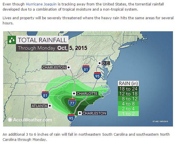
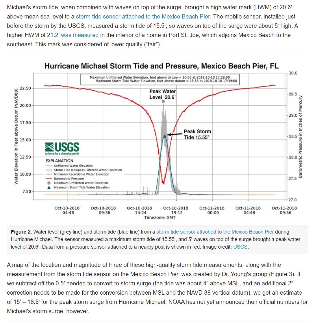
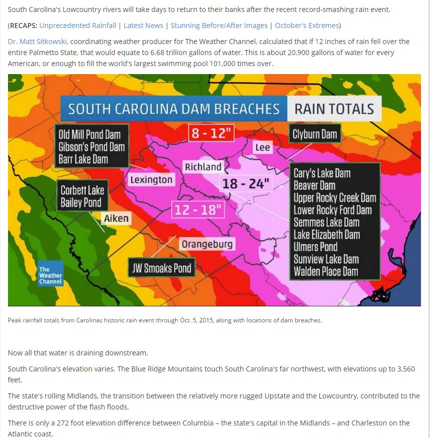
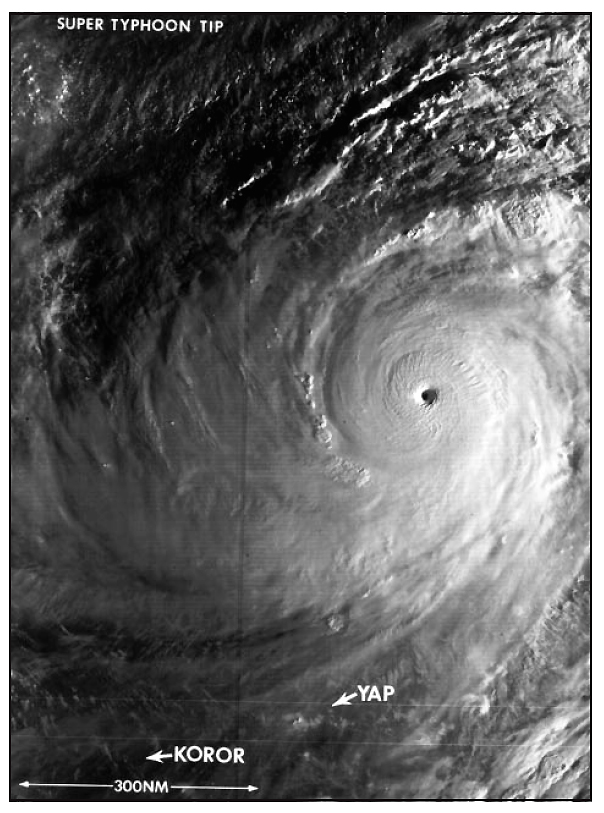
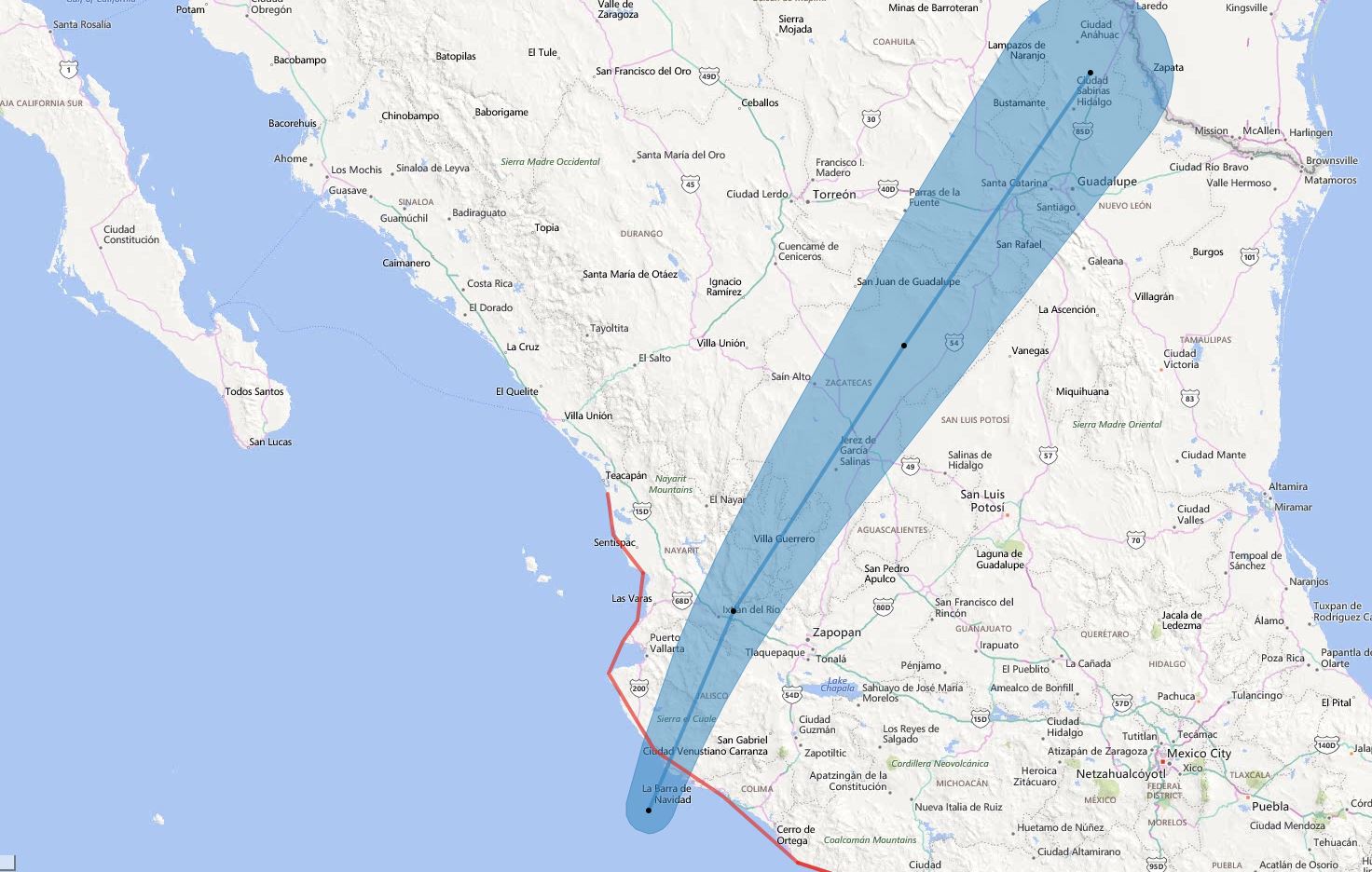
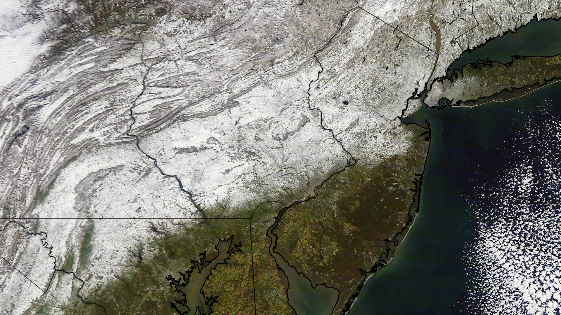
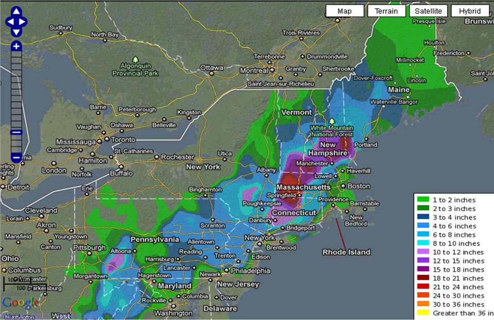
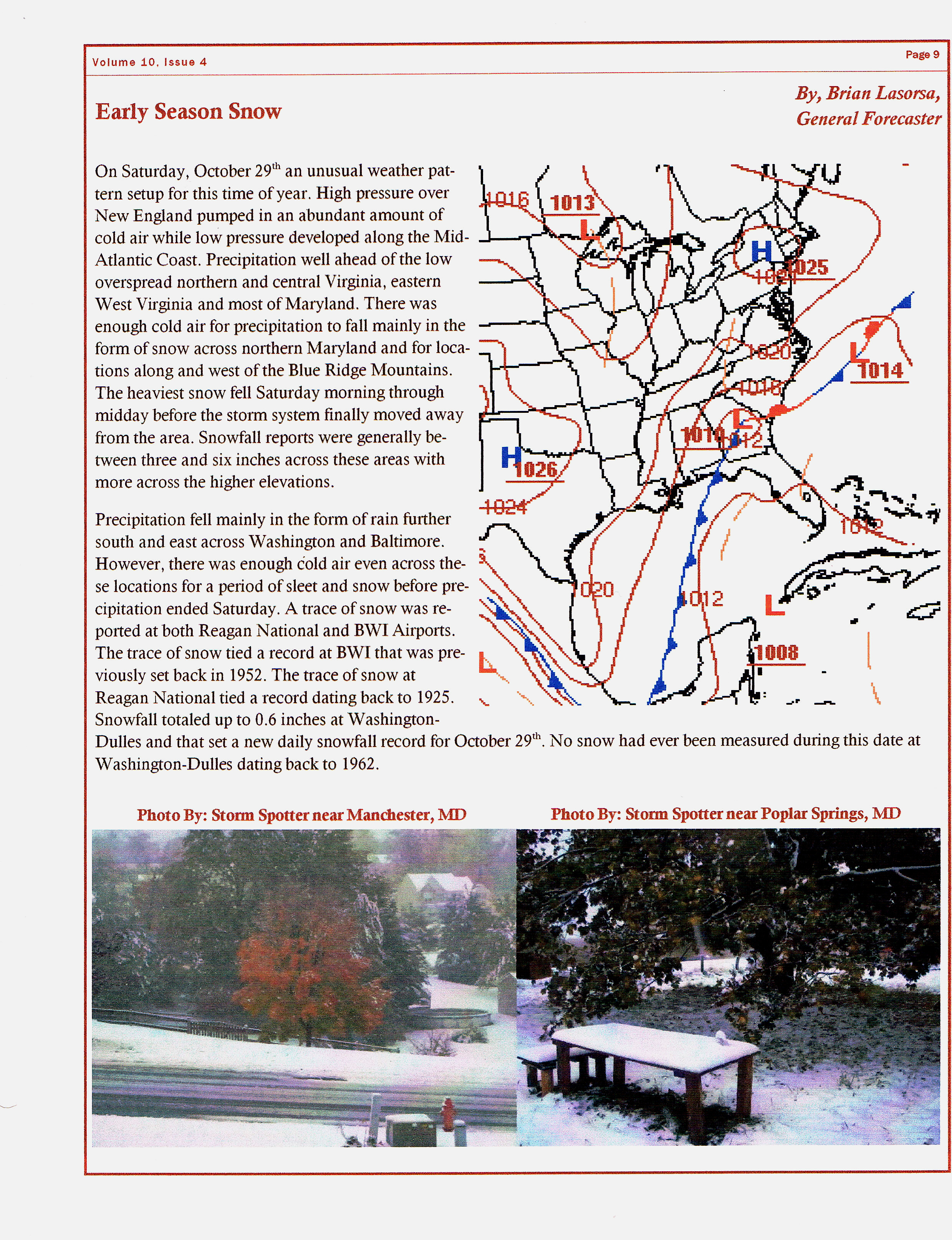