|
MARCH Happy First Day of March 01ST 1835 Once again, arctic air had settled over Virginia and temperatures were in the teens. More than a foot (13.7 inches) of snow fell in Norfolk. The heavy snow combined with strong winds created blizzard conditions. Norfolk's total for the season came to a record 41.9 inches making this the snowiest winter ever for eastern Virginia. (Ref. Virginia Weather History) 1872 The Great Storm of 1872, March 1-2: Winds increased from the northeast to gale force (over 40 mph) on the coast and snow accumulated several inches. The wind drove water into the Tidewater area and rivers. Water rose rapidly, flooding wharves and the lower part of Norfolk. (Ref. Virginia Weather History) 1884 The minimum temperature for the date is 13°F in Washington, DC. (Ref. Washington Weather Records - KDCA) 1899 The first regularly scheduled 48-hour forecast occurred on this date. Up to this time, forecasts only covered the following 36 hours. (Ref. Wilson Wx. History) 1910 The deadliest avalanche of record in the U.S. thundered down the mountains near Wellington Station WA sweeping three huge locomotive train engines and some passenger cars, snowbound on the grade leading to Stevens Pass, over the side and into a canyon, and burying them under tons of snow. The avalanche claimed the lives of more than 100 people. The station house at Wellington was also swept away. (The Weather Channel) 1914 High winds and heavy snow crippled New Jersey and New York State. Two feet of snow were reported at Ashbury Park, New Jersey. At New York City the barometric pressure dropped to a record 28.38 inches. DCA had 6.4 inches in this storm. The storm caused complete disruption of electric power in New Jersey. (David Ludlum) 1958 A 46-hour ice storm, Newfoundland's worst in 30 years, coated tree branches and power lines with up to 2.5 inches of ice. (Ref. Wilson Wx. History) 1962 Arctic high pressure was responsible for extreme morning cold in the Plains. Morning temperatures were in the teens and 20s below zero across the northern Plains with International Falls, MN dropping to -38°. Morning lows dropped to near zero as far south as central Kansas & Missouri, the single digits to northern Oklahoma and Arkansas, teens and 20s to Central Texas and northern Louisiana and the 30s along the Texas coast to Brownsville. (Ref. Wilson Wx. History) 1976 The maximum temperature for the date is 80°F in Washington, DC. (Ref. Washington Weather Records - KDCA) 1980 Cold day National Airport had 5.0 inches snow today with a maximum of 21° and Baltimore had a maximum of 17°F. Dulles had 6.4 inches of snow today. (Ref. Washington Weather Records - KDCA) March in like a lion 5 inches of snow, high only 21° in Washington and 17° in Baltimore. (Bob Ryan's 2000 Almanac) Norfolk VA received 13.7 inches of snow to push their season total to a record 41.9 inches exceeding their previous record by more than four inches. (David Ludlum) This was a very cold snowstorm and gave the Richmond International Airport a total of 10.6 inches of snow making it the largest single day storm for Richmond in March. The high temperature was only 21 °F (the lowest maximum temperature recorded in March) making it one of the colder snows in Richmond, Virginia. The coldest snow being February 12, 1899 when the high was only 11 °F with a 7.5 inch snowfall. (Ref. Richmond Weather Records) An unusually large Florida tornado, 500 yards in width at times, killed one person and caused six million dollars damage near Fort Lauderdale. (The Weather Channel) 1983 A ferocious storm battered the Pacific coast. The storm produced heavy rain and gale force winds resulting in flooding and beach erosion, and in the mountains produced up to seven feet of snow in five days. (The Weather Channel) California Coast from the 1st to the 3rd: The last in a succession of storms to strike the California coast ends. Waves 15 to 20 feet high have pounded the coastline for two days. In a four-day period up to 18 inches of rain drenched the Los Angeles and Santa Barbara area. On the morning of the 1st, severe thunderstorms spawn two tornadoes which moved through the Los Angeles area. (Ref. WxDoctor) 1987 A storm crossing the Great Lakes Region produced heavy snow and gale force winds from Wisconsin to northern New England, with eight inches of snow reported at Ironwood MI. (The National Weather Summary) 1988 Thunderstorms produced large hail and damaging winds in north central Texas. Baseball size hail was reported at Lake Kickapoo. Hail fell continuously for thirty minutes in the Iowa Park area of Wichita Falls. (The National Weather Summary) (Storm Data) 1989 March came in like a lion, with snow and high winds, in the northwestern U.S. Winds gusted to 86 mph in the Rosario Strait of western Washington State. (The National Weather Summary) (Storm Data) 1990 A series of low-pressure systems moving out of the Gulf of Alaska spread high winds and heavy snow across western Alaska. Winds in the Anchorage area gusted to 69 mph at Glen Alps, and Talkeetna was buried under three feet of snow in two days. Valdez received 21.4 inches of snow, raising their total for the winter season to 482.4 inches. (The National Weather Summary) (Storm Data) 1991 Heavy snows occurred over northern Arizona. 50 inches fell at the Fairfield Snowbowl and Flagstaff picked up 31.5 inches. (Ref. Wilson Wx. History) 1993 Dodge City, KS broke their all-time snowfall record for a single season when 4.5 inches fell on this date bringing their seasonal total to 58.8 inches. This surpassed the 1911-12 record of 57.5 inches. (Ref. Wilson Wx. History) 1997 Arkansas, northern Mississippi, and western Tennessee: The deadliest tornado outbreak since 1994 strikes Arkansas, northern Mississippi, and western Tennessee. The strong to violent tornadoes, including several of F4 intensity cause 29 deaths. (Ref. WxDoctor) 1998 73 inches of snow fell from a single storm at Lead, SD accompanied by huge drifts and winds of 60-65 mph. (Ref. Wilson Wx. History) 2006 TexasHeat:The day's high temperature of 93° at the Dallas/Forth Worth Airport in Texas broke a 107-year-old record. Other hot North Texas cities included Wichita Falls: 96° and Fort Worth Meacham Airport with 90°. (Ref. Wilson Wx. History) 2009 The heavy snowfall of March 1st and 2nd started as rain but turned to all snow about 1630 today and 4.9 inches of snow was on the ground by midnight. See tomorrow for the rest of the storm. (Richmond Weather Records) Ref. (NWS Ranking for Storms between 1956 and 2011) This is the 40th Worst Snowstorm 2010 Climate change or just warm weather? No snow fell on Minneapolis, MN, today, or any other day this month-making this the 1st snowless March of record (approximately 10 inches usually falls). The last measurable snow fell was on 2/23, breaking the previous record of 3/5/1938. (Ref. Weather Guide Calendar with Phenomenal Weather Events 2012 Accord Pub. 2011, USA) |
|
MARCH 2ND 1846 A great storm hit Virginia and the Carolinas. The storm caused half a million dollars damage, and in North Carolina drowned fifty families and a thousand cattle on Notts Island. (David Ludlum) 1925 The minimum temperature for the date is 13°F in Washington, DC. (Ref. Washington Weather Records - KDCA) 1927 Raleigh NC was buried under 17.8 inches of snow in 24 hours, a record for that location. Nashville NC received 31 inches of snow. The average snow depth in the state of Carolina was fourteen inches. (The Weather Channel) March 1-3, 1927: Nor'easter high winds gusted to 62 mph at Cape Henry and 52 mph at Norfolk, VA. Heavy snow fell across North Carolina into Virginia and travel was delayed for two to three days. In Virginia Beach, high tide and heavy surf on March 2 inflicted considerable damage. The beaches in some places were washed back 50 feet and denuded of the overlying sand, exposing the clay beneath. (Ref. Virginia Weather History) 1942 Cedartown, GA was buried under 19.3 inches of snow, the 24-hour snowfall record for the state of Georgia. (Ref. Wilson Wx. History) 1969 Snowstorm on first and second, National Airport had 4.2 inches and 7.3 inches fell in the Annandale area and Dulles had 7.5 inches of snow. (Ref. Washington Weather Records - KDCA) 1972 The maximum temperature for the date is 77 °F in Washington, DC. (Ref. Washington Weather Records - KDCA) 1983 An unusual warning to residents of Lake Tahoe, CA: they were advised not to go out cross country skiing as they might ski into power lines. The snow depth was an amazing 215 inches. A major coastal storm ripped out several hundred feet of the Santa Monica pier. (Ref. Wilson Wx. History) 1985 A massive winter storm struck the Northern Plains Region. The storm produced up to 33 inches of snow in northeastern South Dakota, at Summit and at Milbank, and also produced high winds that whipped the heavy snow into drifts twenty feet high. (Storm Data) 1987 A storm in the northeastern U.S. produced heavy snow in Maine, with 16 inches reported at West Grand Lake and Guilford. (The National Weather Summary) (Storm Data) 1988 Thunderstorms produced severe weather in the south central U.S. A tornado at Baton Rouge, LA injured two persons, and another tornado caused five million dollars damage at the airport in Lafayette, LA. (The National Weather Summary) (Storm Data) 1989 Snow and high winds plagued the western U.S. Up to 16 inches of snow was reported south of Seattle WA, and more than two feet of snow blanketed the Sierra Nevada Range of California. Winds gusted to 89 mph at Hidden Peak UT, and reached 92 mph at Peavine, CA. (The National Weather Summary) (Storm Data) 1990 Mild weather continued across the northern tier of states with highs of 52 degrees at Saint Johnsbury, VT and 63 degrees at Olympia WA, and 64 °F at Seattle WA were records for the date. (The National Weather Summary) 1996 Another East Coast snowstorm deposited 4.6 inches of snow at Central Park in New York City to bring its seasonal snowfall total to 66.3 inches, breaking the old season snowfall record of 63.2 inches set in 1947-48. (Ref. Wilson Wx. History) 1998 Lead, SD sets record 9-day snowstorm with a total of 103 inches. (Bob Ryan's 2002 Almanac) 2001 Both Caribou and Bangor, ME set a new all-time March record low temperatures with -28 °F and -16 °F., respectively. (Ref. Wilson Wx. History) 2005 The 220 mile wind run on the 2nd was the highest wind run for any day since wind run records were started here in May of 2002. (Ref. Annandale Weather Records ) 2009 West Henrico Co. - Glen Allen Weather Station recorded 9.0 inches of snow from the snowstorm of March 1st and 2nd. The west end of Richmond was the hardest hit. The Richmond International Airport first reported 5.7 inches that was later revised to 6.3 inches. I got this information from the Wakefield branch of the Weather Service. A Cooperative Weather Observer near the airport (Sandston, VA) reported a much larger amount thus they felt the airport observation was in error and so increased the amount to 6.3 inches. (Ref. West Henrico Co. - Glen Allen VA. Station) In Virginia, Dominion Virginia Power said nearly 123,000 customers were without power, with more than half in the Richmond metropolitan area. Appalachian Power, which serves southwest Virginia, reported about 5,600 outages. Gov. Tim Kaine has declared a state of emergency in response to a winter storm that swept through Virginia. Kaine said in a release that counties, cities and towns were coping well with the most widespread winter storm to come through Virginia in eight years. In North Carolina, Raleigh got more than 3 inches of snow; the March snowfall for the city has exceeded 3 inches only 11 times in the last 122 years. The Weather Service said parts of Tennessee received the biggest snowfall since 1968. Click this link to see a time lapse movie of the snow accumulation This was the biggest snow I have seen since February 11th and 12th 2006 in Northern VA before moving to the Richmond area. But for the people in western Richmond area this was the largest snow they had seen since January 25, 2000. Ref. (NWS Ranking for Storms between 1956 and 2011) This is the 40th Worst Snowstorm 2012 Fourth of the top ten weather events - Southern Tornado Outbreak. March 2. Dozens of tornadoes ripped across 12 states, killing 40 people, including 13 in Indiana and 22 in Kentucky. Damages exceeded $4 billion. Top 2012 Weather Events (Ref.Weatherwise May/June 2013 volumn 66 /number3 page 17) |
|
MARCH 3RD 1896 The temperature in downtown San Francisco, CA fell to 33°, which was the lowest ever for the city in March. (Ref. Wilson Wx. History) 1923 The maximum temperature for the date is 79 °F in Washington, DC. (Ref. Washington Weather Records - KDCA) 1925 The minimum temperature for the date is 11°F in Washington, DC. (Ref. Washington Weather Records - KDCA) 1942 Asheville, NC picked up 15.8 inches of snow to establish their 24-hour snowfall record. (Ref. Wilson Wx. History) 1947 Vermont and northwestern Massachusetts had their biggest snowstorm in this century when Readsboro, in southern Vermont, received 50 inches in 3 days, and Peru, in northwestern Massachusetts, received 47 inches in 3 days. (Ref. Wilson Wx. History) 1953 Oahu, Hawaii: Snow falls on the island of Oahu. (Ref. WxDoctor) 1960 Eastern Massachusetts' greatest March snowstorm occurred from this date through the 5th. The storm produced record 24-hour snowfall totals of 27.2 inches at Blue Hill Observatory, 17.7 inches at Worcester, and 16.6 inches at Boston. Winds gusted to 70 mph. (Ref. Wilson Wx. History) 1966 A tornado hit Jackson MS killing 54 persons. (David Ludlum) (Ref. Wilson More Information About This Storm) 1971 An extremely intense coastal storm blasted the northeastern U.S. and continued into the 4th. The barometric pressure dropped to 960 millibars or 28.36 inches of mercury at Worcester, MA for the lowest pressure ever recorded at the location. The same record was set at Concord, NH with a reading of 963 millibars or 28.44 inHg. Wind gusts 70 to 100 mph lashed eastern New England with major wind damage. Tides ran 4 to 5 feet above normal resulting in extensive coastal flooding. (Ref. Wilson Wx. History) 1980 A coastal storm produced 25 inches of snow at Elizabeth City, NC and 30 inches at Cape Hatteras NC. At Miami FL the mercury dipped to 32 degrees. (Sandra and TI Richard Sanders - 1987) 1983 The last of a series of storms to strike the California coast finally came to an end. Waves fifteen to twenty feet high pounded the coast for two days, and in a four day period up to 18 inches of rain drenched the Los Angeles and Santa Barbara area. On the morning of the first, thunderstorms spawned two tornadoes that moved through the Los Angeles area. (Storm Data) 1987 A storm brought heavy rain and gale force winds to Washington and Oregon. Quillayute, WA received 2.67 inches of rain in 24 hours, and winds gusted to 60 mph at Astoria OR. (The National Weather Summary) (Storm Data) 1988 A small but intense low-pressure system roared across west central Mississippi at 90 mph early in the morning. A tornado in southern Mississippi picked up an automobile, carried it 150 feet, and tossed it through the brick wall of an unoccupied retirement home. (The National Weather Summary) (Storm Data) 1989 Wintry weather prevailed from the southern Rockies to the Upper Great Lakes. Neguanee, MI received 19 inches of snow, and up to 24 inches of snow blanketed Colorado. Blizzard conditions were reported in Minnesota. (The National Weather Summary) (Storm Data) The high in Oklahoma City, OK on this date was 74°, but a strong cold front dropped the mercury an amazing 51° to a midnight reading of 23°. The morning low the next morning was 16°. Amazingly, no records were set in this cold wave episode that rivaled the famous 1911 Blue Northern on the Plains. (Ref. Wilson Wx. History) 1990 An upper level weather disturbance produced snow in the Colorado Rockies, with eight inches reported at Winter Park. The storm then moved off the Pacific Ocean began to spread rain and snow across the western U.S. March continued to start off "like a lamb" elsewhere around the country. (The National Weather Summary) (Storm Data) 1991 A major ice storm coated parts of central and northwestern New York State with up to two inches of ice. Damage was totaled at $375 million dollars. It was the most costly natural disaster ever in the state up until that time. Nearly half a million people were without power at the height of the storm and many would not see their power restored until the 16th. (Ref. Wilson Wx. History) 1994 Deep low tracks east coast, 20-30 inches of snow in western VA, Dove, DE wind gust to 70 mph and severe coastal erosion, seas 25 feet off of Hatteras, NC another one to two feet of snow from WV to New England. (Bob Ryan's 2000 Almanac) A major coastal storm was in progress over the mid-Atlantic and the northeast. Winds gusts hit 75 mph at Dover, DE. Big snows buried interior sections. Two day snowfall totals 33 inches at Burdett, NY, 30 inches at Frankfort Center, NY, 29 inches at Loganton, PA, 26 inches at Jay Peak, VT, and 22 inches at Frostburg, MD. The 8.7 inches of snow at Allentown, PA raised their seasonal snowfall to 69.2 inches for their snowiest winter ever. Boston's 8 inches pushed its seasonal snow to 89.5 inches for their snowiest winter as well. The maximum 24-hour snowfall total for the state of Virginia was set today with 33.5 inches at Luray , Virginia on March 2-3, 1994. (Ref. Wilson Wx. History) 1997 Dozens of rivers, saturated with heavy rains, jumped their banks from Arkansas to West Virginia. In Louisville, KY, crews were closing all 45 gates in the city's flood wall along the Ohio and were preparing to reinforce them with 120,000 sandbags. Across the river in Indiana, waterfront communities started evacuating. (Ref. Wilson Wx. History) 2003 Miami, Florida: The day's high temperature of 90 °F is the earliest observed 90 °F at Miami since March 5, 1964. (Ref. WxDoctor) Marquette, Michigan: The day's low temperature of 30 °F below zero is the lowest temperature ever recorded in March in the city. (Ref. WxDoctor) 2009 The Richmond International Airport temperature dropped to 11 °F this morning and sets a new record low temperature for the date. The old record for the date was 14 °F in 1925. (Ref. Richmond Weather Records - KRIC) The Glen Allen - Springfield Park area Weather Station had a minimum of 7 °F this morning the second lowest temperature for the winter the lowest was 4 °F on January 17,2009. (Ref. West Henrico Co. - Glen Allen, VA Station ) |
|
MARCH 4TH 1717 New England's "Great Snow." occurred between 2/27 and 3/7. Four storms dumped 36 inches of snow at Boston, MA and as much as 4 feet further north. Drifts up to 25 feet were reported near Dorchester, MA. Travel was virtually impossible for nearly 3 weeks. (Ref. Wilson Wx. History) 1780 Because of the very cold winter of 1779 - 1780 the port of Philadelphia was ice locked from December 21, 1779 until March 4, 1780. (p.30 Washington Weather Book 2002 by Ambrose, Henry, Weiss) 1846 "The wind continued from the NNE, accompanied by snow and "hail" until nearly 12 o'clock Monday night...Damage... confined to unroofing of residences...blowing down of (some buildings) damage...to shipping (was) immense." (Ref. The American Beacon, March 4, 1846) 1873 The inauguration of Ulysses S. Grant remains Washington, DC’s, record cold March day. The low was 4 degrees; by noon (with sunshine) the temperature was 16 degrees (wind chills to -30 degrees). 40 mph winds made his inaugural address inaudible to most on the platform with him. (Ref. Weather Guide Calendar with Phenomenal Weather Events 2011 Accord Pub. 2010, USA) The minimum temperature for the date is 4 °F in Washington, DC. (Ref. Washington Weather Records - KDCA) 1899 Cyclone Mahina, aka “The Bathurst Bay Hurricane” in Australia was credited with having produced the highest storm surge on record in the world. The cyclone, with an estimated central pressure of 911 millibars or 26.90 inches of mercury caused a 42.6 foot surge when it came ashore on the coast of northern Australia. The storm killed as many as 400 people. (Ref. Wilson Wx. History) 1909 Though fair weather was forecast, President Taft was inaugurated amidst a furious storm. 9.8 inches of wet snow disrupted travel and communications. The storm drew much criticism against the U.S. Weather Bureau. (David Ludlum) The head of the Washington Weather Bureau personally called Mr. Taft at midnight before and stated that the snow would soon be over. He reiterated his promise that the weather would not interfere with any of the inaugural activities. What happen was the storm rapidly intensified over southern NJ and a unusually heavy wraparound snow event occurred. (p.54 Washington Weather Book 2002 by Ambrose, Henry, Weiss) 1910 An avalanche swept down Cheops Mountain and hit a work train and crew cleaning a previous slide at Rogers Pass, British Columbia Canada. All but one of the 63-man crew died. (Ref. Wilson Wx. History) 1951 In Riverside, CA it was 28°, their lowest temperature on record for March. (Ref. Wilson Wx. History) 1952 It was 29° at Palm Springs, CA; their lowest temperature on record for March. This also occurred on 3/13/1936. (Ref. Wilson Wx. History) 1953 Snow was reported on the island of Oahu in Hawaii. (The Weather Channel) 1960 A ferocious blizzard that began on the 3rd struck the mid-Atlantic and northeast. Some snowfall totals included 17 inches at Roanoke, VA and 18 inches at Scranton, PA. The storm was especially fierce in eastern New England where the winds approached hurricane force. In Massachusetts, Blue Hill in Milton, totaled 30 inches, Nantucket was buried under 31 inches, and Boston recorded 20 inches. Just offshore the storm's central pressure bottomed out at 960 millibars or 28.35 inches of mercury. (Ref. Wilson Wx. History) 1966 A severe blizzard raged across Minnesota and North Dakota. The blizzard lasted four days producing up to 35 inches of snow, and wind gusting to 100 mph produced snowdrifts 30 to 40 feet high. Bismarck ND reported zero visibility for 11 hours. Traffic was paralyzed for three days. (2nd-5th) Across the border in Winnipeg, Manitoba Canada the blizzard dropped 13 inches of snow with wind gusts up to 75 mph, paralyzing the city for two days. (Ref. Wilson Wx. History) (The Weather Channel) 1983 The maximum temperature for the date is 82 °F in Washington, DC. (Ref. Washington Weather Records - KDCA) Brownsville, TX recorded a high of 100°, the earliest the city has ever hit the century mark. (Ref. Wilson Wx. History) 1985 A blizzard, which began on the 2nd, battered the Upper Midwest. 15 to 25 inches of snow was common across South Dakota with drifts up to 20 feet. 24 inches was recorded at Benson, MN and Duluth, MN had a wind gust to 71 mph. Most highways and state roads were closed for 2 days. Thunderstorms with brilliant lightning displays were also reported with the heavy snow. (Ref. Wilson Wx. History) 1987 Rain and high winds prevailed in the northwestern U.S. A wind gust to 69 mph at Klamath Falls, Oregon was the highest wind in the last 25 years, and winds at the Ashland Ranger Station in the Siskiyou Mountains of northern California reached 85 mph. (The National Weather Summary) (Storm Data) 1988 Snow and freezing rain made travel hazardous in Ohio and Indiana. A six car pile-up resulted near Columbus OH, with seven injuries reported. Up to two inches of ice glazed central Indiana. Up to ten inches of snow blanketed northern Ohio. (The National Weather Summary) (Storm Data) 1989 Thunderstorms produced severe weather in the Lower Mississippi Valley. A strong (F-3) tornado injured five persons near Brownsville MS, and killed seven cows and two hogs in one pasture. Thunderstorm winds gusted to 90 mph at Canton MS. (The National Weather Summary) (Storm Data) 1990 A Pacific cold front working its way across the western U.S. produced heavy snow over parts of Idaho, Nevada and Utah. Up to eleven inches of snow blanketed the valleys of northwest Utah, while 12 to 25 inches fell across the mountains of northern Utah. Up to six inches of snow blanketed the valleys of east central Nevada, while more than a foot of snow was reported in the high elevations. In Idaho, 6 to 8 inches of snow was reported around Aberdeen and American Falls. (The National Weather Summary) (Storm Data) 1997 The river front area of Cincinnati, OH was under water, as the Ohio River hit 63.33 feet; more than 11 feet above flood stage. (Ref. Wilson Wx. History) 1999 March snowstorm dumps heavy snow from MD to New England. Rochester, NY sets all time 24-hour snowfall record with 24.3 inches. (Bob Ryan's 2002 Almanac) 2004 Oklahoma reported its first tornado in 292 days, a record stretch of days without a reported tornado that began 5/16/2003. An F-0 tornado touched down 2 miles north of Muldrow to break the string. (Ref. Wilson Wx. History) 2008 St Louis, Missouri: Only two days after basking in a summer-like 78 °F St Louis is buried under nearly a foot of snow in 7 hours, the biggest snowstorm in 15 years. (Ref. WxDoctor) 2009 The temperature at the Richmond International Airport dropped to 10 degrees this morning and sets a new record low temperature for the date. It was also 10 °F at the West Henrico Co. - Glen Allen Weather Station. The old record for the Richmond International Airport was 11 °F set in 1943. This also establishes a new record low temperature for the month of March breaking the old record of 11 °F set on several previous dates. (Ref. Richmond Weather Records - KRIC) |
|
MARCH 5TH 1821 President James Monroe's inauguration was only the 2nd to be held outdoors. The weather did not cooperate, as a mix of rain and snow fell with temperatures in the upper 20’s. (Ref. Wilson Wx. History) 1872 The minimum temperature for the date is 6 °F in Washington, DC. This is the latest in season the temperature has fallen below ten degrees F. (Ref. Washington Weather Records - KDCA) It was the most severe modern March cold wave in the East. Boston, MA had a low of -8° on the 6th, the coldest in March since 1833. (Ref. Wilson Wx. History) 1894 The low temperature of 36° at San Diego, CA on this day was their lowest on record for March. (Ref. Wilson Wx. History) 1958 Honolulu, HI recorded 17.41 inches of rain to set their all-time 24-hour rainfall record. (Ref. Wilson Wx. History) 1959 Near blizzard conditions occurred over northern and central Oklahoma. Up to seven inches of snow fell, and winds up to 50 mph created snow drifts 4 to 8 feet deep. In Edmond, a bus slid off the road into a ditch and overturned, injuring 16 people. (Ref. Wilson Wx. History) 1960 Massachusetts from the 3rd to the 5th: Eastern Massachusetts' greatest March snowstorm of record began to abate. The storm produced record 24-hour snowfall totals of 27.2 inches at Blue Hill Observatory, 17.7 inches at Worcester, and 16.6 inches at Boston. Winds gusted to 70 mph. (The Weather Channel) This same storm earlier dropped 4 to 20 inches in Virginia. Twelve deaths were attributed to the storm in Virginia. (Ref. Virginia Weather History) Ref. (NWS Ranking for Storms between 1956 and 2011) This is the 3rd Worst Snowstorm 1962 A tremendous storm raged along the Atlantic coast. The great Atlantic storm caused more than 200 million dollars property damage from Florida to New England. Winds along the Middle Atlantic Coast reached 70 mph raising forty foot waves, and as much as 33 inches of snow blanketed the mountains of Virginia. The Virginia shoreline was rearranged by historic tidal flooding caused by the combination of the long stretch of strong onshore winds and the "Spring Tides". (Click this link to see a story of this Great March Snowstorm - -Ref. Lowell Koontz) 1972 It was 100° at Palm Springs, CA; the earliest date in the year to reach the century mark on record. (Ref. Wilson Wx. History) 1976 The maximum temperature for the date is 83 °F in Washington, DC. (Ref. Washington Weather Records - KDCA) 1987 A storm in the western U.S. produced heavy rain and high winds in California. Up to six inches of rain soaked the San Francisco Bay area in 24 hours, and winds gusted to 100 mph at the Wheeler Ridge Pumping Plant near the Tehachapi Mountains. (The National Weather Summary) (Storm Data) 1988 While snow blanketed eastern Kansas and northern Oklahoma, eight cities in North Dakota reported new record high temperatures for the date. The afternoon high of 61 degrees at Bismarck, ND was 27 degrees warmer than that at Chanute, KS. (The National Weather Summary) (Storm Data) 1989 Thunderstorms produced severe weather in the southeastern U.S. A strong (F-2) tornado killed one person and injured six others in Heard County GA. A strong (F-3) tornado injured 23 persons and caused more than five million dollars damage around Grantville GA. (The National Weather Summary) (Storm Data) 1990 Thunderstorms over eastern Colorado, developing ahead of a major storm system, produced up to three inches of small hail around Colorado Springs in the late morning and early afternoon. Strong thunderstorms swept through southeastern sections of the Denver area during the evening hours. These strong thunderstorms also produced up to three inches of small hail, along with wind gusts to 50 mph, and as much as 2.4 inches of rain. (The National Weather Summary) (Storm Data) 1994 Snowiest winter ever at Elkins, WV 124 inches, Erie, PA 125 inches, also Boston, Binghamton, Hartford and Worcester until record broken again in 1996. (Bob Ryan's 2000 Almanac) 1998 Hail depth in Leakesville, MS was 6-12 inches (generally dime to golf ball-size); drifts were to the bottom of the elementary school’s windows. Much damage-- (Ref. Weather Guide Calendar with Phenomenal Weather Events 2011 Accord Pub. 2010, USA) 2000 A major wildfire near Miami, FL threatened homes as southern Florida continued in its worst drought in 200 years. Rainfall amounts were as much 5 feet below normal over the preceding 3 years. The Florida Aquifer, which supplies most of the potable water, was reportedly at its lowest level in history as intense development combined with the drought reduced water levels. Minneapolis, MNestablished a new record for the fewest number of days between 70° temperature readings; from the last date in the autumn to the first date in the spring. This season only 113 days passed, the previous record was 131 days, the average, 175 days. (Ref. Wilson Wx. History) 2001 The snowstorm that missed the Washington, DC area gave this station only 1.5 inches of snow. Little snow here but 20 to 40 inches fell in New England. (Bob Ryan's 2002 Almanac) 2007 The morning temperature dropped to -51° at Key Lake, Saskatchewan Canada. (Ref. Wilson Wx. History) 2015 This snow was very icy with a lot of sleet graupel and heavy riming. A core sample of the 1.5 inches had 0.41 inches of liquid. The snow to liquid equivalent ratio was 3.7 to 1. Much of the storm fell as rain with a liquid total of 1.01 inches for the day. Accumulating sleet didn't start until about 1300. Heavy snow to the north and west see map below. (Ref.Channel 12 Forecast) (Ref.Storm Summary) (Ref.Storm video) (Ref.NWS (Ref.Kevin Shaw-about 8 inches of snow) (Ref.Kevin Shaw-about 8 inches of snow) (Ref.LLK a short period of heavy snow) Boston's 2015 Snow Blitz-How Did it Compare? (Ref.Weatherwise-Sep/Oct2015-Vol 68/ number 5 |
|
MARCH 6TH 1872 A cold wave hit the East coast sending the mercury plunging to 8 degrees below zero at Boston. It was the most severe March cold wave in modern history. (David Ludlum) 1888 The minimum temperature for the date is 10 °F in Washington, DC. (Ref. Washington Weather Records - KDCA) 1900 Chinook wind blowing down the slopes of the Rockies through Havre MT raised the temperature 31 degrees in just three minutes. (The Weather Channel) 1912 This as a long duration four day spring storm with 2.8 inches of snow on the 3rd, 0.1 inches on the 4th, 0.7 inches on the 5th and 7.0 inches on the 6th. As long as each day has a measurable amount of snow it is considered as one storm. The following newspaper article is from the 7th giving information about the storm A 4 Day Early March Storm (Ref. Richmond Newspaper) 1932 Blizzard hits the Shenandoah Valley (Ref. Daily News Record Newspaper - Harrisonburg, Virginia) 1954 Florida received its greatest modern-day snowfall of record, with 4.0 inches at the Milton Experimental Station. Pensacola FL equaled their 24-hour record with 2.1 inches of snow. (The Weather Channel) 1961 The maximum temperature for the date is 81 °F in Washington, DC. (Ref. Washington Weather Records - KDCA) 1962 Atlantic storm 70 mph and 40-foot waves, 33.0 inches of snow in 24 hours at Big Meadows. Big Meadows on the Skyline Drive received 42.0 inches of snow for the storm that was a new Virginia storm total record at the time until the storm of January 6-7, 1996 when 48 inches fell in one storm at Big Meadows. Depths 20 to 40 inches in the Shenandoah Valley and the total damage was $200 million. (The GREAT March Snowstorm - -Ref. Lowell Koontz) The NWS write up - - - - The strongest nor'easter of this century struck the Mid Atlantic Region on March 5-9, 1962. It is known as the "Ash Wednesday Storm." It caused over $200 million (1962 dollars) in property damage and major coastal erosion from North Carolina to Long Island, NY. In New Jersey alone, it was estimated to have destroyed or greatly damaged 45,000 homes. The Red Cross recorded that the storm killed 40 people. It hit during "Spring Tide." When the sun and moon are in phase, they produce a higher than normal astronomical tide. Water reached nine feet at Norfolk (flooding begins around five feet). Houses were toppled into the ocean and boardwalks were broken and twisted. The islands of Chincoteague and Assateague, Maryland were completely underwater. Ocean City, Maryland sustained major damage especially to the south end of the island. Winds up to 70 mph built 40-foot waves at sea. Heavy snow fell in the Appalachian Mountains. Big Meadows, southeast of Luray, recorded Virginia's greatest 24-hour snowfall with 33 inches and the greatest single storm snowfall with 42 inches. (Luray, Virginia reported 33.5 inches on March 2-3, 1994 making this later snow their maximum 24-hour snowfall total.) Nearly two feet of snow fell from Charlottesville, VA (21 inches) to Luray, VA (24 inches) to Winchester, VA (22 inches). Roads were blocked and electrical service was out for several days. Washington and Baltimore fell into the mixed precipitation zone. The Ash Wednesday storm is noteworthy for producing devastating tidal flooding along the Atlantic Coast as well as record snows and the interior of a Virginia. The extremely high tides and massive waves caused tremendous damage -worst in many of the hurricanes that have hit the region. Along the Atlantic Coast tide ran for 2 to 6 ft. above normal with 20 to 40 ft. waves crashing ashore. National Airport received only 4 inches of snow with a liquid equivalent of 1.33 inches. However, close-in suburbs, such as Silver Spring, Md. and Falls Church, Virginia and received 11 inches of snow. Outlying areas such as Rockville, Maryland received 19 inches of snow and Leesburg, Virginia received 20 inches of snow. Other snow totals included 15 inches at Richmond; 23 inches at Culpeper; 26 inches at Charlottesville; 32 inches at Winchester; and 35 inches at Fort Royal, Virginia and Big Meadows on the Skyline Drive top the list with 42 inches of snow. (p. 73-76 Washington Weather Book 2002 by Ambrose, Henry, Weiss) (Ref. Wilson Wx. History) (Ref. Virginia Climate Summary) (Ref. New England Climate Summary) (Ref. NY Climate Summary) (Ref. New Jersey Climate Summary) 1967 An F4 tornado cut a 30 mile path across Walker and Jefferson Counties in Alabama, killing 2 people. Hardest hit locations included Sumiton, Rocky Hollow, Empire and Warrior. (Ref. Wilson Wx. History) 1984 Heavy rains soaked Florida for 24 hours with rainfall totals reaching as high as 9 inches at Whigham and 9.55 inches at Marianna. (Ref. Wilson Wx. History) 1987 Twenty-eight cities in the north central U.S. reported record high temperatures for the date. Pickstown, SD was the hot spot in the nation with a reading of 83 degrees. The high of 71 at Saint Cloud MN smashed their previous record by 21 degrees. (The National Weather Summary) 1988 Wintry weather developed in the Rockies and the Plateau Region as arctic air swept in from the northwest. Blizzard conditions in southeast Idaho claimed the lives of two teenagers. Thunderstorms developed in Utah and Idaho. (The National Weather Summary) (Storm Data) 1989 A winter storm in the south central U.S. left parts of Missouri and Arkansas buried under more than a foot of snow. Heavier snowfall totals in Missouri included 14 inches at Springfield and 16 inches at Lebanon. Totals in Benton County AR ranged up to 14 inches. (The National Weather Summary) (Storm Data) 1990 Colorado's strongest winter storm of the season moved northeastward across the state producing 50 inches of snow at Echo Lake, 46.5 inches on Buckhorn Mountain, and 46 inches near the top of Coal Canyon. Snow fell at the rate of several inches per hour during the height of the storm, while winds gusted above 50 mph. Several hundred rush hour commuters, including the state governor, were stranded in blizzard conditions along Highway 36 between Denver and Boulder. Drifts up to twelve feet high had to be cleared southeast of Boulder. (The National Weather Summary) (Storm Data) At the University of Denver High Altitude Lab, Mount Evans reported 50 inches of snow in a 24 hour period. Winds gusting up to 40 mph caused whiteout conditions. (Ref. Wilson Wx. History) 1992 Severe thunderstorms dumped large amounts of hail over sections of Georgia and Florida. Hail accumulated to a depth of 6 inches at Marietta, Georgia. Hail the size of golf balls covered the ground 3 to 4 inches deep uniformly at Longwood and Altamonte Springs, FL. Hail damage was extensive with broken windows and vehicle and roof damage widespread. Total damage in Florida amounted to $25 million dollars, the most damaging hailstorm in Florida's history (until 3/25/92). (Ref. Wilson Wx. History) 1996 Alabama tornadoes killed 7 people and injured 45 others. Just after 4:00 am, a tornado touched down 9 miles west of Selma, AL, and moved east-northeast on a path at least 10 miles long. A trailer park was hit just north of Selma, killing 4 people. Another tornado just east of Montgomery killed 2 people. An early morning strong F3 tornado killed 4 people and injured 40 others on a 19 mile track through Dallas County in Alabama. Damages totaled $8 million dollars. (Ref. Wilson Wx. History) 1999 Rochester, NY recorded its deepest snow cover on record with 36 inches on the ground. (Ref. Wilson Wx. History) 2003 For the first time since 1979, Lake Superior was nearly frozen over. A winter of relentlessly cold temperatures resulted in the extensive ice. Lake Huron and shallower Lake Erie were both completely covered with ice. The ice threatened to push the opening of shipping on the lake back from late March when it would normally open to late May. In Canada, the thermometer struggled to reach a high of -29° at Timmins Ontario. Further to the west, extreme cold was felt in British Columbia as MacKenzie established a new record low of -27°. Blue River recorded a low of -29°, surpassing their previous record low by 12° as did Bonilla Island at -33°. (Ref. Wilson Wx. History) 2014 The Great Lakes saw some of their worst ice cover in nearly four decades because of a frigid winter with months of below-freezing temperatures in large sections of the northern United States, the National Ocean and Atmospheric Administration said. As of Mach 6, 2014, 92.2 percent of the five lakes were under ice, breaking a record set in 1973 but still short of the 94.7 percent set in 1979, the federal agency said. (Ref.Source: Reuters, 3/7/14) |
|
MARCH 7TH 1717 Long Island, New York: On Fishers Island in Long Island Sound, 1200 sheep are discovered buried under a snow drift for four weeks. When finally uncovered, one hundred sheep are still alive. (Ref. WxDoctor) The "Great Snow", a composite of four winter storms to hit the eastern U.S. in nine days, finally came to an end. Snow depths averaged 60 inches following the storm. Up to four feet of snow fell around Boston MA, and snow drifts 25 feet high were reported around Dorchester MA. (David Ludlum) (The Weather Channel) An event unparalleled in modern times! How would this be handled by today’s media? How would the affected citizenry react? E New England’s “Great Snow” (4 storms beginning 2/27) ended today. Boston, MA area depths to 4 feet; 25 foot snow drifts in Dorchester, MA. (Ref. Weather Guide Calendar with Phenomenal Weather Events 2012 Accord Pub. 2011, USA) 1890 The minimum temperature for the date is 13 °F in Washington, DC. (Ref. Washington Weather Records - KDCA) 1932 A severe coastal storm set barometric pressure records from Virginia to New England. Block Island RI reported a barometric pressure reading of 28.20 inches. (David Ludlum) Other barometric pressure records recorded at Atlantic City, NJ 28.37 inches, Norfolk, VA 28.35 inches. (Bob Ryan's 2002 Almanac) 1961 The maximum temperature for the date is 77 °F in Washington, DC. (Ref. Washington Weather Records - KDCA) 1970 Last near total eclipse of the sun in Washington, DC in this century. Sun was 95% eclipsed. (Ref. Washington Weather Records - KDCA) 1972 It was 80° at Big Bear Lake, CA; their highest temperature on record for March. (Ref. Wilson Wx. History) 1987 Forty-five cities in the north central and northeastern U.S. reported record high temperatures for the date. Huron SD hit 80 degrees, and Pickstown, SD reached 81 degrees. Rochester MN and Rockford IL smashed their previous record for the date by sixteen degrees. (The National Weather Summary) 1988 High winds along a sharp cold front ushered snow and arctic cold into the Central Rocky Mountain Region and the Northern Plains. Snowfall totals in Utah ranged up to sixteen inches at Brighton. Winds gusted to 66 mph at Rapid City SD. (The National Weather Summary) (Storm Data) 1989 Blustery northwest winds ushered arctic cold into eastern U.S. Burlington VT reported a record low of 14 degrees below zero. Snow and ice over the Carolinas replaced the 80°F weather of the previous day. High winds and heavy surf caused five million dollars damage along the North Carolina coast. (The National Weather Summary) (Storm Data) 1990 A major ice storm left much of Iowa under a thick coat of ice. It was the worst ice storm in at least twenty-five years for Iowa, perhaps the worst of the century. Up to two inches of ice coated much of western and central Iowa, with three inches reported in Crawford County and Carroll County. As much as five inches of ice was reported on some electrical lines. The ice downed 78 towers in a 17-mile stretch of a high voltage feeder near Boone costing three electric utilities fifteen million dollars. Damage to trees was incredible, and clean-up costs alone ran into the millions. Total damage from the storm was more than fifty million dollars. (Storm Data) 1996 6.5 inches of snow fell at Boston, MA to bring their seasonal total to 96.4 inches, their city's snowiest winter in 105 years of record keeping. The old record was 96.3 inches set in the 1993-94 winter season. With the Boston record, all major cities along this East Coast had broken their seasonal snowfall records in the 1995-96 winter season. The low of -6° established the record low for the month of March at Garden City, KS. (Ref. Wilson Wx. History) 1997 The worst was finally over for states hit hard by the flooding Ohio River. The river crested on the 6th at Louisville, KY, at 15 feet above flood stage, after topping out at nearly 13 feet at Cincinnati, OH and more than 7 feet at Huntington, WV. (Ref. Wilson Wx. History) 1998 Blizzard conditions began during the afternoon hours across southwest Kansas and lasted until the morning of the 8th. Almost all highways were closed for several hours with 30 to 40 mph winds causing zero to near zero visibilities. Final snowfall totals ranged from 3 to 4 inches in Finney, Seward and Comanche counties to 6 inches in Morton County, 7 inches in Gray County and 8 to 10 inches in Stafford, Pratt and Ford counties. Drifts were as high as 8 feet in some areas. (Ref. Wilson Wx. History) 1999 Two snowstorms in a little over 3 days dumped 43.2 inches of snow at Rochester, NY. (Ref. Wilson Wx. History) 2000 A tornado touched down for about 3 minutes in Liberal, KS during the late afternoon hours. One third of a hospital roof was removed, a KDOT tower was blown down and several trees were uprooted. Sheds were destroyed, the awning at a gas station was damaged and signs were blown down. Estimated property damage was $250,000 dollars. (Ref. Wilson Wx. History) |
|
MARCH 8TH 1717 Twelve hundred sheep on Fishers Island in Long Island Sound were buried under a snowdrift for four weeks. When finally uncovered, one hundred sheep were still alive. (The Weather Channel) 1879 An intense afternoon thunderstorm brought lightning and hail to Erin, Ontario Canada. Some hail stones measured 1.5 inches in diameter. (Ref. Wilson Wx. History) 1883 The minimum temperature for the date is 14 °F in Washington, DC. (Ref. Washington Weather Records - KDCA) 1909 The town of Brinkley, AR was struck by a F4 tornado, which killed 49 persons and caused 600,000 dollars damage. The tornado, which was two-thirds of a mile in width, destroyed 860 buildings. Entire families were killed as houses were completely swept away by the tornado. Tornadoes killed 64 persons and injured 671 others in Dallas and Monroe counties during the Arkansas tornado outbreak. (David Ludlum) 1921 The maximum temperature today was 77 °F in Washington, DC. (Ref. Washington Weather Records - KDCA) 1971 A snowstorm dropped 10 to 20 inches of new snow across Vermont to raise snow depths to record levels. 116 inches was measured on the ground on top of Mount Mansfield, the second highest snow depth ever recorded on the mountain up to the time. The town of Orange measured 88 inches on the ground for a new state low elevation snow depth record. (Ref. Wilson Wx. History) 1972 A wind gust of 207 mph was recorded at the Thule Air Force Base in Greenland. Winds were sustained at over 146 mph for three hours during the storm. (Ref. Wilson Wx. History) 1984 A freak "thunder snowstorm" produced high winds, vivid lightning, and up to seven inches of snow in the northern suburbs of Washington, DC. (Sandra and TI Richard Sanders - 1987) 1987 Thirty-two cities in the eastern U.S. reported new record high temperatures for the date, including Madison WI with a reading of 71 degrees. Afternoon highs of 68 degrees at Houghton Lake MI and 72 degrees at Flint MI smashed their previous records for the date by fourteen degrees. (The National Weather Summary) 1988 A cold front brought wintry weather to the north central U.S. Snowfall totals in northwestern Minnesota ranged up to eight inches at Roseau and Hallock. Winds in South Dakota gusted to 61 mph at Brookings. (The National Weather Summary) (Storm Data) 1989 While arctic cold gripped the northeastern U.S., unseasonably warm weather prevailed across the southwestern states. Albany NY reported a record low of 2 degrees below zero. Tucson AZ reported a record high of 90 degrees. (The National Weather Summary) 1990 Late afternoon thunderstorms produced severe weather in east central Iowa and west central Illinois. Thunderstorms spawned a tornado south of Augusta IL that traveled 42 miles to Marbleton, IL. Golf ball size hail was reported at Peoria IL and near Vermont IL. (The National Weather Summary) (Storm Data) 1992 A cold front that surged through the southern Plains caused severe thunderstorms over much of northern Texas, and southern and central Oklahoma. Four minor tornadoes occurred, along with widespread large hail. Softball size hail fell just east of Ratliff City in Carter County. High winds and hail destroyed several buildings in the Ardmore area, and in western north Texas, three inch hail fell just south of Holliday, in Archer County. (Ref. Wilson Wx. History) 1994 A major snowstorm buried sections of Oklahoma, Missouri, and Arkansas. Ozark Beach, MO recorded 19 inches of snow, while Harrison, AR checked in with 18 inches. Tulsa, OK had 12.9 inches, for their greatest single storm snowfall. (Ref. Wilson Wx. History) 1996 3.8 inches snowfall pushes DC's records to the second snowiest winter ever with 46.0 inches. Snowiest winter ever at BWI 62.5 inches, Dulles 58.7 inches, S. Maryland 59.2 inches. These records were broken in the winter of 2009-2010. (Bob Ryan's 2000 Almanac) 1998 Three days of heavy rain breached a levee and sent floodwaters from Beaver Dam Creek churning through the small town of Elba, AL as a levee gave way with little warning. It was the second major flood to inundate the town in eight years. Five people died in the South Alabama flooding. (Ref. Wilson Wx. History) 2000 The maximum temperature for the date is 85 °F in Washington, DC. (Bob Ryan's 2002 Almanac) Today's high of 71° at Marquette, Michigan broke the daily record high by 15 °F and set its March heat record by 3 °F. (Weather Guide Calendar with Phenomenal Weather Events 2007 Accord Publishing, USA) 2001 Ice falling as it thawed from cables on New York City suspension bridges caused nightmarish traffic jams as lanes had to be closed on the five bridges. Falling shards of ice shattered windshields and caused one injury. (Ref. Wilson Wx. History) 2004 Los Angeles, California: Temperature in downtown LA soars to 93 °F, 24 Fahrenheit degrees above normal (Ref. WxDoctor) 2005 A line of strong to severe thunderstorms affected the eastern portions of the Carolinas, with wind damage and a few tornadoes reported. Winds gusted over 70 mph with some of the stronger storms. (Ref. Wilson Wx. History) |
|
MARCH 9th MARCH 1779 Because of the VERY COLD winter of 1779 - 1780 the Baltimore Harbor was closed due to ice until March 9th. (p.30 Washington Weather Book 2002 by Ambrose, Henry, Weiss) 1891 On this date through the 13th, a blizzard struck southern England and Wales with gale force winds. 220 people were killed; 65 ships foundered in the English Channel and 6,000 sheep perished. Countless trees were uprooted and trains buried. Up to a foot of snow and snowdrifts of 11.5 feet were reported at Dulwich, London, Torquay, Sidmouth and Dartmouth. (Ref. Wilson Wx. History) 1922 Dodge City, KS set its all-time 24-hour snowfall record as 17.5 inches fell. (Ref. Wilson Wx. History) 1932 The minimum temperature for the date is 16 °F in Washington, DC. (Ref. Washington Weather Records - KDCA) 1936 Two major rainstorms combined with melting snow caused severe flooding in New England. $100 million dollars in damage resulted with 24 deaths. (Ref. Wilson Wx. History) The temperature at Lac Frontiere, ME fell to -40°. This is the coldest ever March reading in New England. Further south, Baltimore, MD recorded a high barometer reading of 30.96 inches of mercury (Ref. Wilson Wx. History) 1943 The temperature at Lac Frontiere, ME fell to -40°. This is the coldest ever March reading in New England. Further south, Baltimore, MD recorded a high barometer reading of 30.96 inches of mercury (Ref. Wilson Wx. History) 1948 Blizzard conditions of 9th-10th (and resultant snow cover) whitened much of KS. All-time KS March record cold of -25 °F in Oberlin, Healy and Quinter on the 11th as a result. March records of -15 °F (Dodge City) and -3 °F Wichita) also on 11th. (Ref. Weather Guide Calendar with Phenomenal Weather Events 2012 Accord Pub. 2011, USA) 1956 A whopping 367 inches of snow was measured on the ground at the Rainier Paradise Ranger Station in Washington. The snow depth was a state record and the second highest total of record for the continental U.S. at this time. (The Weather Channel) 1957 An earthquake measuring 8.2 on the Richter scale struck the Aleutian Islands of Alaska. A Pacific-wide tsunami was generated that caused $5 million dollars of damage in Hawaii, but fortunately, no lives were lost. Hardest hit was the island of Kauai, where houses were damaged and roads washed away. Waves reached 52.5 feet high at Haena, HI. (Ref. Wilson Wx. History) 1960 A winter storm produced a narrow band of heavy snow from north central Kentucky into Virginia and the mountains of North Carolina. Snowfall amounts ranged from 12 to 24 inches, with drifts up to eleven feet high in western Virginia. (David Ludlum) 1964 The maximum temperature for the date is 80 °F in Washington, DC. (Ref. Washington Weather Records - KDCA) 1987 Gale force winds ushered arctic air into the north central U.S. Some places were 50 degrees colder than the previous day. Northeast winds, gusting to 60 mph, produced 8 to 15 foot waves on Lake Michigan causing more than a million dollars damage along the southeastern shoreline of Wisconsin. (The National Weather Summary) (Storm Data) 1988 A cold front brought high winds to the southwestern U.S. Winds in the Las Vegas Valley of Nevada gusted to 70 mph; a falling tree injured one person. (The National Weather Summary) (Storm Data) 1989 Twenty-two cities in the southwestern U.S. reported new record high temperatures for the date. In New Mexico, afternoon highs of 72 at Los Alamos, 76 at Ruidoso, and 79 at Quemado, were records for March. (The National Weather Summary) 1990 Evening thunderstorms produced severe weather in West Texas. Thunderstorms produced wind gusts to 71 mph at Lubbock, and golf ball size hail was reported at several other locations. Strong thunderstorm winds injured two persons north of the town of Canyon. (The National Weather Summary) (Storm Data) 1992 Unusual late-winter warmth occurred at Cincinnati, OH. For the first nine days of the month, the temperature averaged 58.7°, which was an astounding 21 degrees above normal for the period. The temperature reached 70° or higher on five of the nine days, the earliest that has ever occurred there. (Ref. Wilson Wx. History) 1995 Scientists discover that reflected sunlight off a full moon actually causes the Earth to be warmed by an amount equal to 0.09°. (Bob Ryan's 2000 Almanac) 1996 Destructive cold temperatures occurred across Alabama and Georgia affected fruit crops and most vegetables. Low temperatures over these regions were in the single digits in the north, low teens across central portions and mid to upper teens in the south. These temperatures were cold enough to wipe out any fruit crops that had reached the blooming stage. (Ref. Wilson Wx. History) 1997 A daily record low of 25° at Houston, TX was 5 degrees below the previous record. (Ref. Wilson Wx. History) 1998 Severe flooding struck South Alabama after overnight storms dump as much as 12 inches of rain in some locations. The small town of Elba, AL suffered severe flooding with the downtown entirely under water after a levee gave way. At least two people died and over 2,000 people were evacuated. (Ref. Wilson Wx. History) 1999 THE UNUSUAL SNOWSTORM OF MARCH 9, 1999 A strong high-pressure system was helping to drive a very cold, dry air mass southward into Virginia. It appeared the dry air mass over the region would help keep the accumulations down. The very narrow band of heavy snow in central and northern Ohio during night moved rapidly towards Washington during the pre-dawn hours. On the morning of the 9th snow began falling in Washington and western suburbs. The band station expanded eastward and became almost stationary, lasting through the afternoon. The snow band was oriented east to west, and center just a few miles south of Washington, DC. The heaviest snow fell in central Fairfax County, where 10 - 12 inches accumulated. Reagan National Airport reported 8.4 inches of snow - the heaviest March snowfall since the storm of March 28 - 29, 1942. The northern side of Baltimore received only 2 inches of snow while Charlottesville and Richmond received very light accumulations. The Annandale-Barcroft Hills Weather Center received 10.2 inches. (p. 102-103 Washington Weather Book 2002 by Ambrose, Henry, Weiss) 2001 The rain-swollen Tisza River at Zahony, Hungary reached its highest level in 100 years peaking at 25 feet. 20 villages are evacuated and more than 30,000 individuals fled their homes. (Ref. Wilson Wx. History) 2012 "Largest Hawaii Hailstone Confirmed" A grapefruit-size hailstone that pummeled Oahu during a hailstorm this month has now been confirmed as the largest on record for the state of Hawaii, announced officials with the National Oceanic and Atmospheric Administration (NOAA). A final measurement of the hailstone, which dropped from the skies on March 9, places it at 4.25 inches long, 2.25 inches tall and 2 inches wide (10.8 by 5.7 by 5 centimeters). (Ref. Source: LiveScience.com, 3/25/12)) |
|
MARCH 10TH 1884 John Park Finley issued the first experimental tornado prediction. Finley had studied the atmospheric parameters that were present during previous tornadoes. Many of these same criteria are still used by operational forecasters today. But use of tornado forecasts would be banned just a few years later, and would remain banned until 1952. (Ref. Wilson Wx. History) 1912 The barometric pressure reached 29.26 inches at Los Angeles CA, and 29.46 inches at San Diego CA, setting all-time records for those two locations. (David Ludlum) 1922 Dodge City KS reported a record 24-hour total of 17.5 inches of snow. (The Weather Channel) 1932 The minimum temperature for the date is 14 °F in Washington, DC. (Ref. Washington Weather Records - KDCA) 1958 Dale Enterprise had 13 inches of snow on the 9th and10th and another 4 inches on the 13 th and 14th. Naked Creek Station had 13.5 inches of snow on the 9th and10th and another 3.5 inches on the 13 th and 14th. Biggest snow in 22 years in Rockingham Co. Virginia (Ref. Daily News Record Newspaper - Harrisonburg, Virginia) Weather Map for March 9, 1958(Ref. NWS) Weather Map for March 10, 1958(Ref. NWS) 1960 Snowstorm in southeast U.S. gave GA 10.0 inches of snow and TN had 22.0 inches, VA 15.0 inches and KY had 24 inches. Four to 15 inches fell across Virginia with drifts much higher. North Carolina recorded drifts from 3 to 30 feet! Many buildings collapsed from the accumulative weight of the snow and structural damage totaled into the millions. (Ref. Virginia Weather History) 1964 The maximum temperature for the date is 77 °F in Washington, DC. (Ref. Washington Weather Records - KDCA) 1972 Chicago, IL's temperature rose from 15° on this date to 73° on the 11th. The 58 degree rise ties the biggest day-to-day rise on record. The city experienced a similar jump in temperature in February 1887. (Ref. Wilson Wx. History) 1986 Severe thunderstorms and tornadoes hit Indiana, Kentucky, and Ohio. A total of 19 tornadoes occurred. Three of the tornadoes in Indiana reached F3 intensity. A densely populated subdivision of southeast Lexington, KY was heavily damaged by a tornado. Twenty people were injured and 900 homes were damaged or demolished. A very strong thunderstorm downburst hit the Cincinnati area. At the Greater Cincinnati Airport, windows were blown out of the control tower, injuring the six controllers on duty. At Newport, KY, 120 houses were destroyed from winds estimated from 100 to 140 mph. (Ref. Wilson Wx. History) Would have made for some interesting video. Two tornadoes tracked parallel to each other (3/4 mile apart) for 10 miles from near Boggstown to near Fountaintown, IN. The northernmost tornado produced F3 damage and killed a man; the 2nd produced F1 damage. (Ref. Weather Guide Calendar with Phenomenal Weather Events 2011 Accord Pub. 2010, USA) 1987 Strong northwesterly winds ushered arctic air into the eastern U.S. Gales lashed the middle and northern Atlantic coast. Winds gusted to 50 mph at Manteo, NC and Cape Hatteras, NC. (The National Weather Summary) (Storm Data) 1988 A winter storm produced snow and high winds in the Central Rocky Mountain Region. Snowfall totals in Utah ranged up to 42 inches at Alta, with 36 inches reported at the Brian Head Ski Resort in 24 hours. Winds gusted to 72 mph at La Junta, CO and Artesia, NM. (The National Weather Summary) (Storm Data) 1989 Thirty-four cities in the central and southwestern U.S. reported new record high temperatures for the date. The high of 85 degrees at Hanksville, UT was a record for March, and Pueblo, CO equaled their March record of 86 degrees. Hill City, KS warmed from a morning low of 30 degrees to an afternoon high of 89 degrees. (The National Weather Summary) 1990 Thunderstorms developing along a warm front produced severe weather from southeast Iowa to central Indiana and north central Kentucky. Thunderstorms produced wind gusts to 65 mph at Fort Knox KY, and hail two inches in diameter west of Lebanon IN. Evening thunderstorms over central Oklahoma deluged Guthrie with 4.5 inches of rain. (The National Weather Summary) (Storm Data) 1996 Record high barometer reading of 30.91 inches today the highest pressure at Annandale Weather Center since February 26, 1990 when the barometric pressure read 30.94 inches. (Ref. Annandale Weather Records) 2003 90% of the surface of the Great Lakes was covered by ice, the most since February 1994, as a cold winter continued to grip the region. (Ref. Wilson Wx. History) 2006 A powerful winter storm hit southern California through the 11th. A waterspout came ashore in Encinitas causing trees to fall over a railroad track halting traffic. Hail was widespread throughout San Diego County and even accumulated in places with one inch diameter hail reported in Escondido. Snow fell as low as 1500 feet in elevation. 36 inches fell at Big Bear Lake and Lake Arrowhead. (Ref. Wilson Wx. History) |
|
MARCH 11TH 1888 Heavy rain that began early in the day in Washingon, DC & changed to snow about 3 P.M. by midnight wind and heavy snow took down electric wire and blacked out the city. By the following morning snow depths varied from a few inches in the city to over ten inches to the north and NW. Winds to 34 to 48 mph and a minimum temperature of 18°F and a maximum of 30 °F. (P. 49 Washington Weather Book 2002 by Ambrose, Henry, Weiss) Rain began falling during the afternoon in New York City. By evening, it turned to freezing rain, coating the city in ice. Shortly after midnight on the 12th, it changed over to snow and the Blizzard of '88 began. Three feet of snow fell on southeast New York by the evening of the 13th with 50mph winds creating drifts to the second story of buildings in New York City. 21 inches accumulated in the city. Albany, NY received 47 inches of snow and Saratoga, NY 58 inches. At sea, the storm was referred to as the Great White Hurricane. 400 people died from the storm and the ensuing cold. (Ref. Wilson Wx. History) 1897 The coldest March reading at Medicine Hat, Alberta Canada occurred as the temperature dropped to -38 °F. (Ref. Wilson Wx. History) 1907 A storm produced a record 5.22 inches of rain in 24 hours at Cincinnati, OH ending on this date. (Ref. Wilson Wx. History) 1911 Tamarack CA reported 451 inches of snow on the ground, a record for the U.S. (David Ludlum) 1917 A tornado tore through New Castle, IN killing 22 people. 75 buildings were destroyed with an additional 275 damaged. A tornado at Cincinnati, OH killed three people. (Ref. Wilson Wx. History) 1923 Deanburg and Pinson, TN were struck by an F5 tornado. 20 people were killed and Ľ of Pinson was obliterated. (Ref. Wilson Wx. History) 1924 Heavy wet snow blanketed a large part of northern and central Alabama. The snow clung to everything and caused a lot of damage and major interruptions in communications. Final accumulations ranged from 6.5 inches in Birmingham to 1.4 inches at Montgomery. (Ref. Wilson Wx. History) 1935 Suffocating dust storms occurred frequently in southeast Colorado between the 12th and the 25th of the month. Six people died, and many livestock starved or suffocated. Up to six feet of dust covered the ground. Schools were closed, and many rural homes were deserted by tenants. (Ref. Wilson Wx. History) 1936 Serious flooding occurred at Wilkes-Barre, PA was caused by the melting of winter ice. Palm Springs, CA dropped to 29°, tying with 3/4/1952 as their lowest temperature for March. It is also the latest sub-freezing temperature on record. (Ref. Wilson Wx. History) 1948 Record cold followed in the wake of a Kansas blizzard. Lows of -25 degrees at Oberlin, Healy and Quinter established a state record for the month of March. Lows of -15 at Dodge City, -11 at Concordia, and -3 at Wichita were also March records. (The Weather Channel) 1951 The state of Iowa experienced a record snowstorm. The storm buried Iowa City under 27 inches of snow. (Ref. Wilson Wx. History) 1953 An F4 tornado cut an 18 mile path through Haskell and Knox counties in Texas. 17 people were killed and an eight block area of Knox City was leveled. (Ref. Wilson Wx. History) 1959 A blizzard struck New York City with up to 20 inches of snow. Transportation was paralyzed. (Ref. Wilson Wx. History) 1960 The minimum temperature for the date is 15 °F in Washingon, DC. (Ref. Washington Weather Records) 1962 One of the most paralyzing snowstorms in decades produced record March snowfalls in Iowa. Four feet of snow covered the ground at Inwood, Iowa following the storm. (David Ludlum) 1967 The maximum temperature for the date is 78 °F in Washingon, DC. (Ref. Washington Weather Records) 1972 Chicago, Illinois 10th & 11th: Chicago's temperature rises from 15°F on the 10th to 73°F on the 11th. The 58 F deg rise ties the biggest day-to-day rise on record. The city also experienced a similar jump in temperature in February 1887. (Ref. WxDoctor) 1986 Lightning hit a house in Payson, AZ. A large explosion and resulting fire led to its collapse within minutes. A helicopter pilot/paramedic observed the explosion, rushed into the flaming house and rescued its 2 occupants. (Ref. Weather Guide Calendar with Phenomenal Weather Events 2012 Accord Pub. 2011, USA) 1987 Unseasonably cold weather prevailed in the southeastern U.S., and a storm over the Gulf of Mexico spread rain and sleet and snow into the Appalachian Region. Sleet was reported in southern Mississippi. (The National Weather Summary) 1988 A blizzard raged across the north central U.S. Chadron NE was buried under 33 inches of snow, up to 25 inches of snow was reported in eastern Wyoming, and totals in the Black Hills of South Dakota ranged up to 69 inches at Lead. Winds gusted to 63 mph at Mullen NE. Snowdrifts thirty feet high were reported around Lusk, WY. (The National Weather Summary) (Storm Data) On this date through the 15th, more than one hundred hours of continuous snow buried Marquette, MI under 43 inches of snow. (Ref. Wilson Wx. History) 1989 Twenty-one cities in the central and southwestern U.S. reported new record high temperatures for the date. The afternoon high of 95 degrees at Lubbock TX equaled their record for March. (The National Weather Summary) 1990 Forty-four cities in the central and eastern U.S. reported record high temperatures for the date. Record highs included 71 degrees at Dickinson ND and Williston ND, and 84 degrees at Lynchburg VA, Charleston WV and Huntington WV. Augusta GA and Columbia SC tied for honors as the hot spot in the nation with record highs of 88 degrees. A vigorous cold front produced up to three feet of snow in the mountains of Utah. (The National Weather Summary) (Storm Data) 1992 A major winter storm with a central pressure of 978 millibars or 28.88 inches of mercury struck the northeastern U.S. Heavy snow occurred over western Pennsylvania and New York with Bradford, PA recording 23 inches, Rochester, NY 21.9 inches, and Buffalo, NY with 15 inches. On the warm side of the storm in Vermont, heavy rains combined with snowmelt and ice breakup caused massive ice jams on the Winooski River in Montpelier, resulting in severe flooding. The downtown section was under five feet of water with millions of dollars of damage resulting. (Ref. Wilson Wx. History) 2006 Phoenix, Arizona: The record run for dry days finally ends at 143 at 12:07 am. The last measured rain here fell on 18 october 2005. The last time the region had significant precipitation was 2 August when 0.59 inch (15 mm) fell. Not only did the rain break the dry spell, it was a record amount for the date: 1.40 inches. The previous consecutive dry-day mark, set in 1998-99, was 101 days. (Ref. WxDoctor) A powerful winter storm which began the previous day continued in southern California. A supercell thunderstorm produced a waterspout off south Carlsbad. This storm continuedthrough northern San Diego County leaving one inch hail again in Escondido, and half inch hail accumulated to one inch deep from Carlsbad to Escondido. A tornado was later reported in north Ramona which downed trees and caused property damage. Storm total snowfall was 36 inches fell at Big Bear Lake and Lake Arrowhead. 27 inches fell at Pine Cove and Idyllwild, 25 inches at Cuyamaca, 13 inches in Warner Springs, and 12 inches in Pine Valley. All the mountain highways were closed. Roof damage occurred in Guatay. One immigrant was killed and seven were injured near Pine Valley. (Ref. Wilson Wx. History) 2011 A massive 8.9/9.0 magnitude earthquake hit the Pacific Ocean nearby Northeastern Japan at around 2:46pm on March 11 (JST). The fifth worst of all recorded earthquakes causing GREAT damage with blackouts, fire, a major 33 foot tsunami and major radiation problems from atomic power plants. |
|
MARCH 12TH 1888 Great blizzard in New England while here in Washington we had varied snow depths from a few inches in the city to over ten inches to the north and NW. of DC. (P. 49 Washington Weather Book 2002 by Ambrose, Henry, Weiss) One of the most vicious blizzards ever to strike the nation was in progress, paralyzing southeastern New York State and western New England. When the storm finally ended on the 13th, Saratoga, NY was buried under 58 inches of new snow and 50 inches was recorded at Middletown, CT. New York City received 20.9 inches of snow and Albany, NY reported 46.7 inches. Snow drifted as high as 30 feet, to the second stories of many buildings. Winds of up to 70 mph accompanied the snow, creating blizzard conditions. The train system was paralyzed. The icy and wind swept Brooklyn Bridge was closed. Over 400 people were killed, 200 of them in New York City. Record cold followed the storm. (Ref. Wilson Wx. History) A blizzard paralyzed southeastern New York State and western New England. The storm produced 58 inches of snow at Saratoga NY, and 50 inches at Middletown Connecticut. Record cold temperatures followed the blizzard, and the cold and snow claimed 400 lives. New York City received 20.9 inches of snow, Albany NY reported 46.7 inches. (David Ludlum) (The Weather Channel) 1923 Chicago records its lowest pressure ever 28.70 inches of mercury (This record as broken again on Oct. 26, 2010) as a heavy rain/snow/ice mix blasts the city on gale force winds. (Ref. WxDoctor) 1928 The St. Frances dam near Santa Paula, CA burst before midnight, killing 450 people as a flood tide of 138,000 acres of water rushed down the San Francisquito Canyon. (Ref. Wilson Wx. History) 1935 On this date through the 25th,a series of suffocating dust storms blew across southeastern Colorado depositing up to six feet of dust. Six people died, and many livestock starved or suffocated. Schools were closed, and many rural homes were abandoned. (Ref. Wilson Wx. History) 1946 Richmond, Virginia had its earliest last freezing day in the spring when the temperature fell to 29 °F. The average last freezing day in the spring is April 8th and the latest freezing day in the spring was May 11, 1966 when the temperature was 32 °F. (1971 to 2000 average) (Ref. Richmond Weather Records - KRICH) 1954 A blizzard raged from eastern Wyoming into the Black Hills of western South Dakota, while a severe ice storm was in progress from northeastern Nebraska to central Iowa. The ice storm isolated 153 towns in Iowa. Dust from the Great Plains caused brown snow, and hail and muddy rain over parts of Wisconsin and Michigan. (11th-13th) (The Weather Channel) 1960 The minimum temperature for the date is 11 °F in Washingon, DC. (Ref. Washington Weather Records - KDCA) 1967 A tremendous four-day storm raged across California. Winds of 90 mph closed mountain passes, heavy rains flooded the lowlands, and in sixty hours Squaw Valley CA was buried under 96 inches (eight feet) of snow. (David Ludlum) 1976 A large tornado outbreak spawned tornadoes in the Great Lakes and Midwest, including 9 in northern Indiana and extreme southern Michigan. (Ref. Wilson Wx. History) 1986 The wind at Paris, TN jumped from calm to 76 mph in just one second. Several planes broke away from their tiedowns. (Ref. Wilson Wx. History) 1987 Unseasonably cold weather prevailed in the southeastern U.S., with gale force winds along the Middle Atlantic Coast. A storm in the Pacific Northwest produced rain with gale force winds. Crescent City CA received 2.27 inches of rain in 24 hours. (The National Weather Summary) (Storm Data) 1988 A powerful storm produced high winds and heavy snow in the Upper Mississippi Valley and the Upper Great Lakes Region. Winds gusting to 70 mph produced snowdrifts six feet high in Minnesota, and sent twelve foot waves on Lake Superior over the break walls of the ship canal at Duluth, MN. (The National Weather Summary) (Storm Data) 1989 An early season heat wave continued in the southwestern and central U.S. Nineteen cities reported record high temperatures for the date. Wichita Falls, TX, which six days earlier reported a record low of 8 above, reported a record high of 95 degrees. Childress, TX was the first spot in the country in 1989 to hit the century mark. (The National Weather Summary) A geomagnetic storm struck the Earth on this date. The province of Quebec Canada was plunged into darkness as power grids were overwhelmed by currents set up in power transmission lines. Phone systems and air traffic control systems went dark. Some places would be without power for a week. (Ref. Wilson Wx. History) 1990 Unseasonably warm weather prevailed from the Southern and Central Plains to the Southern and Middle Atlantic Coast, with afternoon highs in the 70s and 80s. Seventy-six cities reported record high temperatures for the date. Downtown Baltimore MD was the hot spot in the nation with a record high of 95 degrees, that smashed their previous record for the date by nineteen degrees. Other record highs included 89 degrees at Washingon, DC, a first of 4 record highs in a row, and 90°F degrees at Raleigh NC. (The National Weather Summary) During this warm spell in the nation's capital, the famous cherry blossoms bloomed around March 15th, which was the earliest in history. After six days of record warmth, 1 to 6 inches of snow fell 12 days later across parts of the Mid-Atlantic. (Ref. Wilson Wx. History) 1993 An incredible blizzard known as "The Superstorm” struck the eastern United States on this date through the 15th. The storm was described as the most costly non-tropical storm ever to strike the U.S. doing an estimated $6 billion dollars in damage. The storm was as strong as a hurricane in terms of winds and low pressure. The pressure dropped to an incredible 28.35 inches of mercury or 960 millibars when then storm was located over the Chesapeake Bay. Boston, MA recorded a wind gust to 81 mph, the strongest wind they had recorded since Hurricane Edna in 1954. In addition, as the storm was intensifying over the Gulf of Mexico, a wind gust to 99 mph was recorded by an offshore oil rig. It dumped incredible amounts of snow from Alabama to New England. The snow amounts were significant everywhere, but for places like Birmingham, AL, the 17 inches recorded brought the city to a standstill for three days. Mount Leconte, NC recorded 60 inches of snow. Practically every weather station in West Virginia established a new 24 hour snowfall record during the event. Syracuse, NY was buried under 43 inches of snow. 270 people were killed during the storm and another 48 lost at sea. The storm also brought a 12 foot storm surge and 15 tornadoes to Florida, where 51 people were killed. Air travel was brought to a halt as every major airport from Atlanta north was closed during the height of the storm. During the late evening into the early morning hours of the 13th, a vicious squall line swept through Florida and spawned 11 tornadoes resulting in five fatalities. Thunderstorm winds gusted to 110 mph at Alligator Point and 109 mph at Dry Tortugas. Extremely high tides occurred along the western Florida coast. A 13 foot storm surge occurred in Taylor County, Florida, resulting in 10 deaths with 57 residences destroyed. A 5 to 8 foot storm surge moved ashore in Dixie County. Over 500 homes were destroyed with major damage to another 700 structures. (Ref. Wilson Wx. History) Ref. (NWS Ranking for Storms between 1956 and 2011) This is the Worst Snowstorm of this period of time 1998 The barometer rose to 30.75 inches of mercury at St. Louis, MO to establish their all-time highest barometric pressure. High pressure records for the month were also established in a number of other Midwest cities. The reading at the center of the high pressure cell was 31.12 inHg over South Dakota. The reading of -7° at Kansas City, MO is their latest sub-zero reading. (Ref. Wilson Wx. History) 2006 Fordland, Missouri: High school senior Matt Suter survives being blown 1,307 feet (398.6 m) by a tornado. (The exact distance is determined by NWS GPS.) The twister rips open his grandmother's mobile home and tosses Suter into the night, launching him over a barbed wire fence and eventually depositing him on the soft grass in an open field. He suffers only a head wound from being hit by a lamp. (Ref. WxDoctor) 2018 The models did a good job most of the winter except for this storm. The GFS was the better of the two as the Euro was basically forecasting no precipitation and the storm going to sea south of VA. The storm forecasted start time was delayed at least 3 times. The snow started as very light flurries at 9:20 AM at 38.1°F and melted as it fell. The snow rapidly increased at 12:50 PM with the temperature of 36.6°F and by 2:30 PM Glen Allen had 0.7 inches. The snow rate was heavy the next hour and by 3:30PM Glen Allen had 1.7 inches of snow. The street was white with snow and it was the worst driving conditions of the storm. The snowfall intensity then decreased and the temperature increased and driving conditions improved. The maximum snow depth of 2.3 inches was around 5PM and by 6:30 was decreasing by melting and by 9PM most of the had melted off or driveway and the street. (Ref.Observations from this storm) Snowfall Map for This Storm |
|
MARCH 13TH 1888 The wind reached a maximum speed of 48 mph in Washington taking down telegraph, electric, and police wires and cut off Washington to the outside world. While the NE suffered the great blizzard of 1888 also called "The White Hurricane". (P. 49 Washington Weather Book 2002 by Ambrose, Henry, Weiss) 1896 The minimum temperature for the date is 14 °F in Washingon, DC. (Ref. Washington Weather Records) 1907 A storm produced a record 5.22 inches of rain in 24 hours at Cincinnati OH. (12th-13th) (The Weather Channel) 1951 The state of Iowa experienced a record snowstorm. The storm buried Iowa City under 27 inches of snow. (David Ludlum) 1953 An F4 tornado cut an 18 mile path through Haskell and Knox counties in Texas. 17 people were killed and an eight block area of Knox City was leveled. (Ref. Wilson Wx. History) 1977 Baltimore MD received an inch of rain in eight minutes. (Sandra and TI Richard Sanders - 1987) 1987 A winter storm produced heavy snow in the Sierra Nevada Range of California and the Lake Tahoe area of Nevada. Mount Rose NV received 18 inches of new snow. (The National Weather Summary) (Storm Data) 1988 Unseasonably cold weather prevailed from the Plateau Region to the Appalachians. Chadron NE, recently buried 33 inches of snow, was the cold spot in the nation with a low of 19 degrees below zero. (The National Weather Summary) 1989 Residents of the southern U.S. viewed a once in a lifetime display of the "Northern Lights". Unseasonably warm weather continued in the southwestern U.S. The record high of 88 degrees at Tucson AZ was their seventh in a row. In southwest Texas, the temperature at Sanderson soared from 46 degrees at 8 AM to 90 degrees at 11 AM. (The National Weather Summary) 1990 The maximum temperature for the date is 87 °F in Washingon, DC. (Ref. Washington Weather Records) Thunderstorms produced severe weather from northwest Texas to Wisconsin, Iowa and Nebraska during the day and into the night. Severe thunderstorms spawned 59 tornadoes, including twenty-six strong or violent tornadoes, and there were about two hundred reports of large hail or damaging winds. There were forty-eight tornadoes in Kansas, Nebraska and Iowa, and some of the tornadoes in those three states were the strongest of record for so early in the season, and for so far northwest in the United States. The most powerful tornado of the day was one that tore through the central Kansas community of Hesston. The tornado killed two persons, injured sixty others, and caused 22 million dollars damage along its 67-mile path. The tornado had a life span of two hours. Another tornado tracked 124 miles across southeastern Nebraska injuring eight persons and causing more than five million dollars damage during its three-hour life span. (Storm Data) (Ref. Wilson Wx. History) Meanwhile, record early season heat continued across the east with many record high temperatures set including Richmond, VA with 89°, 87° at Elizabeth City, NC, National Airport at Washington, D.C. and Dulles Airport, 86° at Wallops Island, VA which remains a March record, 85° at Baltimore, MD, Salisbury, MD, Atlantic City, NJ & Wilmington, DE and 84° at Philadelphia, PA. The record high of 84° at Bridgeport, CT is interesting because of their close proximity to the coast; but also from March 1 to March 28, this is the only day where the daily record high is above 70°. (Ref. Wilson Wx. History) 1993 THE STORM OF THE CENTURY - - - The "Super Storm" of March 13, 1993 will go down in history as one of the largest winter storms on record. Heavy snow and a blizzard conditions extended from the Gulf States to New England and from the Ohio Valley to the East Coast. The storm was so large that its effects were felt from Cuba, where high winds and rain damage the sugar crop, to Chicago where 250 flights at O'Hare International Airport were grounded due to snow squalls. Approximately 270 deaths were attributed to the storm; three times that of the death toll from hurricane Andrew and Hugo combined. The storm originated as a cluster of thunderstorms over Texas on the morning of March 12th and that night hit Florida with a cluster of tornadoes. The highest recorded wind gust associated this storm occurred on Mt. Washington, where winds were clocked at 144 m.p.h. Incredible snow totals occurred with the storm, including 50 inches at Mt. Mitchell, North Carolina; 43 inches at Syracuse, New York; 30 inches at Beckley, West Virginia; 25 inches in Pittsburgh, Pa.; 20 inches at Chattanooga, Tennessee; 15 inches at Birmingham, Alabama; and 14 inches at Washington Dulles Airport. All-time record low pressures including 28.38 inches at White Plains, New York; 28.54 inches at Washington; 28.64 inches at Columbia South Carolina; and 28.86 inches in Tallahassee, Florida. The snowfall total at National Airport was only 6.6 inches because of periods of mixed precipitation in Washington but the liquid water equivalent for the storm was in the 2 to 3 inches range. Record low barometers were recorded in ten eastern states. (P. 93-95 Washington Weather Book 2002 by Ambrose, Henry, Weiss) Ref. (NWS Ranking for Storms between 1956 and 2011) This is the Worst Snowstorm of this period of time Blizzard occurred along the east coast with 13.3 inches of snow at the Annandale - Barcroft Hills Station. Wind here reached 46 mph with a maximum temperature of 33°F and a minimum of 21 °F. The barometer fell to a new record low here of 28.54 inches of mercury. (Ref. Annandale Weather Records) The barometer fell to a new record low at the Richmond International Airport of 28.51 inches of mercury. (Ref. Richmond Weather Records - KRIC) (Ref. Wilson - Additional Information about This Snowstorm Listed On This Link) 1997 All time 24 record snowfalls occurred at Alpena MI with 19.3 inches and Marquette, MI with 28.0 inches. Snowfall at Alpena brought their seasonal amount to 176.1 inches, also a record. (Ref. Wilson Wx. History) 1999 A big snowstorm dumped 19 inches of snow on Medford, OK. (Ref. Wilson Wx. History) 2003 Lightning entered the 2nd floor of the Mount Hope Middle School (WV); 8 students (most had left for the day) suffered flash burns or were cut by flying glass. Some electronic equipment was fried; water pipes were broken. School was closed 14th for repairs. (Ref. Weather Guide Calendar with Phenomenal Weather Events 2011 Accord Pub. 2010, USA) |
|
MARCH 14TH 1870 The term "blizzard" was first applied to a storm that produced heavy snow and high winds in Minnesota and Iowa. (David Ludlum) (Ref. Wilson Wx. History) 1888 The minimum temperature for the date is 13 °F in Washington, DC. (Ref. Washington Weather Records - KDCA) 1933 A strong F3 tornado cut through the center of Nashville, TN. 1,400 homes were damaged or destroyed. Windows were blown out of the State Capitol Building. 11 people were killed and total damage was $1.5 million dollars. (Ref. Wilson Wx. History) 1935 Suffocating dust storms occurred frequently in southeast Colorado between the 12th and the 25th of the month. Six people died, and many livestock starved or suffocated. Up to six feet of dust covered the ground. Schools were closed, and many rural homes were deserted by tenants. (Ref. Wilson Wx. History) 1944 A single storm brought a record 21.6 inches of snow to Salt Lake City, UT. (The Weather Channel) 1960 Northern Georgia was between snowstorms. Gainesville, GA received 17 inches of snow during the month, and reported at least a trace of snow on the ground 22 days in March. Snow was on roofs in Hartwell, GA from the 2nd to the 29th. (The Weather Channel) 1984 A coastal storm dumped very heavy snow over northern New England. Caribou, ME received 28.6 inches of snow in 24 hours, by far its greatest 24-hour snowfall on record. 36 inches of snow fell at Telos Lake, ME. Some sections of Vermont received 30 inches and up to 26 inches fell in portions of New Hampshire. (Ref. Wilson Wx. History) 1987 A powerful storm in the western U.S. produced 15 inches of snow in the Lake Tahoe Basin of Nevada, and wind gusts to 50 mph at Las Vegas NV. Thunderstorms in the Sacramento Valley of California spawned a tornado that hit a turkey farm near Corning. (The National Weather Summary) (Storm Data) 1988 Squalls in the Great Lakes Region continued to produce heavy snow in northwest Wisconsin and Upper Michigan, and produced up to 14 inches of snow in northeast Ohio. Poplar WI reported 27 inches of snow in two days. (The National Weather Summary) (Storm Data) 1989 High winds in Colorado and Wyoming gusted above 120 mph at Horsetooth Heights CO. High winds in the Central Plains sharply reduced visibilities in blowing dust eastward as far as Kansas City MO. Winds gusting to 72 mph at Hill City KS reduced the visibility to a city block in blowing dust. Soil erosion in northwest Kansas damaged nearly five million acres of wheat. (The National Weather Summary) (Storm Data) 1990 Fifty-three cities reported record high temperatures for the date as readings warmed into the 70s and 80s from the Gulf coast to the Great Lakes Region. Charleston WV was the hot spot in the nation with a record high of 89 degrees. It was the fourth of five consecutive days with record warm temperatures for many cities in the eastern U.S. There were 283 daily record highs reported in the central and eastern U.S. during between the 11th and the 15th of March. (The National Weather Summary) The maximum temperature for the date is 86 °F in Washington, DC. (Ref. Washington Weather Records) Meanwhile further west, 60 tornadoes occurred across the central and southern plains states. Ten of the tornadoes were in Oklahoma, along with widespread large hail and high winds. One tornado touched down near Bradley, then struck the Noble area, just south of Norman. The stadiums press box at Noble High School was destroyed, as was the scoreboard. Several light poles were also snapped. A second tornado overturned a five-ton crane near Ratliff City, in Carter County. Hail larger than golf balls fell on many locations across Oklahoma and northern Texas. (Ref. Wilson Wx. History) 1993 Grantsville, MD state record snow 48.0 inches in less than 24 hours... beating the 44 inch record set only 3 months earlier during a December blizzard (Bob Ryan's 2002 Almanac) March 13-14, 1993: The "Superstorm of March '93" was also known as "The Storm of the Century" for the eastern United States, due to its large area of impact, all the way from Florida and Alabama through New England. The storm was blamed for some 200 deaths and cost a couple billion dollars to repair damages and remove snow. In Florida, it produced a storm surge of 9 to 12 feet that killed 11 people (more deaths than storm surges Hurricanes Hugo and Andrew combined) and it spawned 11 tornadoes. In a large swath from Alabama to New England, it dropped over a foot of snow. As the storm's center crossed Virginia, weather stations recorded their lowest pressure ever. However, this storm was not the storm of the century for Virginia. Virginia had seen greater snowfall and more damage by past storms such as the "Ash Wednesday" storm in March 1962. It was the biggest storm in a decade and it packed quite a wallop to the western portions of the Commonwealth. Unlike most big winter storms that move up the coast, this storm took a more inland track across Richmond and the Chesapeake Bay. It brought rain and some high winds to Southeast Virginia and heavy snow and blizzard conditions over portions of the north and west. A foot to a foot and a half of snow fell along the foothills to the Blue Ridge with two feet to the west. Extreme Southwest Virginia saw 30 to 42 inches of snow from the storm (the most snow in over 25 years). Some roofs collapsed under the weight of the snow. Winds produced blizzard conditions over portions of the west with snow drifts up to 12 feet! Interstates were shut down. Shelters were opened for nearly 4000 stranded travelers and those that left without heat and electricity. Virginia called out its National Guard to help with emergency transports and critical snow removal. Eleven people died in Virginia during and immediately following the storm from over-exertion and heart attacks shoveling snow or from exposure and hypothermia. Snow removal and clean-up costs were estimated at 16 million dollars. (Ref. VA Weather History) Ref. (NWS Ranking for Storms between 1956 and 2011) This is the Worst Snowstorm of this period of time 1997 Marquette, MI was buried under 28 inches of snow for its greatest 24-hour snowfall on record. Overall, 32.4 inches fell. Snow depth reached 63 inches, also a new record for the city. Rochester, MN measured 12.6 inches from the storm to push its seasonal snowfall total to 78.1 inches; its snowiest winter ever. Green Bay, WI recorded 17.5 inches and Wautoma, WI checked in with 28 inches. (Ref. Wilson Wx. History) 2007 Concord, New Hampshire: Concord's temperature soars to a record high of 74 °F. This occurs less than one week after a record low temperature of -7 °F on 8 March, an 81 °F temperature range in six days. (Ref. WxDoctor) 2008 Atlanta, Georgia: Tornado-like winds rush through downtown Atlanta shortly before 10 pm damaging the Georgia Dome where the SEC men's basketball tournament was underway. (Ref. WxDoctor) 2012 Chicago-O’Hare 81 °F at Chicago was 3rd earliest 80 °F reading for Chicago. Record heat starts in the Mid-West see the 17th for more information. (Ref. NWS) 2017 Most of this storm for the Glen Allen and Richmond area was rain and freezing rain with some sleet and very little snow. Glen Allen had just a little over 0.1 inches of glaze but glaze isn't counted as snow so the 0.1 inches will not be added to our 6.6-inch winter total. The final forecast for the area was for rain just not freezing rain and on the morning of the 14th there were over 40,000 homes in the Richmond Petersburg area without power. But the area got off lucky as CT, PA and western NY had more than a foot of snow. See the following links for Snowfall amounts and more on how severe the storm was for New England. Map of Snowfall Totals NE Snowfall Totals The NWS Knew the Snowstorm Wouldn't Be as Bad a an Early Forecast but Didn't Give the Report New England Snowfall Information Ice on a budding Tree as Feb was very warm Image of Glen Allen's 0.1 inches of Ice and sleet Image of Pine bent over by the weight of the ice Image of a Japanese Maple tree covered in ice |
|
MARCH 15TH 1935 Suffocating dust storms occurred frequently in southeast Colorado between the 12th and the 25th of the month. Six people died, and many livestock starved or suffocated. Up to six feet of dust covered the ground. Schools were closed, and many rural homes were deserted by tenants. (Ref. Wilson Wx. History) 1938 A tornado hit McPaul, IA while moving from southeast to northwest. Another tornado raced through Batesville, IL at 60 to 65 mph. Another tornado causing F4 damage killed 10 and injured 12 in St. Clair County, Missouri. This tornado was part of an outbreak that produced four different tornadoes and was responsible for 11 deaths and 42 injuries. (Ref. Wilson Wx. History) 1941 North Dakota and Minnesota on the 15th and 16th: Beware the Ides of March. The most severe blizzard in modern history strikes North Dakota and Minnesota. The blizzard began on a Saturday night while many are traveling, and thus claims 71 lives. Winds gust to 75 mph at Duluth, Minnesota, and reach 85 mph at Grand Forks, North Dakota. Snow drifts twelve feet high are reported in north central Minnesota. A cold front traveling 30 mph crosses Minnesota in just seven hours. (Ref. WxDoctor) (Ref. Wilson Wx. History) 1952 On Reunion island, some 400 miles east of Madagascar 127.56 inches of rain fell in a three-day period in the spring of 1952. This set a world record for the most rain in a 72 hour period. Also from the 15th to the 16th 73.62 inches of rain fell in this 24 hours period at Cilaos, La Reunion Island in the South Indian Ocean to set a world record. (Extreme Weather P. 121, by Christopher C. Burt) 1982 An F3 tornado hit Ada, OK killing one person and injuring 36 at a mobile home park. 68 trailers were damaged or destroyed, with damages totaling $2 million dollars. (Ref. Wilson Wx. History) 1984 Severe thunderstorms in Arkansas produced two violent F4 tornadoes. The first tornado tracked 48 miles through Van Buren, Cleburne, and Independence counties. Two people were killed and 13 were injured. 63 homes and 22 mobile homes were destroyed. The tornado lifted the highway 16 bridge and threw it into Greers Ferry Lake. The bridge was Ľ mile long and had a large steel superstructure. The second tornado tore through Jackson and Poinsett counties with 5 people killed and 12 injured. (Ref. Wilson Wx. History) 1987 but on A winter storm in the western U.S. produced heavy snow in central Nevada with 23 inches reported at Austin. High winds raked the desert areas of southern California and southern Arizona. Winds gusted to 59 mph at Douglas AZ. (The National Weather Summary) (Storm Data) 1988 More than one hundred hours of continuous snow finally came to an end at Marquette MI, during which time the city was buried under 43 inches of snow. Unseasonably cold weather prevailed in the southeastern U.S., with forty-one cities reporting record low temperatures for the date. (The National Weather Summary) (Storm Data) 1989 Afternoon and evening thunderstorms produced severe weather from Alabama to the Middle Atlantic Coast. Thunderstorm winds gusted to 80 at Virginia Beach, VA. Low pressure in southeastern Ontario produced high winds in the northeastern U.S. Winds gusted to 70 mph at Saint Albans, VT. (The National Weather Summary) (Storm Data) 1990 Low pressure crossing the Upper Mississippi Valley produced high winds from the Northern and Central Plains to the Great Lakes Region and Ohio Valley. Winds gusted to 73 mph at Iowa City IA, and wind gusts reached 79 mph at Waukesha, WI. Winds of 75 mph were reported around Rapid City, SD, with gusts to 100 mph. Up to a foot of snow was reported in western Iowa, western Minnesota, and extreme eastern North Dakota. Blizzard conditions were reported in northeastern North Dakota and northwestern Minnesota. (The National Weather Summary) (Storm Data) The maximum temperature for the date is 81 °F in Washingon, DC. (Ref. Washington Weather Records - KDCA) Cherry blossoms peak earliest ever around Tidal Basin (Bob Ryan's 2002 Almanac) 1992 Intense snow squalls that began 3 days earlier finally came to an end over Oswego and Onondaga counties in central New York. Palermo was buried under an incredible 85 inches of snow over the four day period. Parish checked in with 60 inches and Fulton recorded 51 inches. (Ref. Wilson Wx. History) 1993 Record low minimum temperature of 8°F for March recorded at Annandale-Barcroft Hills Station after the blizzard of March 13th. (Ref. Annandale Weather Records) The minimum temperature for the date is 15 °F in Washingon, DC. (Ref. Washington Weather Records - KDCA) New Orleans, LA dropped to 31° to break their old record by 9 degrees as cold air remained in place over the East in the wake of the "Superstorm". Fort Myers, FL dropped at 39°. (Ref. Wilson Wx. History) 1994 9 inches of snow on this day brought the seasonal snowfall total at Binghamton, NY to 123.2 inches, the city's snowiest winter ever. (Ref. Wilson Wx. History) 1997 Marquette, MI established their record for greatest snow depth with 63 inches on the ground. (Ref. Wilson Wx. History) 1999 Billings, Montana: A record wind gust of 63 mph for March is recorded at Billings. The old record, 61 mph, occurred in 1956. (Ref. WxDoctor) 2004 Brownsville, Texas: Brownsville breaks a century-old record for the greatest daily rainfall accumulation for March with 3.23 inches. (Ref. WxDoctor) 2008 Downtown Atlanta, GA, was still cleaning up after yesterday’s direct hit by an EF2 tornado. Today’s baseball-size hail added many shards of broken glass to the debris already in place. It was hard to tell in some cases which event left what debris. (Ref. Weather Guide Calendar with Phenomenal Weather Events 2011 Accord Pub. 2010, USA) 2010 The Winter of 2009-2010 was the 14th coldest of record (dating back to the Winter of 1895-1896) for SD. Huron’s high today of 36 °F will finally be the last of a record-breaking 104 consecutive days with highs less than 40 °F. The previous record was 98 days, set in 1954-1955. (Ref. Weather Guide Calendar with Phenomenal Weather Events 2012 Accord Pub. 2011, USA) 2012 Record heat continues in the Mid-West see the 17th for more information. Chicago-O’Haren this was the 2nd consecutive 80 degree day, breaking the previous record earliest recorded back to back 80 degree days. The previous earliest back to back 80 degree days on record in Chicago were April 1st and 2nd 2010. Also Chicago tied their record for most number of 80 degree days in March at 2...with the only other March with two 80 degree days occurring in 1986. Rockford, Ill had 82 °F that was the earliest 80 degree reading on record. Previous earliest 80 degree reading was 82 on March 23, 1939. (Ref. NWS) |
|
MARCH 16TH 1843 A great snowstorm affected areas from the Gulf of Mexico to Maine. Shelbyville, TN received 21 inches. Eight inches fell at Little Rock, AR. 10 inches fell at Memphis, TN and Washington, D.C. and a foot was reported at Baltimore, MD, New York City, NY and Philadelphia, PA. (Ref. Wilson Wx. History) 1870 24 trains between Springfield, MA and Albany, NY were blocked by a big snowstorm. (Ref. Wilson Wx. History) 1885 On this date through the 3/21, Pointe-des-Monts, Quebec Canada received 98 inches of snowfall. (Ref. Wilson Wx. History) 1911 The minimum temperature for the date is 14 °F in Washington, DC (Ref. Washington Weather Records) 1935 Suffocating dust storms occurred frequently in southeast Colorado between the 12th and the 25th of the month. Six people died, and many livestock starved or suffocated. Up to six feet of dust covered the ground. Schools were closed, and many rural homes were deserted by tenants. (Ref. Wilson Wx. History) 1942 Two tornadoes, 24 minutes apart, struck Baldwin, MS resulting in 65 deaths. (David Ludlum) 1945 The maximum temperature for the date is 87 °F in Washington, DC. (Ref. Washington Weather Records) 1950 Spring snowstorm hits DC with 3 inches of snow, 7 inches of snow in Culpeper, VA. (Bob Ryan's 2002 Almanac) 1963 High winds struck the metro Denver, CO area causing heavy damage. In Boulder, winds gusted as high as 100 mph. At the Jefferson County Airport in Broomfield, winds gusted to 98 mph causing severe damage to hangars and several light planes. Southwest of Littleton, Co reported a wind gust to 87 mph. A wind gust to 55 mph was recorded at Stapleton Airport at Denver, CO uprooting trees, downing signs and disrupting utility lines. (Ref. Wilson Wx. History) 1970 A late season winter storm occurred across the south-central Plains. Bartlesville, OK received 20 inches of snow. (Ref. Wilson Wx. History) 1975 A single storm brought 119 inches of snow to Crater Lake, OR establishing a state record. (The Weather Channel) 1986 A small but rare tornado touched down perilously close to Disneyland in Anaheim, CA. (Storm Data) (Ref. Wilson - Additional Information Listed at This Link) 1987 Softball size hail caused millions of dollars damage to automobiles at Del Rio, TX. Three persons were injured when hailstones crashed through a shopping mall skylight. (The National Weather Summary) (Storm Data) (The Weather Channel) 1988 A winter storm produced heavy snow in the Central Rockies. Winds gusted to 80 mph at Centerville, UT. Eighteen cities in the southeastern U.S. reported new record low temperatures for the date, including Tallahassee, FL with a reading of 24 degrees. (The National Weather Summary) 1989 A winter storm brought heavy snow and high winds to the southwestern U.S. Winds gusted to 60 mph at Lovelock, NV, Salt Lake City, UT, and Fort Carson, CO. Snow fell at a rate of three inches per hour in the Lake Tahoe area of Nevada. (The National Weather Summary) (Storm Data) 1990 Thunderstorms developing ahead of a cold front produced large hail and damaging winds from northwest Florida to western South Carolina. Thunderstorm winds gusted to 75 mph at Floridatown FL. Sixteen cities across the northeastern quarter of the nation reported record high temperatures for the date. The afternoon high of 78 degrees at Burlington VT smashed its previous record for the date by 23 degrees. New York City reported a record high of 82 degrees. Other records included Dulles Airport, VA with 81°, Syracuse, NY with 80°, Windsor Locks, CT hit 79°, Georgetown, DE at 78°, Mt. Pocono, PA with 77° and closer to the coast Bridgeport, CT set a record with 65°. (The National Weather Summary) (Storm Data) (Ref. Wilson Wx. History) 2001 Unusual to say the least. At South Berwick, Maine a woman was apparently shoveling snow from her outside deck of her home when ice slid off the high pitched roof of her two-story home and completely buried her killing her. (Weather Guide Calendar with Phenomenal Weather Events 2007 Accord Publishing, USA) 2002 Anchorage, Alaska on the 16th and 17th: Alaskan snowstorm dumps 28.7 inches of snow on Anchorage, breaking the old daily record of 15.6 inches. Snow amounts range from 24 to 29 inches at lower elevations (Ref. WxDoctor) 2005 A storm surge pushed 33 foot waves, rocks and tons of ice crashing along the Avalon and Baie Verte Peninsulas on the east coast of Newfoundland Canada, causing millions of dollars in damage. (Ref. Wilson Wx. History) 2012 Record heat continues in the Mid-West see the 17th for more information. • 82 degrees at Chicago-O'Hare was the earliest it has been this warm in Chicago. Previously... the earliest 82 degree reading was not until March 27, 1945. • Chicago set a new record for most number of 80 degree days in a March with three... the previous record for greatest number of 80 degree days during March was 2 set back in 1986. • March 16th was the 3rd consecutive day above 80...which shattered the previous record for earliest in the season to have 3 consecutive 80 degree days. Previously the earliest Chicago has ever seen 3 consecutive 80 degree days was back on April 14-16 1976. (Ref. NWS) |
|
MARCH Happy Saint Patrick's Day 17TH 1841 March 16-18, A heavy snowstorm dropped up to 30 inches of snow in the Tidewater area, measured in areas unaffected by wind. (Ref. Virginia Weather History) 1878 A late-winter thunderstorm struck with thunder that boomed like cannon fire at Halifax, Nova Scotia Canada. A lightning bolt entered a home, hurling a young woman sitting at the family piano across the room. (Ref. Wilson Wx. History) 1892 A winter storm in southwestern and central Tennessee produced 26.3 inches of snow at Riddleton and 18.5 inches at Memphis. It was the deepest snow of record for those areas. (David Ludlum) 1900 The minimum temperature for the date is 13 °F in Washingon, DC. (Ref. Washington Weather Records) 1906 The temperature at Snake River WY dipped to 50 degrees below zero, a record for the U.S. for the month of March. (Sandra and TI Richard Sanders - 1987) 1935 Suffocating dust storms occurred frequently in southeast Colorado between the 12th and the 25th of the month. Six people died, and many livestock starved or suffocated. Up to six feet of dust covered the ground. Schools were closed, and many rural homes were deserted by tenants. (Ref. Wilson Wx. History) 1945 The maximum temperature for the date is 87 °F in Washingon, DC. (Ref. Washington Weather Records) (Ref. Wilson - Additional Temperatures Listed On This Link) 1952 The ban on using the word "tornado" issued in 1886 ended on this date. In the 1880s, John P. Finley of the U.S. Army Signal Corps, then handling weather forecasting for the U.S., developed generalized forecasts on days tornadoes were most likely. But in 1886, the Army ended Finley's program and banned the word "tornado" from forecasts because the harm done by a tornado prediction would eventually be greater than that which results from the tornado itself?. The thinking was that people would be trampled in the panic if they heard a tornado was possible. The ban stayed in place after the Weather Bureau, now the National Weather Service, took over forecasting from the Army. A tornado that wrecked 52 large aircraft at Tinker Air Force Base, OK, on 3/20/1948, spurred Air Force meteorologists to begin working on ways to forecast tornadoes. The Weather Bureau also began looking for ways to improve tornado forecasting and established the Severe Local Storm Warning Center, which is now the Storm Prediction Center in Norman, OK. The ban on the word "tornado" fell on this date when the new center issued its first “Tornado Watch" The St. Patrick's Day Snowstorm brought 20 inches to some places near Boston, MA. Nearby, the Blue Hill observatory at Milton recorded 12.6 inches. (Ref. Wilson Wx. History) 1970 Chicago, IL had their greatest snowstorm for so late in season as 14 inches fell. (Ref. Wilson Wx. History) 1985 A strong F3 tornado tore through Venice, FL during the early morning hours. 55 homes were destroyed and 220 were damaged. Two people were killed and 45 were injured. (Ref. Wilson Wx. History) 1987 A powerful spring storm produced severe thunderstorms over the Central Gulf Coast States and heavy snow in the High Plains Region. A tornado caused three million dollars damage at Natchez, MS and six inches of rain in five hours caused five million dollars damage at Vicksburg, MS. Cactus TX received 10 inches of snow. Western Kansas reported blizzard conditions. (The National Weather Summary) (Storm Data) 1988 A winter storm produced heavy snow from the northeast Texas panhandle to the Ozark area of Missouri and Arkansas. Up to fifteen inches of snow was reported in Oklahoma and Texas. Snowfall totals in the Ozark area ranged up to 14 inches, with unofficial reports as high as 22 inches around Harrison AR. (The National Weather Summary) (Storm Data) 1989 Strong northerly winds ushered snow and arctic cold into the north central U.S. Winds gusted to 58 mph at Sydney NE and Scottsbluff, NE and Cadillac, MI received 12 inches of snow, and International Falls, MN reported a record low of 22 degrees below zero. (The National Weather Summary) (Storm Data) 1990 East coast heat wave smashes 300 record highs in 6 days, 78°F Burlington, Vermont and Buffalo breaks record at very early in the day at 9:40AM. (Bob Ryan's 2002 Almanac) Showers and thunderstorms associated with a slow moving cold front produced torrential rains across parts of the southeastern U.S. over a two-day period. Flooding claimed the lives of at least 22 persons including thirteen in Alabama. Up to 16 inches of rain deluged southern Alabama with 10.63 inches reported at Mobile AL in 24 hours. The town of Elba AL was flooded with 6 to 12 feet of water causing more than 25 million dollars damage, and total flood damage across Alabama exceeded 100 million dollars. Twenty-six counties in the state were declared disaster areas. (The National Weather Summary) (Storm Data) 1998 Calgary, Alberta Canadaexperienced its worst March snowstorm in 113 years, with 13 inches of snow reported at the airport and from 15-18 inches in other parts of the city. (Ref. Wilson Wx. History) 2002 A Pacific storm system with lots of moisture caught forecasters by surprise, dumping 25.7 inches of snow at Anchorage, AK in 24 hours, easily surpassing the old record of 15.6 inches. (Ref. Wilson Wx. History) The record was not merely broken, it was smashed. Anchorage AK Int’l Airport received 28.7 inches. Snow in a 24-hour period almost doubling its old record of 15.6 inches. The SE side of Anchorage was “downsloped” so much less snow fell; Rabbit Creek had 6 inches. (Ref. Weather Guide Calendar with Phenomenal Weather Events 2012 Accord Pub. 2011, USA) 2007 This storm was associated with a very rich supply of moisture and had plenty of cold air to work with to produce widespread heavy snow over eastern New York and western New England. With this storm, the axis of heaviest snow was shifted east of the zone of heaviest snow in the Valentine's day event which meant the western Catskills, Mohawk valley, and Adirondacks, which were hit so hard in February, received much lower amounts of snow during this event, generally a range of 6"-10". This storm precipitation area was more elongated and stretched out along the jet stream, rather than heavier to the west, which is a sign of a strong surface circulation. It produced a fairly narrow zone of heavy snow that stretched from northeast Pennsylvania, through the eastern Catskills, Hudson valley, and western New England where totals generally ranged from 12"-17". There was a small bull's eye that developed over the higher elevations of Greene County and throughout just about all of Columbia and northern Dutchess counties where 17"-24" of snow piled up. This bull's eye region was along and just to the north and west of the sleet line which developed shortly after midnight on the 17th. The sleet came up as far as Dutchess, eastern Ulster, southern Columbia, southern Berkshire, and Litchfield counties as some mid level warm air circulated into the region, acting to slightly cut snow totals by a few inches in those areas. This March 16-17, 2007 storm was a major nor'easter. (Ref.Major Storm for NY and VT) (Ref. Saint Patrick's Day Snow Storm) Ref. (NWS Ranking for Storms between 1956 and 2011) This is the 35th Worst Snowstorm Utah: All-time March high temperature records are set in several Utah locations: Zion National Park: 91 °F; Hanksville: 88 °F; Cedar City: 78 °F and Heber City: 74 °F. (Ref. WxDoctor) 2012 There's been nothing like it here in over 141-years of weather observations in Chicago. Up until this year, only ten of March's 4,371 high temperatures dating back to 1871 had reached or exceeded 80-degrees. And, of those ten 80s, just two had occurred by St. Patrick's Day (March 17). at least 157 cities scattered across 22 states exceeded their high-temperature records for the date. One estimate is that more than 1,600 high-temperature records have been broken across the country over the past week. It's worth noting Chicago's 82-degree peak reading was warmer than the 79-degree highs observed Friday in Miami and West Palm Beach and Los Angeles' 59-degree high. The past 141 Marches had produced only ten 80s--until now... Not only has the current warm spell produced 5 consecutive record breaking 80-degree and higher readings, 2 more may be on the way. That's remarkable when you consider March is a month which hadn't even managed a string of five consecutive 70-degree or higher temperatures over the past 141 years. (Ref. Saint Patrick's Day Record Heat in Mid-West) (Ref. Record Heat in Chicago Mid-West) (Ref. NWS Record Heat in Chicago) (Ref. Hotter in Chicago than Richmond, VA) (Ref. NWS) 2014 Record-breaking mid-March snow covers the U.S. Capitol. (Ian Livingston) For the last few winters before this one, all D.C. snow lovers talked about was how it doesn’t seem to snow anymore. Sure, the record-setting snows of 2009-10 were recent, but then we achieved our longest drought without a 2 inch snowstorm on record. This winter featured a full reverse. The snow has kept coming and coming over the course of several months – not quite to record levels, but in many areas – close. (Ref. Washington Post-The long, white 2013-2014 winter) |
|
MARCH 18TH 1899 An F4 tornado killed 12 people and injured 30 on a 17 mile track through Calhoun and Cleburne counties in Alabama. (Ref. Wilson Wx. History) 1900 The minimum temperature for the date is 13 °F in Washingon, DC. (Ref. Washington Weather Records) 1913 High barometer reading of 30.92 inches equals the March record. (Washington Weather Records - KDCA) 1914 San Francisco, CA recorded their highest temperature ever in March when the mercury soared to 86°. (Ref. Wilson Wx. History) 1925 The great "Tri-State Tornado" occurred, the most deadly tornado in U.S. history. The tornado claimed 695 lives (including 234 at Murphysboro, IL and 148 at West Frankfort, IL), and caused seventeen million dollars property damage. It cut a swath of destruction 219 miles long and as much as a mile wide from east central Missouri to southern Indiana between 1 PM and 4 PM. The tornado leveled a school in West Frankfort, IL and picked up sixteen students setting them down unharmed 150 yards away. Seven other tornadoes claimed an additional 97 lives that day. (Ref. WxDoctor) (Ref. Wilson - Additional Information Listed at This Link) (David Ludlum) 1927 An F3 tornado destroyed a home near Tonkawa, OK. The 3 children survived, even though 1 of them was airborne for almost ˝ mile. The father, who was outside when the tornado hit, held onto a tree as the house sailed away. (Ref. Weather Guide Calendar with Phenomenal Weather Events 2012 Accord Pub. 2011, USA) 1935 Suffocating dust storms occurred frequently in southeast Colorado between the 12th and the 25th of the month. Six people died, and many livestock starved or suffocated. Up to six feet of dust covered the ground. Schools were closed, and many rural homes were deserted by tenants. (Ref. Wilson Wx. History) 1952 151.73 inches of rain fell at Cilaos, La Reunion Island in the Indian Ocean over a five day period (3/ 13-18 /1952)to set, then the world rainfall record. This record was broken 2/ 24-28, 2007 when Commerce La Reunion Island picked up 196.06 inches. (Ref. Wilson Wx. History) 1958 A late-season winter storm brought heavy, wet snow to parts of the northeast from Virginia to New England. In parts of Maryland and eastern Pennsylvania, it was the heaviest snowfall ever recorded at that time. The most snow reported at a major reporting station was 11.7 inches at Central Park in New York City, but parts of Philadelphia, PA, New York, NY, Baltimore, MD and Washington, D.C. saw as much as 20 inches. 800 people were trapped along the Pennsylvania Turnpike near Morganton, WV where the 3-day snowfall total was 50 inches. (Ref. Wilson Wx. History) 1971 High winds accompanied a low-pressure system from the Rocky Mountains to the Great Lakes. Winds gusted to 100 mph at Hastings, NE, and reached 115 mph at Hays KS. High winds caused two million dollars damage in Kansas. Fire burned 50,000 forest acres in eastern Oklahoma. (17th-19th) (The Weather Channel) 1987 A storm in the central U.S. produced up to 10 inches of snow in western Nebraska, and up to six inches of rain in eastern sections of the state. The heavy rains pushed the Elkhorn River out of its banks, submerging the streets of Inman under three feet of water. (The National Weather Summary) (Storm Data) 1988 Light rain and snow prevailed east of the Mississippi River. Fair weather prevailed west of the Mississippi. (The National Weather Summary) 1989 The maximum temperature for the date is 81 °F in Washingon, DC. (Ref. Washington Weather Records - KDCA) A storm in the western U.S. produced heavy rain in California with heavy snow in the Sierra Nevada Range. Venado, CA was drenched with 5.40 inches of rain in 24 hours. A dozen cities in the eastern U.S. reported new record high temperatures for the date, including Baltimore MD with a reading of 82 degrees. (The National Weather Summary) (Storm Data) 1990 Heavy rain caused extensive flooding of rivers and streams in Georgia, with total damage running well into the millions. Flooding also claimed six lives. Nearly seven inches of rain caused 2.5 million dollars damage around Columbus, and up to nine inches of rain was reported over the northern Kinchafoonee Basin in Georgia. (Storm Data) An intense hailstorm struck the Sydney region in Australia producing strong winds and heavy rain in a swathe from Camden to Narrabeen, causing extensive damage. Hailstones were measured up to 3 inches in diameter. The total insured damage was estimated at $314 million Australian dollars, the third largest loss event in Australian insurance history. (Ref. Wilson Wx. History) 1998 Total snow accumulations in southwest Kansas ranged up to 8 to 12 inches in Stafford, Comanche, Ford, Gray, Finney, Grant, Morton, Seward, Meade and Clark counties. 20 to 30 mph winds accompanied the snowfall resulting in visibilities under a half mile and significant drifting of the snow. (Ref. Wilson Wx. History) 2003 Denver, Colorado on the 18th and 19th : Colorado's capital city has to dig out from the second-biggest snowstorm in its history. Almost 2.5 feet of wet snow over 36 hours shuts down the city. The month ends as the snowiest March on record for the city. (Ref. WxDoctor) Utility poles in Madison, WI reportedly ignited as fog combined with leftover salt from the winter season to create a conductive solution that allowed the poles to catch fire. (Ref. Wilson Wx. History) 2005 Heavy snow occurred across the Upper Midwest. 24 inches was recorded at Lyle, MN, 23 inches at Alma Center, WI, and 19 inches at Otranto, IA. Rochester, MN was buried under 20.2 inches of snow for its greatest snowstorm on record. (Ref. Wilson Wx. History) 2012 • Chicago extended the record for most number of 80 degree days in a March up to five days. March 18th was also the 5th consecutive day above 80...which broke the record for earliest in the season to have five consecutive 80 degree days. Previously, the earliest Chicago had ever seen 5 consecutive 80 degree days was back on April 23-27 1915. (Ref. NWS) |
|
MARCH 19TH 1876 The minimum temperature for the date is 12 °F in Washingon, DC. (Ref. Washington Weather Records - KDCA) 1907 The highest March temperature in Oklahoma City, OK was set when the temperature soared to 97°. Dodge City, KS also set a March record with 98°. Denver, CO set a daily record high of 81°. (Ref. Wilson Wx. History) 1924 An Oklahoma snowstorm dumped over 11.3 inches at Oklahoma City and 11 inches at Tulsa. (Ref. Wilson Wx. History) 1934 Great temperature range of 50°F for Washingon, DC as the maximum was 78°F on 18th and the minimum was 28°F on 19th. (Ref. Washington Weather Records - KDCA) 1935 Suffocating dust storms occurred frequently in southeastern Colorado between the 12th and the 25th of the month. Six people died and many livestock starved or suffocated. Up to six feet of dust covered the ground. Schools were closed and tenants deserted many rural homes. (The Weather Channel) 1945 The maximum temperature for the date is 85 °F in Washingon, DC. (Ref. Washington Weather Records) 1948 An F4 tornado moved through Fosterburg, Bunker Hill, and Gillespie, IL, killing 33 people and injuring 449 others. 2,000 buildings in Bunker Hill were damaged or destroyed. Total damage was $3.6 million dollars. Another tornado skipped from Ohio City to Landeck to Columbus Grove, OH. Two altar boys were killed when the twister hit a Catholic church in Landeck and the steeple fell into the church after the walls were ripped away. Another person died in a barn north of Vaughnsville. Another F4 twister struck Washington and St. Francois counties in Missouri. These tornadoes were part of an outbreak that produced seven different tornadoes and were responsible for a total of 37 deaths and 507 injuries. (Ref. Wilson Wx. History) 1950 Timberline Lodge reported 246 inches of snow on the ground, a record for the state of Oregon. (The Weather Channel) (Ref. Wilson Wx. History) 1956 The second heavy snowstorm in just three days hit Boston. Nearby Blue Hill received 19.5 inches contributing to their snowiest March of record. Ref. (NWS Ranking for Storms between 1956 and 2011) This is the 39th Worst Snowstorm (David Ludlum) 1958 The storm began as a weak area of low-pressure just east of Norfolk, Virginia or a coastal storm. Naked Creek in Rockingham Co., Virginia had a total of 3.0 inches and Dale Enterprise in Rockingham Co., Virginia had but a trace of snow. Much of the precipitation that fell in the Washington area as rain but finally during the late evening of the 19th the precipitation changed over to heavy snow. The dense flakes fell rapidly through the rest of the night and into the morning of the 20th and by noon, the worst of the storm was over, but periods of light to moderate snow continued on into the morning of the 21st. The interesting feature of this storm was extreme amount of water content. National Airport recorded a water content of 3.75 inches and some stations reported over 5 inches of liquid content. The snowfall total at National Airport was only 4.8 inches of wet snow. Arlington had a foot of snow. In the Maryland suburbs, 9 inches fell in Greenbelt; 11 inches in Silver Spring; 15 inches fell at Fort Meade; and 16 inches fell at Bethesda. Much of the Upper Montgomery County and Howard County received over 20 inches and Mt. Airy, Maryland had 33 inches of snow. Morgantown total of 50" is not a fluke...Morgantown, at 750' in elevation at the borders of Chester, Berks, and Lancaster Counties in Southeast Pennsylvania, set a record for snowfall in the immediate area. This area saw significant snowfall from a low pressure center that was cut off from the main steering pattern in the atmosphere, with snows continuing to pile up across a narrow band along the ridge tops. Southeast Pennsylvania and across the Poconos in Northeast Pennsylvania, where Stroudsburg received 35.4" of snow from the storm. Weather Map for March 20, 1958(Ref. NWS) (Ref. (p. 69-70 Washington Weather Book 2002 by Ambrose, Henry, Weiss) Ref. (NWS Ranking for Storms between 1956 and 2011) This is the 31st Worst Snowstorm 1959 A major storm dumped heavy snowfall of 7.7 inches at Stapleton Airport in Denver, CO where north winds gusting to 45 mph caused blowing and drifting. Many highways were blocked with damage to telephone lines along the South Platte River. The storm started a rain and changed to heavy wet snow which froze on the lines causing them to break. The storm was responsible for two deaths across eastern Colorado. (Ref. Wilson Wx. History) 1969 High winds buffeted the front range foothills in eastern Colorado causing damage in Boulder and Jefferson counties. A freight train was derailed near the entrance to a canyon 20 miles west of Denver when some empty cars were caught on a curve by a wind gust. Two small planes were heavily damaged at the Jefferson County airport. Winds gusted to 105 mph at the National Center for Atmospheric Research in Boulder, 62 mph in downtown Boulder, and 80-90 mph at the Boulder airport. Stapleton Airport in Denver reported a gust to 49 mph. (Ref. Wilson Wx. History) 1971 80 mph wind gusts cause extensive damage to buildings at Langley Air Force Base. (Bob Ryan's 2002 Almanac) 1972 The high of 93° established the record high for the month of March at Garden City, KS. (Ref. Wilson Wx. History) 1984 A major winter storm produced blizzard conditions and 10-20 inches of snow in northwestern Kansas and southern Nebraska through the 19th. A severe ice storm occurred in parts of northeastern Kansas with 1 inch ice accumulations common. The 1,400 foot radio tower for KLDH-TV near Topeka buckled and then collapsed from the weight of a three-inch coating of ice. This ice storm ranks as one of the worst ever to hit Kansas. (Ref. Wilson Wx. History) 1987 A storm in the western U.S. produced rain and snow from the northern and central Pacific coast to the northern and central Rockies. Heavier snowfall totals included 13 inches at Clear Creek, UT and 12 inches at Snow Camp, CA and Glacier Park, MT and 10 inches at Kayenta, AZ. Wind gusts reached 54 mph at Winslow, AZ. (The National Weather Summary) (Storm Data) 1988 Several cities in California and Nevada reported record high temperatures for the date as readings soared into the 80s and lower 90s. Los Angeles CA reported a record high of 89 degrees. Five cities in south central Texas reported record lows, including El Paso, with a reading of 22 degrees. (The National Weather Summary) 1989 Six cities reported new record low temperatures for the date as cold arctic air settled into the Upper Midwest for Palm Sunday, including Marquette MI with a reading of 11 degrees below zero. (The National Weather Summary) 1990 Rather wintry weather in the eastern U.S. replaced the 80-degree weather of the previous week. Freezing temperatures were reported in northern sections of the Gulf Coast States, and snow began to whiten the Northern and Central Appalachians. Up to eight inches of snow was reported in western Virginia. (The National Weather Summary) (Storm Data) 2002 Probably lucky to be alive. In Sabinal, TX, a boy was hit and knocked unconscious by 4 inch diameter hail (approx. grapefruit size). He was taken to a hospital where he recovered. The speed of the falling hail? Probably in the neighborhood of 100 mph. (Ref. Weather Guide Calendar with Phenomenal Weather Events 2011 Accord Pub. 2010, USA) 2003 One of the worst blizzards since records began in 1872 struck the Denver metro area and Colorado’s Front Range began with a vengeance. Denver International Airport was closed stranding about 4,000 travelers. The weight of the snow caused a 40-foot gash in a portion of the roof forcing the evacuation of that section of the main terminal building. Winds gusting to 40 mph produced drifts six feet high in places around the city. Snowfall in foothills was even more impressive. The heavy wet snow caused numerous roofs of homes and businesses to collapse. The estimated cost of property damage alone, not including large commercial buildings, was $93 million dollars, making it the most costly snowstorm on record for the area. In Denver alone at least 258 structures were damaged. Up to 135,000 people lost power during the storm and it took several days for power to be totally restored. Mayor Wellington Webb of Denver said, "This is the storm of the century, a backbreaker, a record breaker, a roof breaker." Avalanches in the mountains and foothills closed many roads, including Interstate 70, stranding hundreds of skiers and travelers. The Eldora Ski area 270 skiers were stranded when an avalanche closed the main access road. After the storm, a military helicopter had to deliver food to the resort until the road could be cleared. Two people died in Aurora from heart attacks after shoveling the heavy wet snow. The National Guard sent 40 soldiers and 20 heavy duty vehicles to rescue stranded travelers along a section of I-70. The storm made March 2003 the snowiest March on record, the fourth snowiest month on record and the fifth wettest March on record. The total of 22.9 inches is the greatest 24-hour total in March. The storm also broke 19 consecutive months of below normal precipitation for Denver. 31.8 inches of snow was recorded at the former Stapleton Airport in Denver for its second greatest snowstorm on record (the greatest was 37.5 inches on 12/4-12/5/1913) with up to three feet in other areas in and around the city and more than seven feet in the foothills. Higher amounts included: Fritz Peak: 87.5 inches, Rollinsville: 87.5 inches, Canin Creek: 83 inches, Near Bergen Park: 74 inches, Northwest of Evergreen: 73 inches, Cola Creek Canyon: 72 inches, Georgetown: 70 inches, Jamestown: 63 inches, Near Blackhawk: 60 inches, Eldora Ski Area: 55 inches, Ken Caryl Ranch: 46.6 inches, Aurora: 40 inches, Centennial: 38 inches, Buckley AFB: 37 inches, Southwest Denver: 35 inches, Louisville: 34 inches, Arvada: 32 inches, Broomfield: 31 inches, Westminster: 31 inches and Boulder: 22.5 inches. This storm was the result of a very moist intense slow moving Pacific system which tracked across the four corners and into southeastern Colorado which allowed a deep easterly upslope to form among the front range. (Ref. Wilson Wx. History) 2006 Strong northerly winds associated with surface low pressure intensified as it moved into the Central Plains which brought heavy wet snow to the eastern foothills and northeastern plains of Colorado. The hardest hit areas included the foothills of Boulder and Gilpin Counties. Storm totals included: 15 inches at Rollinsville, 14 inches at Aspen Springs, 12.5 inches at Nederland and 5.7 inches in the Denver Stapleton area. Strong winds gusting over 30 mph, heavy snow and poor visibility forces the closure of I-70 from Denver east to the Kansas state line. (Ref. Wilson Wx. History) 2012 Chicago-O'Hare • This was the sixth consecutive day the record high was at least tied. (Ref. NWS) |
|
MARCH 20TH 1772 A cold and stormy pattern returned to the Middle Atlantic region in March of 1772. Three storms - on March 11, March 17, and March 20 - laid down a blanket of snow that totaled 20 inches in Central Maryland. The snowfall total for the winter of 19771 - 1772 was over 50 inches in Central Maryland. (Ref. P. 27 Washington Weather Book 2002 by Ambrose, Henry, Weiss) 1885 The minimum temperature for the date is 12 °F in Washingon, DC. (Ref. Washington Weather Records) 1907 This was the last of three consecutive record warms days across parts of Colorado. Denver broke a record soaring to 80°. This followed a record high minimum of 52°. (Ref. Wilson Wx. History) 1912 Heavy snow followed the passage of a front across the central Rockies. Denver reported 6.3 inches of snow with gusty winds. The strong cold front plunged temperatures from a high of 60° on 3/19 to a low of 1° on this date. (Ref. Wilson Wx. History) 1924 A late winter storm in Oklahoma produced nearly a foot of snow at Oklahoma City and Tulsa. (David Ludlum) 1935 Suffocating dust storms occurred frequently in southeast Colorado between the 12th and the 25th of the month. Six people died, and many livestock starved or suffocated. Up to six feet of dust covered the ground. Schools were closed, and many rural homes were deserted by tenants. (Ref. Wilson Wx. History) 1945 The maximum temperature for the date is 83 °F in Washingon, DC. (Ref. Washington Weather Records) 1948 Juneau, Alaska on the 20th and 21st: The city of Juneau received 31 inches of snow in 24 hours, a record for the Alaska capitol. (20th - 21st) (David Ludlum) An F3 tornado tracked through Tinker Air Force Base in Oklahoma City, OK just before 10 p.m. destroying 54 aircraft, including 17 transport planes valued at $500,000 dollars a piece. Total damage amounted to more than $10 million dollars, a record for the state that stood until the massive tornado outbreak of 5/3/1999. Major Ernest W. Fawbush and Captain Robert C. Miller were ordered to see if operationally forecasting tornadoes was possible. The tornado prompted the first attempt at tornado forecasting. Forecasters at Tinker believed conditions were again favorable for tornadoes, and issued the first recorded tornado forecast. Five days later on 3/25 at 6pm, a forecasted tornado occurred, crossing the prepared base and damage was minimized. Their successful, albeit somewhat lucky forecast paved the way for tornado forecasts to be issued by the U.S. Weather Bureau after a long ban. (Ref. Wilson Wx. History) 1958 The dense flakes fell rapidly through the night and into the morning of the 20th and by noon, the worst of the storm was over, but periods of light to moderate snow continued on into the morning of the 21st. The interesting feature of this storm was extreme amount of water content. National Airport recorded a water content of 3.75 inches and some stations reported over 5 inches of liquid content. The snowfall total at National Airport was only 4.8 inches of wet snow. Arlington had a foot of snow. In the Maryland suburbs, 9 inches fell in Greenbelt; 11 inches in Silver Spring; 15 inches fell at Fort Meade; and 16 inches fell at Bethesda. Much of the Upper Montgomery County and Howard County received over 20 inches and Mt. Airy, Maryland had 33 inches of snow. (P. 69-70 Washington Weather Book 2002 by Ambrose, Henry, Weiss) Ref. (NWS Ranking for Storms between 1956 and 2011) This is the 31st Worst Snowstorm 1984 A severe three-day winter storm came to an end over the Central Plains. The storm produced up to twenty inches of snow in Colorado, Nebraska and Kansas, and left a thick coat of ice from eastern Kansas across northwestern Missouri into Iowa. (Storm Data) 1986 Great Britain recorded their highest wind gust ever as the summit of Scotland’s Cairngorm Mountains, at 4,085 feet had a gust of 172 mph. (Ref. Wilson Wx. History) 1987 A storm produced blizzard conditions in Wyoming and eastern Nebraska, and severe thunderstorms in central Nebraska. Snowfall totals ranged up to 12 inches at Glenrock, WY and Chadron, NE. Thunderstorms in central Nebraska produced wind gusts to 69 mph at Valentine and wind gusts to 76 mph at Bartley. (The National Weather Summary) (Storm Data) 1988 Squalls in the Great Lakes Region left up to eight inches of new snow on the ground in time for the official start of spring. Unseasonably warm weather prevailed in the western U.S. Seven cities reported new record high temperatures for the date, including Tucson AZ with a reading of 89 degrees. (The National Weather Summary) (Storm Data) 1989 Snow and high winds created blizzard conditions in western Kansas to usher in the official start of the spring season. Thunderstorms produced severe weather from east Texas to Alabama and northwest Florida, with nearly fifty reports of large hail and damaging winds during the afternoon and evening hours. (The National Weather Summary) (Storm Data) 1990 Two to six inches of snow blankets Washington area after record heat; up to 12 inches in the Blue Ridge. (Bob Ryan's 2002 Almanac) 1990 The northeastern U.S. was in the midst of a snowstorm as spring officially began at 4:19 PM. Snowfall totals in the Green Mountains of Vermont ranged up to thirty inches, and up to 15 inches of snow was reported in the Catskills and Adirondacks of eastern New York State. Totals in eastern Pennsylvania ranged up to 12 inches at Armenia Mountain. The storm resulted in one death and forty-nine injuries. (The National Weather Summary) (Storm Data) 1997 Flooding in the Northwest from heavy rains and melting snows caused 36 mudslides in 24 hours in the Seattle, WA area destroying 4 homes, less than 3 months after severe flooding hit the same area. Rain was especially heavy along the Washington coast, with almost 21 inches in 4 days at the Wynoochee River measuring station near Aberdeen. (Ref. Wilson Wx. History) 1998 At 8:45 pm, a man outside in Chatham, Pittsylvania County, was injured by a lightning strike. (Ref. Lightning - Virginia Weather History) No watches or warnings were in effect when a tornado struck the area around Gainesville, GA during the early morning hours. Two schools and dozens of homes were in the path of the fast moving twister that killed 14 people. Two other people were killed in the late afternoon at Stoneville, NC as a tornado heavily damaged the business district of the town of 3,000 people. (Ref. Wilson Wx. History) 2003 Killer tornadoes roared through southwestern Georgia during the early morning hours, killing six and injuring 200 others. A National Weather Service employee who flew over the disaster scene described as looking like a "big lawn mower" had passed across the area. One of the tornadoes passed just south of Camilla, GA, where a devastating tornado had killed 11 people in February 2000. (Ref. Wilson Wx. History) 2005 More daily heat records (18) were set in SE FL during this 25-day period than in any other such periods in SE FL weather history. Today’s low of 80 °F in Miami was its earliest in the year occurrence in the city’s weather record. (Ref. Weather Guide Calendar with Phenomenal Weather Events 2012 Accord Pub. 2011, USA) 2006 Grand Island, Nebraska: Snow accumulates to 17.8 inches over 24 hours, breaking the old local record for most snowfall in a day by 4.8 inches. The total snowfall over 48 hours is also a record total: 29.7 inches. (Ref. WxDoctor) 2012 Chicago-O’Hare • This was the 7th consecutive day the record high for the date was at least tied. • It was the 6th 80 degree day this March, extending the record for number of 80 degree days in March. • The 85 degrees observed was the third warmest March temperature on record in Chicago, only surpassed by 87 degrees on March 31, 1981 and 88 degrees on March 29, 1986. (Ref. NWS) 2014 Winter snow totals of 2013-2014 in the United States. (Ref.Johnny Kelly@StormChaser4850) |
|
MARCH 21ST 1801 The Jefferson Flood hit the Connecticut Valley. The flooding was the greatest since 1692. The Federalists named the flood for the new President, who they blamed for the disaster. (Ref. Wilson Wx. History) 1868 One of the major snowstorms in Mid Atlantic history dumped 15-20 inches of snow in Philadelphia, PA, 32 inches in 16 hours on Georgetown, DE, and an average 30 inch snow at New York City. This snowstorm would rank as the third largest snowstorm since 1843. The winter of 1868 set major snowfall records that would not be equaled for over a century in parts of the northeast. Locations around New York City reported 80-89 inches during the winter, Boston: 83 inches, Middletown CT: 96 inches. (Ref. Wilson Wx. History) 1876 More than 40 inches of snow stopped traffic at Montreal, Quebec Canada. Trains were delayed, and mail carriers resorted to snowshoes. (Ref. Wilson Wx. History) 1885 The minimum temperature for the date is 10 °F in Washington, DC. (Ref. Washington Weather Records - KDCA) 1921 The maximum temperature for the date is 89 °F in Washington, DC. (Ref. Washington Weather Records - KDCA) 1932 A tornado swarm occurred in the Deep South. Between late afternoon and early the next morning severe thunderstorms spawned 31 tornadoes in Alabama, Mississippi, Georgia and Tennessee. The tornadoes killed 334 persons and injured 1784 others. Northern Alabama was hardest hit. Tornadoes in Alabama killed 286 persons and caused five million dollars damage. (David Ludlum) An F4 tornado killed approx. 30 people near Lawley and Jemison, AL. One farm hit today near Lawley was hit again on the 27th by an F3 tornado. It was reported the same wagon was “wrapped around the same tree” twice in 1 week. (Ref. Weather Guide Calendar with Phenomenal Weather Events 2011 Accord Pub. 2010, USA) 1935 Suffocating dust storms occurred frequently in southeast Colorado between the 12th and the 25th of the month. Six people died, and many livestock starved or suffocated. Up to six feet of dust covered the ground. Schools were closed, and many rural homes were deserted by tenants. (Ref. Wilson Wx. History) 1936 The Connecticut River at Hartford reached its highest stage ever at 37 feet above flood stage during what was called, “The Great New England Flood of 1936”. Before, the river had never reached 30 feet. (Ref. Wilson Wx. History) 1951 Antarctica is the windiest place in the world. Port Martin averaged 40 mph winds throughout the year. On this day, the winds averaged 108 mph. (Ref. Wilson Wx. History) 1952 Severe thunderstorms spawned thirty-one tornadoes across Arkansas, Tennessee, Missouri, Mississippi, Alabama and Kentucky. The tornadoes killed 343 persons and caused 15 million dollars damage. Arkansas and Tennessee each reported thirteen tornadoes. The towns of Judsonia, AR and Henderson, TN were nearly wiped off the map in what proved to be the worst tornado outbreak of record for Arkansas. A tornado, one and a half miles wide at times, left a church the only undamaged building at Judsonia. (David Ludlum) (The Weather Channel) 1958 Another Nor'easter struck dropping 10 to 15 inches in the central mountains and across northern Virginia. (Ref. Virginia Weather History) 1968 It rained for 36 straight hours in Memphis, TN, before the rain changed to snow and accumulated to 16.1 inches before ending 20 hours later. (Ref. Wilson Wx. History) 1987 A winter storm in the Northern High Plains Region produced blizzard conditions in western South Dakota. Winds gusted to 70 mph at Rapid City, SD, and snowfall totals ranged up to 20 inches at Lead, SD. The high winds produced snowdrifts six feet high. (The National Weather Summary) (Storm Data) 1988 Bitterly cold weather prevailed across the northeastern U.S. Portland, ME reported their coldest spring day of record with a morning low of 5 above, and an afternoon high of just 21 degrees. Marquette MI reported a record low of 15 degrees below zero. (The National Weather Summary) (The Weather Channel) 1989 Snow blanketed the northeastern U.S. early in the day with six inches reported at Rutland, VT. Morning and afternoon thunderstorms produced large hail and damaging winds from southwestern Mississippi to southwest Georgia. (The National Weather Summary) (Storm Data) 1990 The first full day of spring was a cold one for the eastern U.S. Freezing temperatures damaged 62 percent of the peach crop in upstate South Carolina, and 72 percent of the peach crop in the ridge area of South Carolina. Elkins WV, which a week earlier reported a record high of 82 degrees, was the cold spot in the nation with a morning low of 16 degrees. (Storm Data) (The National Weather Summary) 1992 Intense snow squalls associated with a stalled cold front and a "norlun" instability trough buried Kennebunkport, ME under 14 inches of snow in only four hours. Goose Rocks Beach reported an amazing two feet in the same time period. Portland, ME recorded 4 inches of snow in just one hour with a total of 11.4 inches. Nearly 6 inches of snow fell in one hour in the Beverly, MA area, resulting in a 27-car pile up on route 128 and the closing down of the route for 1.5 hours. (Ref. Wilson Wx. History) 1997 Record high temperatures occurred in parts of the southern Plains including Hobart, OK with 93° and Harrison, AR with 86°. (Ref. Wilson Wx. History) 2003 A Culpeper County deputy sheriff was struck by lightning while walking to his car, about three miles northwest of Culpeper. (Ref. Lightning - Virginia Weather History) 2012 Chicago-O’Hare • This was the 8th consecutive day the record high for the date was at least tied. • It was the 7th 80 degree day this March, extending the record for number of 80 degree days in March. • The 87 degrees observed was tied for the second warmest March temperature on record in Chicago, tied 87 degrees on March 31, 1981 and surpassed by 88 degrees on March 29, 1986. (Ref. NWS) 2018 The temperature was 32.3 °F when the precipitation started and I was surprised it was grains or frozen drizzle with some sleet. The ice accumulated very slowly from 32 minutes past midnight to 6:15AM only 0.3 inches had accumulated with 0.09 inches liquid precipitation. It was a little past 7 AM that the snow started and by 8AM Glen Allen had 0.7 inches. The heaviest snow rate of 1 inch per hour occurred between 9 AM and 10 AM. Once the snow started around 7 AM it fell as aggregates of many broken crystals for most of the storm. here was little wind so it was easy to measure and the numbers for this storm are very accurate. The maximum snow depth was 3.9 inches at 1 PM and then there was a quick increase in temperature and the total decreased even as the snow continued. Henrico County as well as many of the surrounding schools were canceled. Snow measurements were stopped around 1600 as the snow was melting faster than it was accumulating. Snow flurries continued until 9 PM giving just enough snow to cover the sky mirror but a crescent moon was out by 10 PM. Observation for this storm Snowfall Forcast Map on the 20th. Snowfall Map for This Storm |
|
MARCH 22ND 1872 Heavy snows occurred in parts of Dixie with 10 inches reported at Oconee County, South Carolina. For the 161st consecutive day, the temperature was below freezing at Muscatine, IA. (Ref. Wilson Wx. History) 1888 Chicago, Illinois: Chicago's morning low dips to -1 °F , the latest sub zero Fahrenheit reading in the city's history. (Ref. WxDoctor) 1892 The minimum temperature for the date is 17 °F in Washington, DC. (Ref. Washington Weather Records - KDCA) 1893 The first tornado was recorded in Oklahoma City, OK on this date. It destroyed 14 buildings and injured four people as it passed through the center of town. There was minor damage to the Weather Bureau office, then located at Grand and Robinson in south Oklahoma City. (Ref. Wilson Wx. History) 1897 Arlington Academy in Arlington, GA was struck by an F2 tornado at 8:30am as students and two teachers watched from a window. The tornado was upon them before they realized the danger they were in. At least eight people at the school were killed. Rescuers worked for hours in a driving rain to free the injured. (Ref. Wilson Wx. History) 1907 The maximum temperature for the date is 90 °F in Washington, DC. This is the earliest 90° reading in March for Washington, DC with a 50°F range in temperature as the minimum was 40 °F. (Ref. Washington Weather Records - KDCA) 1920 A spectacular display of the "Northern Lights" was visible as far south as Bradenton FL, El Paso, TX and Fresno, CA. At Detroit MI, the display was described "so brilliant as to blot out all stars below first magnitude". (22nd-23rd) (The Weather Channel) 1936 A great flood crested on rivers from Ohio to Maine. The flood claimed 107 lives and caused 270 million dollars property damage. (David Ludlum) 1954 Six to ten inch rains caused the Chicago River to overflow its banks. (The Weather Channel) 1964 A big snow storm that started on this day ended on March 24. 29 inches of snow fell in Idyllwild, of which 22 inches fell on 3/24 alone (the greatest daily March snowfall on record), 26 inches fell at Lake Arrowhead, 23 inches at Palomar Mountain and 18 inches at Big Bear Lake. (Ref. Wilson Wx. History) 1968 Dayton, OH picked up 11.3 inches of snow which stood as greatest 24-hour snowfall until the Blizzard of '78. (Ref. Wilson Wx. History) 1977 A blockbuster coastal storm lashed New York and New England. Norfolk, CT was buried under 33 inches of snow. 24 inches was reported at Pittsfield, MA and 18 inches piled up at Gardner, MA. Snow amounts exceeded 30 inches in the Catskills in southeastern New York. 3 to 5 inches of rain deluged south coastal New England and wind gusts reached 60 to 90 mph. A 450 foot radio tower in Framingham, MA was toppled by the high winds. (Ref. Wilson Wx. History) 1987 An intense storm produced heavy snow in the southern and central Rockies, and high winds from southern California to West Texas. Wolf Creek Pass, CO received 24 inches of snow, and winds gusted to 69 mph at Ruidoso, NM. Blizzard conditions were reported in eastern Colorado. (The National Weather Summary) (Storm Data) 1988 Rain and high winds battered the Northern Pacific Coast Region, with wind gusts to 78 mph at Ocean Shores, WA. The high winds uprooted trees and downed power lines. Ten cities in the northeastern U.S. reported new record low temperatures for the date. Eight cities in the central U.S. reported record highs. Southerly winds gusting to 60 mph helped push the mercury at Ottumwa, IA to a record warm reading of 83 degrees. (Storm Data) (The National Weather Summary) 1989 Six cities in the Great Lakes Region, and three in southern Texas, reported new record low temperatures for the date, including Alpena, MI with a reading of 9 above zero, and Brownsville, TX with a reading of 38 degrees. (The National Weather Summary) 1990 A surge of arctic air kept temperatures in the teens and 20s during the day in the north central U.S., and heavy snow fell over parts of Montana. Record warmth was reported in the western U.S. and in Alaska. Phoenix, AZ reported a record high of 94 degrees and the town of Barrow, located along the arctic coast of Alaska, reported a record high of 20 degrees. (The National Weather Summary) 1993 On this date through the 22nd, a band of convective snow developed over northern Iowa. Snow began falling during the predawn hours and was falling at a rate of two or more inches per hour over parts of northwest Iowa. The heaviest snow fell in a narrow band extending from Sioux Falls, SD southeast to near Storm Lake, IA where amounts of 8 inches or more were common. Sioux Falls, SD reported over a foot of snow. Other heavy amounts included 10.5 inches in Alton and 14 inches at Sheldon. (Ref. Wilson Wx. History) 1997 Eight inches of snow fell at Danforth, ME with four inches at Grand Falls, ME. Louisiana residents near the flooded Mississippi River met with unwelcome visitors: snakes and alligators displaced by the river. New Orleans officials warned joggers and other visitors to the recreation area along Lake Ponchartrain to watch out for the slithering reptiles. The river, at its highest level since the 1927 flooding, sent residents to shelters and completely surrounded the state prison at Angola, where prisoners labored to shore up the last remaining levee with sandbags. Stargazers had their best nighttime view of the Hale-Bopp comet as it made its closest pass to the Earth on this date: 123 million miles away. The huge comet is four times larger than Halley's Comet with an icy core up to 25 miles in diameter. The last time Hale-Bopp was visible was over 4,000 years ago. 2.4 inches of snow on this day at Marquette, MI pushed its seasonal snowfall total to 253.4 inches, the city's snowiest season on record up to this time. This record was broken in the 2001-2002 season. (Ref. Wilson Wx. History) 2012 Chicago-O’Hare • This was the 9th consecutive day the record high for the date was at least tied. • It was the 8th 80 degree day this March, extending the record for number of 80 degree days in March. (Ref. NWS) |
|
MARCH 23RD 1765 A major snowstorm struck the eastern seaboard from Massachusetts inland to Pennsylvania. Reports showed as much as 2.5 feet of snow fell in some locations. (Ref. Wilson Wx. History) 1888 The minimum temperature for the date is 16 °F in Washington, DC. (Ref. Washington Weather Records - KDCA) 1899 An amazing 141 inches of snow fell at Ruby, CO between the 23rd and 30th to establish the state record for greatest snowfall from a single storm. (Ref. Wilson Wx. History) 1907 The warmest March day ever recorded in Washington, DC. The maximum temperature was 93 °F. (Ref. Washington Weather Records - KDCA) The warmest March dates ever recorded in Richmond, VA. The maximum temperature was 94 °F on the March 23rd and 29th of 1907. (Ref. Richmond Weather Records - KRIC) 1912 Olathe, KS picked up 37 inches of snow through the 24th to establish the state's record for greatest snowfall from single storm. (Ref. Wilson Wx. History) 1913 A vicious tornado hit the city of Omaha, NE. The tornado struck during the late afternoon on Easter Sunday, and in just twelve minutes cut a swath of total destruction five miles long and two blocks wide across the city killing 94 persons and causing 3.5 million dollars property damage. (David Ludlum) Massive flooding occurred on the Ohio River and its tributaries as 10 inches and more fell across a wide area of the Ohio River basin. 467 people were killed and 75,000 people were left homeless. (Ref. Wilson Wx. History) 1916 Pocatello ID received a record 14.6 inches of snow in 24 hours. (The Weather Channel) 1917 At least 9 strong tornadoes swept across parts of KY - IL - IN - TN. Near Corydon, IN, a 600 yard wide tornado destroyed a farm house. The mother was found unconscious in a ditch 200 feet away, critically hurt, but holding her uninjured baby. (Ref. Weather Guide Calendar with Phenomenal Weather Events 2011 Accord Pub. 2010, USA) One of Indiana's deadliest tornadoes killed 45 people in New Albany, caused $1.5 million in damage, and left 350 families homeless. A smaller tornado went by Carlisle, IN killing one person. Another twister moved from near Preble to just outside Monmouth, IN. Six students were hurt when the tornado hit a school. (Ref. Wilson Wx. History) 1957 Strong northerly winds gusting to 62 mph reduced visibilities to one mile or less at times at Stapleton Airport at Denver, CO as they dodged a major spring storm which produced heavy rain, snow, wind and dust over eastern Colorado through the 25th. Snow drifted to 15 feet in places. All traffic was blocked, power lines were downed and livestock and crop losses were high. (Ref. Wilson Wx. History) 1975 Bettendorf, Iowa--At 3 p.m., a 14-year-old boy was killed while reeling in a kite with a nylon string attached to a Fiberglass fishing rod. Two companions were knocked to the ground, but otherwise unhurt. Pickwick Dam, Hardin County, Tenn.--At 1 p.m., a man was killed by lightning while fishing from a bass boat at Pickwick Dam. (Ref. Lightning-The Underrated Killer.pdf) 1987 A blizzard raged across western Kansas and the panhandle of Texas and Oklahoma. Pampa, TX received 21 inches of snow, and winds gusted to 78 mph at Dodge City KS and Altus, OK. Governor Hayden declared forty-six counties in western Kansas a disaster area. In southwest Kansas, the storm was described as the worst in thirty years. (The National Weather Summary) (Storm Data) (Ref. Wilson Wx. History) 1988 Thunderstorms developing along a strong cold front spawned tornadoes near Roberts ID and Bridger, MT. Strong and gusty winds prevailed in the western U.S. Wind gusts in the southwest part of Reno NV reached 89 mph. (The National Weather Summary) (Storm Data) 1989 Charlotte NC and Wilmington NC reported rainfall records for the date as showers and thunderstorms prevailed in the southeastern U.S. Freezing rain glazed parts of North Carolina and southern Virginia. Gale force winds caused heavy surf along the coast of North Carolina. (The National Weather Summary) (Storm Data) 1990 An upper level storm system produced heavy snow in the Lower Missouri Valley. Snowfall totals ranged up to nine inches at Kansas City MO, with eight inches reported at Falls City NE, Columbia MO and Saint Louis MO. Thunderstorms produced heavy snow in the Kansas City area during the evening rush hour. (The National Weather Summary) (Storm Data) 1996 The third storm in 10 days brought heavy snow to the parts of the Rockies. Golden Gate Canyon reported 18 inches and Nederland had 10 inches in the foothills of Colorado. Snowfall generally ranged from 4 to 8 inches across Denver, CO. As the storm moved east, blizzard conditions developed on the 24th and 25th closing both I-70 and I-76 east of Denver. (Ref. Wilson Wx. History) 2007 Clovis, New Mexico: A tornado obliterates a section of this eastern New Mexico city flattening about 100 homes and businesses, snapping telephone poles and even heaving a trailer through a bowling alley. At least three schools are damaged. The tornado is one of thirteen that strike a dozen communities along the New Mexico – Texas border, leaving two people critically injured. (Ref. WxDoctor) 2012 Chicago-O’Hare • This was the 6th record warm low set since March 14th and the 10th consecutive day a record warm temperature of any type was set. This was the end of the Mid-West heat wave. - Summary • Chicago broke or tied daily high temperature records on nine consecutive days from March 14-22. This was the second longest stretch of standing daily temperature records of any type for Chicago dating back to 1871. The record for standing consecutive temperature records is ten daily high temperature records from August 25-September 3, 1953. • In Chicago...prior to this year there had only been 10 days in March with highs in the 80s, which means on average, Chicago only sees an 80 degree high in March once about every 14 years. Already this month, there have been eight days at or above 80. Including the eight days at or above 80 this March, there have now been a total of 18 March days at or above 80 in Chicago. This means about one third of one percent of all March days have been in the 80s in Chicago. • The last time Chicago saw an 80 degree temperature during the month of March (prior to this year) was over 22 years ago back on March 12, 1990, when the high temperature was 81. Through March 22nd, Chicago has seen eight days at or above 80° this month and six at Rockford. To help put into perspective just how unusual this is here are a few more 80° statistics. • 80° warmth is not very common even in April, let alone mid March. Chicago only averages about 1 day in the 80's in April each year. Only once in the 140 recorded years of weather observations has April produced as many 80° days as have been observed this March. That was set back in 1977, when 8 days peaked at or above 80°. • 8 of 18 (roughly 44%) of Chicago's 80° days in March, dating back to 1871, have occurred in March of 2012. For Rockford, ILL 6 out of 18 (roughly 33%) of Rockford's 80° days in March have occurred this March of 2012. - Thus at the current pace, it is a certainty that Chicago and Rockford will shatter their current record warmest Marches, as well as rank high amongst the warmest Aprils. In fact, through March 24th, Chicago-O'Hare's average temperature would rank as tied for the 24th coolest May in Chicago, with March 2012 ranking as the 4th coolest May in Rockford! (Ref. NWS) (Ref. Climate Central 2012, NOAA 2012,Ham Wx. Record Events Map) (Ref. NOAA, Image of US Heat by NASA) 2016 It's being called the Denver Blizzard, the Sprizzard, the Early-Spring Sucker Punch and other names we can't repeat here! The storm that hit Colorado on March 23 dropped more than a foot of snow in parts of the metro area, setting new records. The total snowfall at Denver International Airport was 13.1 inches, a record for March 23 in Colorado. The old site at Stapleton recorded close to a foot of snow. The National Weather Service office in Boulder reported 17 inches. Early Spring Blizzard - 70°F the day before the Storm Time Lapse of the Storm's Radar-Snow Rate averaged about 2.8 inches per hour |
|
MARCH 24TH 1765 A major snowstorm hit from Pennsylvania to Massachusetts. From Philadelphia, PA came this report: "On Sunday night last there came on here a very severe snowstorm, the wind blowing very high, which continued all the next day, when it is believed there fell the greatest quantity of snow that has been known for many years past; it being generally held to be two feet, or two feet and a half, on the level, and in some places deeper". (Ref. Wilson Wx. History) 1885 The minimum temperature for the date is 17°F in Washington, DC. (Ref. Washington Weather Records - KDCA) 1907 The maximum temperature for the date is 85°F in Washington, DC. (Ref. Washington Weather Records - KDCA) 1912 Residents of Kansas City began to dig out from a storm that produced 25 inches of snow in 24 hours. The snowfall total was nearly twice that of any other storm of modern record in Kansas City before or since that time. A record 40 inches of snow fell during the month of March that year, and the total for the winter season of 67 inches was also a record. By late February of that year Kansas City had received just six inches of snow. Olathe KS received 37 inches of snow in the snowstorm, establishing a single storm record for the state of Kansas. (23rd-24th) (The Kansas City Weather Almanac) (The Weather Channel) 1929 St. Louis, MO soared to 92°; their all-time record high for March. (Ref. Wilson Wx. History) 1934 Washington, DC had 3.7 inches of snow on 23rd and 24th. (Ref. Washington Weather Records - KDCA) 1935 Suffocating dust storms occurred frequently in southeast Colorado between the 12th and the 25th of the month. Six people died, and many livestock starved or suffocated. Up to six feet of dust covered the ground. Schools were closed, and many rural homes were deserted by tenants. (Ref. Wilson Wx. History) 1939 Richmond had a 48 °F daily temperature range on this date which was the third greatest daily range on record and the greatest range for March. The greatest daily range was 51 °F in January 1978. The maximum was 84 °F and the minimum was 36 °F on this date in 1939. (Ref. Richmond Weather Records) 1944 Royal Air Force crews flying bombing missions over Germany encountered the tremendous upper level winds we now know as the Jet Stream. Scientists at the University of Chicago gave the name to the high altitude ribbon of high winds in 1947. (Ref. Wilson Wx. History) 1957 Amarillo, TX picked up 11 inches of snow from an early spring storm. Drifts piled up to 14 feet in places. (Ref. Wilson Wx. History) 1959 The second major spring snowstorm in less than a week dumped 10 to 20 inches of snow across northeastern Colorado. 14.3 inches was reported in Denver where winds gusted over 35 mph creating near blizzard conditions with visibilities frequently down to ˝ mile. (Ref. Wilson Wx. History) 1975 "The Governor's Tornado" hop-scotched a 13-mile path across the western part of Atlanta, GA during the early morning hours, causing considerable damage to the Governor's mansion. Hundreds of expensive homes, businesses and apartment complexes were damaged. Total losses were estimated at $56 million dollars. Three people lost their lives and another 152 were injured by the F3 tornado. (Ref. Wilson Wx. History) 1983 Late season snowstorm in the SE U.S. and parts of NC got 9 inches of snow on the 23rd and 24th. Click for Map of NC showing snow amounts Ref. Allen Huffman 1987 A winter-like storm in the central U.S. produced blizzard conditions from South Dakota to western Kansas. Snowfall totals ranged up to 24 inches at Neligh NE, with 19 inches at Winner, SD. Winds gusting to 60 mph created twelve foot snow drifts in Nebraska stranding thousands on the highways. (Storm Data) (The National Weather Summary) 1988 Thunderstorms developing along a cold front produced severe weather from Minnesota to northeastern Texas. The thunderstorms spawned ten tornadoes, including one that injured five persons near Raymondville, MO. (The National Weather Summary) (Storm Data) 1989 Low pressure off the coast of Virginia brought heavy rain to the Middle Atlantic Coast States and heavy snow to the Northern Appalachians. Cape Hatteras NC was soaked with 5.20 inches of rain in 24 hours, and snowfall totals in Vermont ranged up to 12 inches. Winds gusted to 52 mph at New York City. (Storm Data) (The National Weather Summary) 1990 Just one day after temperatures neared 70° (DCA 71°), one to six inches of snow covers DC area on the 24th and 25th (Bob Ryan's 2002 Almanac) The storm system that produced heavy snow in the Lower Missouri Valley the previous day spread heavy snow across parts of the Upper Ohio Valley and the Middle Atlantic Coast Region. Snowfall totals of 2.2 inches at Philadelphia PA and 2.4 inches at Atlantic City NJ were records for the date. Up to six inches of snow blanketed southern Ohio. In the Middle Atlantic Coast Region, snow coated the blossoms of cherry trees that had bloomed in 80°F weather the previous week. (Storm Data) (The National Weather Summary) 1993 "The Winter of the Return of the Big Snows" continued to set records. Boston, MA had 8.6 inches of snow on this day to push its monthly total to 38.9 inches, which set a new March monthly snowfall record. (Ref. Wilson Wx. History) |
|
MARCH 25TH 1784 The Baltimore Harbor was closed because of ice from Jan. 2nd until March 25th or for 12 weeks. This was a couple of weeks longer than during the cold winter of 1779-1780 but March was colder in 1784. (p.30-31 Washington Weather Book 2002 by Ambrose, Henry, Weiss) 1843 A second great snowstorm hit the northeastern U.S. The storm produced snow from Maine all the way to the Gulf of Mexico. Natchez MS received three inches of snow and up to 15 inches buried eastern Tennessee. Coastal Maine received 204 inches of snow that winter. 1901 More than 20 people were killed by an F3 tornado that moved across parts of Birmingham, AL. The twister cut a 15 mile path from the south side of the city to Avondale and Irondale. (Ref. Wilson Wx. History) 1914 Society Hill SC was buried under 18 inches of snow establishing a state record. (Sandra and TI Richard Sanders - 1987) 1934 A spring storm produced 21 inches of snow at Amarillo TX in 24 hours. However, much of the snow melted as it fell, and as a result, the snow cover was never any deeper than 4.5 inches. (David Ludlum) 1935 Southeastern Colorado from the 12th to the 25th: A series of suffocating dust storms blow up across southeastern Colorado depositing up to six feet of dust. Six people die, and many livestock starve or suffocate. Schools are closed, and many rural homes are abandoned. (Ref. WxDoctor) 1939 The maximum temperature for the date is 84 °F in Washington, DC. (Ref. Washington Weather Records - KDCA) 1935 Suffocating dust storms occurred frequently in southeast Colorado between the 12th and the 25th of the month. Six people died, and many livestock starved or suffocated. Up to six feet of dust covered the ground. Schools were closed, and many rural homes were deserted by tenants. (Ref. Wilson Wx. History) 1948 The minimum temperature for the date is 19 °F in Washington, DC. (Ref. Washington Weather Records - KDCA) For the second time in less than a week airplanes were destroyed by a tornado at Tinker AFB in Oklahoma City, OK. A March 20th tornado destroyed fifty planes at Tinker AFB causing more than ten million dollars damage. Then March 25th another tornado destroyed another thirty-five planes causing six million dollars damage. The first tornado struck without warning, and caused more damage than any previous tornado in the state of Oklahoma. Fawbush and Miller of the United States Air Force and, their accurate tornado forecast of the second tornado ushered in the modern era of severe weather forecasting, predicted the second tornado. (The Weather Channel) (Storm Data) (The National Severe Storms Forecast Center) 1975 The town of Sandberg reported a wind gust to 101 mph, a record for the state of California. (The Weather Channel) 1987 Heavy rain left rivers and streams swollen in Kansas and Nebraska, causing considerable crop damage due to flooding of agricultural areas. The Saline River near Wilson Reservoir in central Kansas reached its highest level since 1951. March rainfall at Grand Island, NE exceeded their previous record of 5.57 inches. (The National Weather Summary) (Storm Data) 1988 An early season heat wave prevailed in the southwestern U.S. The high of 93 degrees at Tucson, AZ was a new record for March. Windy conditions prevailed across the central and eastern U.S. Winds gusted to 60 mph at Minneapolis, MN and reached 120 mph atop Rendezvous Peak, WY. (The National Weather Summary) (Storm Data) 1989 A Pacific storm brought too much wet weather in the western third of the country, with heavy snow in some of the higher elevations. La Porte, CA was drenched with 3.56 inches of rain in 24 hours. Up to 24 inches of snow blanketed the Sierra Nevada Range. (The National Weather Summary) (Storm Data) 1990 Temperatures dipped below zero in the Northern Rocky Mountain Region. Hardin MT was the cold spot in the nation with a morning low of 10 degrees below zero. Freezing drizzle was reported in the Southern Plains Region, with afternoon highs only in the 30s from the Southern High Plains to Missouri and Arkansas. (The National Weather Summary) 1992 March 25, 1992 (Orlando, Florida area): Hailstones up to four inches (10cm) in diameter resulted in more than $60 million in damage. This is still the costliest Florida hailstorm on record. (Ref. Hail Events by Michael Mogil) (Ref. Wilson Wx. History) 1993 A severe thunderstorm produced hailstones up to 2 inches in diameter across parts of Austin, TX, resulting in the worst and costliest hailstorm in the city's history. An estimated $75 million dollars in damage was done to cars, roofs, skylights, greenhouses, and vegetation. 60 people were injured by the hail as they scrambled to protect their vehicles and other valuables. (Ref. Wilson Wx. History) 1995 The first of three big hailstorms of the spring struck the Dallas-Fort Worth Metroplex in Texas. A severe thunderstorm moved across Dallas County, dumping hailstones up to 3 inches in diameter. Total damage reached $80 million dollars. (Ref. Wilson Wx. History) 2003 Massive sandstorms held up the U.S. led coalition as its ground forces continued to advance toward Baghdad, Iraq. The storms reduced visibilities to a few feet, bringing vehicles to a halt and canceling hundreds of air missions. Much of Iraq was covered by fine dust, making it much more prone to such dust storms. (Ref. Wilson Wx. History) |
|
MARCH 26TH 1884 Two steamboats were crushed by ice during the breakup of a major ice jam at Bismarck, ND. (Ref. Wilson Wx. History) 1891 Greatest March snowstorm in Washington, DC. was 12 inches. (Ref. Washington Weather Records - KDCA) 1895 A mid-afternoon thunderstorm spawns a tornado in Albany, NY. 1913 The Ohio River Basin flood reached a peak. Ten-inch rains over a wide area of the Ohio River Basin inundated cities in Ohio, drowning 467 persons, and causing 147 million dollars damage. The Miami River at Dayton reached a level eight feet higher than ever before. The flood, caused by warm weather and heavy rains, was the second mostly deadly of record for the nation. (David Ludlum) 1921 The maximum temperature for the date is 87 °F in Washington, DC. (Ref. Washington Weather Records - KDCA) 1929 The town of Elba, AL received an amazing 38.09 inches of rain during a 4-week period from February 26th - March 26th as every river in the state of Alabama was flooding. Birmingham, AL received 81.82 inches of rain that year, a record that still stands. The annual rainfall total at Seven Hills, AL west of Mobile was an incredible 96.88 inches. 29 people died in the Alabama flooding. (Ref. Wilson Wx. History) 1935 A severe dust storm swept across Denver, CO. The dense dust blew in from the east-northeast with gale force winds. The dust bank was first visible on the northeastern horizon about 2pm local time. As a rolling, swirling yellowish to smoke black cloud, at 2:06pm the cloud enveloped the Denver area. The visibility went from unlimited to 1/8 mile in just two minutes. By 2:25pm, the visibility was improving and above 1,000 feet by 3:10pm. Thereafter, the dimmed sun appeared periodically. The dust was partially gone by 8:30pm. (Ref. Wilson Wx. History) 1948 Good Friday tornadoes moved from Terre Haute to Redkey, IN killing 20 people. 80% of the town of Coatesville was destroyed, and 16 people were killed. The path was a half mile wide. (Ref. Wilson Wx. History) 1950 Dumont, SD, set the state's 24-hour snowfall record with 38 inches and a single storm of 60 inches through March 28th. (Ref. Wilson Wx. History) 1954 The temperature at Allaket, AK plunged to 69 degrees below zero. This set a record for the lowest U.S. temperature ever for March. (The Weather Channel) 1955 The minimum temperature for the date is 23 °F in Washington, DC. (Ref. Washington Weather Records - KDCA) 1971 Parts of northern and central Georgia experienced their worst snow and ice storm since 1935. Two-day power outages ruined two million eggs at poultry hatches. Two persons were killed when a tree landed on their car. (25th-26th) (The Weather Channel) 1975 A major Pre-Easter blizzard battered the Rockies into the Plains. In northeastern Colorado, millions of dollars in livestock were lost. Denver escaped the brunt of the storm only receiving five inches of snow. Temperatures plunged there from 50°to 18°by midnight on March 26th. A combination of rain, freezing rain, sleet and snow produced an intense ice storm over the northern two-thirds of Iowa. Heavy ice accumulation on power and telephone lines, combined with winds of 20 to 30 mph to cause extensive damage. Hundreds of power and telephone poles snapped. 70,000 homes were without electric power, many for six days. At least eight radio or TV towers were heavily damaged or destroyed. Many old timers claimed that this was one of the worst ice storms of memory in this century. (Ref. Wilson Wx. History) 1983 A heavy snowstorm struck from eastern Nebraska to southwestern Minnesota. A general 10 to 20 inches of snow fell. Lyons, NE recorded 24 inches. The 13.3 inches that fell at Omaha, NE set a new record for the heaviest spring snowfall on record. (Ref. Wilson Wx. History) 1985 Mid afternoon thunder snow also spawned a tornado at Albany, NY. (Bob Ryan's 2000 Almanac) 1987 A cold front crossing the Plateau Region produced high winds in Utah causing some property damage. Winds gusted to 51 mph at Salt Lake City. (The National Weather Summary) (Storm Data) A U.S. Air Force rocket being launched from Cape Canaveral, FL was lost just 48 seconds into flight after it was struck by lightning generated by the exhaust plume of the rocket. Lightning researchers regularly trigger lightning flashes by launching rockets when thunderstorms are present. (Ref. Wilson Wx. History) 1988 Twenty cities in the southwestern U.S. reported new record high temperatures for the date. Afternoon high readings of 73 degrees at Flagstaff, AZ 90 degrees at Sacramento, CA, 95 degrees at Santa Maria, CA, 95 degrees at Los Angeles, CA, 99 degrees at Tucson, AZ and 100 degrees at Phoenix, AZ were recorded and all set records for March. (The National Weather Summary) 1989 A dozen cities reported record warm readings, including Dodge City, KS with an afternoon high of 88 degrees. Strong southerly winds gusted to 51 mph at Dodge City and reached 55 mph at Salina, KS. (The National Weather Summary) (Storm Data) 1990 Fair weather prevailed across the nation for the second day in a row. Freezing temperatures were reported in the Middle Atlantic Coast Region in the wake of a spring snowstorm. Afternoon highs were again in the 70s and 80s in the southeastern U.S., and for the ninth day in a row, temperatures in the southwestern U.S. reached the 90s. (The National Weather Summary) 1991 High winds caused damage to homes across Kansas. Winds gusted over 80 mph in the southwestern part of the state and between 60 and 70 mph across the rest of the state. Roofs were torn off in the Dodge City and Garden City areas, and several cars and homes were damaged in the Fort Scott area. Total damage estimate from the high wind episode was $1.5 million dollars. (Ref. Wilson Wx. History) 1993 Strong winds from high based thunderstorms blew a roof off a business and into several parked cars at Englewood, CO. The winds also caused half of a furniture warehouse roof to collapse in North Denver, ripped a mechanical shed roof off in downtown Denver and downed power lines in Commerce City. Winds gusted as high as 68 mph. At Stapleton Airport, no thunder was heard; but a microburst wind gust to 55 mph briefly reduced the visibility to zero in blowing dust. (Ref. Wilson Wx. History) 2009 The proof is in the pudding – A NOAA Weather Radio can save your life. Near Belk, AL, a family was alerted to a tornado by their weather radio; they went to their storm cellar. They heard the “jet roar” of the EF1 tornado as it damaged their home; they were unhurt. (Ref. Weather Guide Calendar with Phenomenal Weather Events 2011 Accord Pub. 2010, USA) |
|
MARCH 27TH 1890 Louisville, Kentucky: One tornado in an outbreak across the Ohio Valley strikes Louisville, killing 78 persons and causing four million dollars damage. (Ref. WxDoctor) 1894 The minimum temperature for the date is 20 °F in Washington, DC. (Ref. Washington Weather Records - KDCA) 1918 An outbreak of tornadoes occurred in the Ohio Valley. One of the tornadoes struck Louisville KY killing 78 persons and causing four million dollars damage. (David Ludlum) 1921 The maximum temperature for the date is 86 °F in Washington, DC. (Ref. Washington Weather Records - KDCA) 1931 A blizzard struck western Kansas and adjoining states was called the "worst since January 1888". The low temperature of -3° recorded during the blizzard stands as the coldest recorded so late in the season. (Ref. Wilson Wx. History) 1932 Just six days after Alabama's deadliest tornado outbreak, more severe storms broke out across the same area hard hit before. A farm at Lawley, AL in Bibb County was struck by tornadoes on both days. The most powerful tornado of the day was an F3 that touched down about 2:30pm in Bibb County and roared into Chilton and Coosa Counties killing five people. (Ref. Wilson Wx. History) 1950 A three-day snowstorm in the High Plains Region finally came to an end. The storm produced 34 inches of snow in 24 hours at Dumont, located in the Black Hills of South Dakota, and a total of 50 inches. (David Ludlum) 1964 Great Alaskan earthquake left 100 dead in Anchorage, Alaska. The tsunami generated by the earthquake in Prince William Sound, Alaska slammed a 2-by-12-inch plank into a truck tire that passed about three feet through the tire. Waves reached 103 feet above the low - tide mark. (Ref. The National Geophysical Data Center, NOAA, in Boulder, Colorado) (Ref. More Information On This Earthquake) 1971 The temperature climbed to 100° at Wichita Falls, TX. This is a record for hitting the century mark so early in the season and the warmest day ever in March. (Ref. Wilson Wx. History) 1984 The temperature at Brownsville, TX soared to 106 degrees, and Cotulla TX reached 108 degrees, equaling the March record for the U.S. (The Weather Channel) 1986 Miramar, FL was deluged with 10.37 inches of rain. (Ref. Wilson Wx. History) 1987 The second blizzard in less than a week hit eastern Colorado and western Kansas. Snowfall totals ranged up to 24 inches at San Isabel, CO. Winds gusted to 50 mph at Goodland, KS. The high winds piled snow into massive drifts, closing roads for days and killing thousands of cattle. Snowdrifts thirty feet high were reported in northwest Kansas. (The National Weather Summary) (Storm Data) 1988 Temperatures rose quickly and then dropped just as rapidly in the central U.S. Eight cities reported record high temperatures for the date as readings soared into the 80s. In southeastern Colorado, the temperature at La Mar, CO reached 91 degrees. Strong southerly winds gusted to 63 mph at Gage, OK. Strong northwesterly winds, gusting to 61 mph at Goodland, KS, then proceeded to usher much colder air into the area. (The National Weather Summary) (Storm Data) 1989 Afternoon and evening thunderstorms produced severe weather in the south central U.S. Two tornadoes were reported, and there were 77 other reports of large hail and damaging winds. Baseball size hail was reported at Willow, OK and Bartlesville, OK. Twenty-six cities in the central and eastern U.S. reported new record high temperatures for the date, including Yankton, SD with a reading of 84 degrees. (The National Weather Summary) (Storm Data) 1990 Temperatures dipped into the teens and single numbers in the northeastern U.S. Scranton PA tied their record for the date with a morning low of 18 degrees. Temperatures warmed into the 60s and lower 70s in the Pacific Northwest. The afternoon high of 65 degrees at Astoria OR equaled their record for the date. (The National Weather Summary) 1991 Severe thunderstorms were widespread over the Tennessee and Ohio Valleys and the Great Lakes area with more than 300 reports of severe weather, including 28 tornadoes. Four F3 tornadoes struck the state of Michigan. Another F3 tornado injured 18 people and did $12 million dollars in damage in the Nettle Lake area in Ohio. Softball sized hail fell at Portage, MI and a wind gust of 89 mph was recorded at Franklin, WI. Cold air was drawn down on the backside of the storm. Snow began to fall over the northwestern counties in Iowa shortly after daybreak. Snow amounts were generally between 3 to 6 inches with the heaviest snow occurring in a 40 mile wide area extending from Sioux City northeastward. Thunder accompanied the snow, with 3 inches falling in one hour at the Sioux City Gateway Airport. Visibilities were reduced to near zero by strong northwest winds 25 to 45 mph. (Ref. Wilson Wx. History) 1994 Palm Sunday tornado outbreak in SE US, nearly 30 tornadoes in 4 states killed 43 people, flooding and mudslides in NC. (Bob Ryan's 2002 Almanac) The Goshen Church Alabama Palm Sunday Tornado Outbreak occurred on this date. What began as a peaceful Palm Sunday quickly changed to a historic day in weather history when a powerful tornado ripped through southern Alabama and Georgia. By the time the storm was over 22 people were dead and 92 were injured. An F4 tornado cut a 50 mile path from Ragland in St. Clair, County Alabama to the Georgia line. The storm touched down near Ragland at 10:51 am. The storm struck Ohatchee, then roared across northeastern Calhoun County, passing near Piedmont and hitting Goshen in Cherokee County. The most disastrous damage occurred at Goshen, where the twister struck the Goshen United Methodist Church at 11:37am. 20 people were killed at the church, which did not hear the tornado warning issued 10 minutes earlier by the National Weather Service in Birmingham. A tornado watch had been issued at 9:30 am. Following the tornadoes, Vice President Al Gore pledged to extend NOAA Weatheradio coverage into the areas affected by the twisters, which had previously been unable to receive the alarm signals. (Ref. Wilson Wx. History) An F2 tornado caused much damage in Tallulah Falls, GA; then descended a 500 foot cliff to the base of nearby Tallulah Gorge, where it destroyed many trees. Debris in the gorge included letters from Piedmont, AL, some 140 miles SW of Tallulah Falls, and the site of an earlier F4 tornado. (Ref. Weather Guide Calendar with Phenomenal Weather Events 2012 Accord Pub. 2011, USA) 2008 Redmond, Oregon: Under clear skies and light winds, the temperature plunges to 12 °F, breaking the daily low temperature record. (Ref. WxDoctor) 2009 (27th-28th) A blizzard set state 24-hour snowfall records in KS and OK. 30.0 inches in Pratt replaced the previous record of 24.0 inches in Norcator (10/26/1996); drifts to 20 feet. 26 inches in Freedom and Woodward, OK, replaced the 23.0 inch record previously held by Buffalo (2/21/1971). (Ref. Weather Guide Calendar with Phenomenal Weather Events 2011 Accord Pub. 2010, USA) 2014 The low of 15 degrees at Dulles Airport beats the old 17 degree record for the date which was set in 2001. It’s the fifth record low set this March, including the coldest temperature ever recorded at Dulles in the month, when it dipped to -1 degree on March 4. Today’s record low also comes on the heels of three record low maximums in a row there ending yesterday — a stretch which started with a record low on Monday. (Ref. Washington Post - Record low temperatures set in New England and Mid- Atlantic) |
|
MARCH 28TH 1886 Denver, CO set their all-time March record low at -11°. (Ref. Wilson Wx. History) 1891 Washington's greatest late March snow of 12 inches occurred. (Ref. Washington Weather Records - KDCA) 1894 The minimum temperature for the date is 21 °F in Washington, DC. (Ref. Washington Weather Records - KDCA) 1902 Tennessee registered its record maximum 24 hour precipitation as 11.01 inches of rain fell at McMinnville. (Ref. Wilson Wx. History) 1907 High pressure off the southeast coast pumped unseasonably warm air from the southeast to the Mid-Atlantic. Many cities reported record high temperatures for the date including: Richmond, VA: 91°, Charlotte, NC: 90°, Wilmington, NC: 90°, Savannah, GA: 89°, Norfolk, VA: 89° & Salisbury, MD: 89° and Asheville, NC: 86°. (Ref. Wilson Wx. History) 1917 Thane Creek AK reported a snow cover of 190 inches or close to 16 feet. (The Weather Channel) 1920 The worst tornado disaster of record occurred in Chicago, IL as a tornado killed 28 persons and caused three million dollars damage. (David Ludlum) (Ref. Wilson Wx. Much Additional Information About this Event) 1921 A cold front caused temperatures to plummet 20 degrees in 20 minutes in parts of New Jersey. Temperature drops as dramatic as 55 degrees in 18 hours were also observed. (Ref. Wilson Wx. History) 1935 On this date through March 31st, a great dust storm descended on Amarillo, TX reducing visibility to zero for a six-hour period. (Ref. Wilson Wx. History) 1942 A spring snowstorm hit the Mid-Atlantic States. Baltimore, MD reported a March record snowfall of 22 inches while Washington, D.C. checked in with 11.5 inches; also a March record. (Ref. Wilson Wx. History) 1945 The maximum temperature for the date is 84 °F in Washington, DC. (Ref. Washington Weather Records - KDCA) 1955 Spring snow in FL lays down one inch in Marianna and 1/2 inch in Tallahassee (Bob Ryan's 2000 Almanac) 1963 A decision was handed down in the case of Whitney Barbie vs. United States of America. Barbie sued the U.S. Weather Bureau for negligence in failing to provide warning about 1957's Hurricane Audrey. Barbie's wife and five children were killed after the 12 foot storm surge struck Cameron Parish, LA on the morning of June 27, 1957. It was ruled that the evidence presented did not establish negligence of the part of the Weather Bureau. (Ref. Wilson Wx. History) 1980 Although the calendar said springtime, the snow just kept on coming. At least a foot of snow fell across portions of eastern Colorado, southwest Nebraska, northwest Kansas and southeastern Wyoming. Winds reached 40 mph and Valentine, NE received 13 inches of snow. North Platte, NE reported 15 inches. (Ref. Wilson Wx. History) 1984 A violent outbreak of tornadoes hit the Carolinas. Thunderstorms spawned 22 tornadoes during the late afternoon and evening hours that killed 57 persons and injured 1248 others. Nearly half the deaths occurred in mobile homes. A tornado from near Tatum, SC to southern Cumberland County, NC was 2.5 miles in width at times. (The Weather Channel) 1987 A blizzard raged from southern Nebraska to central Iowa. Snowfall totals ranged up to 17 inches at Blue Hill NE. Winds gusted to 68 mph at Carroll IA. High winds produced snowdrifts twenty feet high in western Iowa, and produced wind chill readings as cold as 30 degrees below zero in Nebraska. The snowfall total of 9.4 inches at Omaha NE was a record for the date. (Storm Data) (The National Weather Summary) 1988 Severe thunderstorms in central Oklahoma produced hail up to four inches in diameter causing 35 million dollars in southern Oklahoma County. Baseball size hail and seven inches of rain caused another eighteen million dollars damage in Stephens County. (The National Weather Summary) (Storm Data) 1989 Unseasonably warm weather prevailed from the Southern and Central Plains to the Atlantic coast. Eighteen cities reported new record high temperatures for the date. The afternoon high of 81 degrees at Beckley WV was a record for March, and the high of 90 degrees in downtown Baltimore MD tied their March record. (The National Weather Summary) 1990 A storm system brought heavy snow to the west central and southern mountains of Wyoming, and high winds to the Wasatch Mountains of northern Utah. Snowfall totals in Wyoming ranged up to ten inches at the Snowy Ski Range Area, and the storm pushed the snowfall total for the month at Cheyenne above 37 inches, surpassing their previous record for March of 35 inches. (The National Weather Summary) (Storm Data) 1992 1.6 inches of snow fell on this date at Syracuse, NY, bringing the seasonal snowfall total to 162.8 inches. (A record to this date) The largest seasonal snowfall record in Syracuse (measured at the airport) was 192.1 inches set in the 1992-1993 winter season. The 2000-2001 season 191.9 inches. This was a new all-time seasonal snowfall record for the location. The old seasonal record was 162.0 inches set back in the winter of 1989-90. (Ref. Wilson Wx. History) 1996 Williamsport, PA recorded 0.8 inches of snow on this day to bring its seasonal snowfall total to 83.9 inches: the city's snowiest winter ever. (A record to this date) (Ref. Wilson Wx. History) 2000 At least two tornadoes hit western Fort Worth near Dallas, TX during the early evening causing widespread damage, killing four people and injuring 48 others. (Ref. Wilson Wx. History) March 28, 2000 (Lake Worth, Texas): Last known hail fatality in the United States, occurred when a 19-year-old male was killed by grapefruit-sized hail while trying to move a new car to shelter. (Ref. Hail Events by Michael Mogil) 2007 Touching down 1 mile S of Holly, CO, an EF3 tornado sped through town 50-60 mph without any warning. 200+ buildings destroyed/damaged. 2 deaths, 9 hurt. 1 victim who died of her injuries was found in a tree. This became CO’s earliest killer tornado (previous: 04/30/1942). (Ref. Weather Guide Calendar with Phenomenal Weather Events 2012 Accord Pub. 2011, USA) 2009 (27th-28th) The same blizzard described in the March 27th entry also set a TX state 24-hour snowfall record. Follett measured a total of 25.0 inches, erasing the previous 24.0 inch record set in Plainview on 2/4/1956. An estimated 3,400 TX cattle perished in the storm. (Ref. Weather Guide Calendar with Phenomenal Weather Events 2011 Accord Pub. 2010, USA) |
|
MARCH 29TH 1778 A great tide from a coastal storm overflowed Long Beach Island, NJ. The water drowned many cattle. The storm buffeted many ships at sea. (Ref. Wilson Wx. History) 1848 Niagara Falls blockage started and eased to a trickle during the late afternoon and then was "silent" for 30 hours and most noted this silence on the morning of the 30th. This is the only time in recorded history that both falls stopped flowing. An ice jam at the neck of Lake Erie and the Niagara River entrance between Fort Erie, Ontario Canada, and Buffalo, NY, was caused by wind, waves, and lake currents. Most noticeably absent was the roaring sound of the absent falls. People even ventured into the gorge, discovering relics like weapons from War of 1812. (Ref. Wilson Wx. History) 1886 Atlanta GA was drenched with a record 7.36 inches of rain in 24 hours. (The Weather Channel) 1907 The maximum temperature for the date is 92 °F in Washington, DC. (Ref. Washington Weather Records - KDCA) The warmest March dates ever recorded in Richmond, VA. The maximum temperature was 94°F on the March 23rd and 29th of 1907. (Ref. Richmond Weather Records - KRIC) 1920 Clear Spring MD received 31 inches of snow in 24 hours to establish a state record. (Sandra and TI Richard Sanders - 1987) 1921 The temperature in Washington, DC dropped from 82 degrees to 26°F thus ending an early spring. (David Ludlum) March 29, 1921: In Northern Virginia and Washington, an early spring abruptly ended when a cold front passed through. It was 82°F at noon in Washington, DC on the 28th, and by the morning of the 29th, the temperature had dropped to 26°F - a fall of 56° in less then 24 hours. The sudden drop in temperature in caused damage to crops for the year. (Ref. Virginia Weather History) (Ref. Washington Weather Records - KDCA) 1935 A severe dust storm blanketed Amarillo, TX for 84 hours. During one six hour period the visibility was near zero. (28th-31st) (The Weather Channel) 1942 Greatest 24-hour March snowfall recorded in DC of 11.3 inches with a maximum temp. of 35°F and a minimum of 32 °F. Clear Spring, MD had 31 inches on Palm Sunday (Bob Ryan's 2000 Almanac) During the evening of March 28th the temperature in Washington, DC was in the mid '40's with a light rain falling. By midnight the rain had turned to snow. Most of the accumulated snow fell during the pre-dawn hours of the 29th the temperature hovered at 32 degrees Fahrenheit. Light snow continued all day on the 29th but did not add much to the snow-covered. Snowfall totals varied considerably across the Washington area. At Quantico, VA only a trace of snow fell. In Washington, 11.5 inches of snow fell with the greatest amounts of snow towards the north. College Park received 15 inches and Tacoma Park and Silver Spring received over 18 inches. Further north, Laurel received 20.3 inches and downtown Baltimore reached 22 inches. An impressive 32 inches of snow fell at Westminster, Maryland and between 35 and 40 inches of snow accumulated at State College in Pennsylvania-their greatest storm total of all time. (p. 61 Washington Weather Book 2002 by Ambrose, Henry, Weiss) March 29-30, 1942: The "Palm Sunday Snowstorm" was a seasonal late comer. Washington, DC and portions of Northern Virginia received a foot of snow. (Ref. Virginia Weather History) 1945 Providence, RI hit 90 degrees to establish a March record for the New England area. (The Weather Channel) (Ref. Wilson Wx. Additional Temperatures Given) 1973 The largest official hailstone ever recorded in Florida measuring 3.5 inches across, fell in Walton County. (Ref. Wilson Wx. History) 1980 Heavy rains produced mudslides in Natchez, MS. The slides covered two buildings on Silver Street, killing three people and injuring four others. (Ref. Wilson Wx. History) 1984 March 28-29, A rapidly deepening storm moved out of the central Mississippi Valley on the 28th. It produced heavy rains over Southern Virginia on top of already wet soils and numerous streams and rivers flowed out of their banks. The intense low tracked across the lower Chesapeake Bay early on the 29th. Winds gusted to over 50 mph. Strong easterlies combined with the low pressure to cause considerable tidal flooding in the Tidewater area and especially in Accomack County. The tidal flooding was the worst experienced since the great March 1962 storm. Several hundred homes and businesses in the towns of Saxis, Onancock and surrounding communities were inundated with water as much as 5 feet deep, causing the evacuation of many residents. Seventy five percent of Tangier Island was flooded with up to a foot of water, while a large section of the airfield was unusable. The flooding, high winds and heavy surf destroyed many crab houses. Over 1500 acres of farmland planted with small grains was damaged by salt water. Rain changed to snow northwest of Richmond and west of Washington, DC. 15 inches fell in Berryville (probably convective type of snowstorm or "thundersnow"). The storm produced severe thunderstorms in the south part of the state that toppled trees and damaged buildings. In North Carolina, the storm produced the state's worst tornado outbreak of record. (Ref. Virginia Weather History) 1987 Thunderstorms spawned tornadoes in Mississippi, and produced high winds and heavy rain in Louisiana. Thunderstorm winds gusted to 92 mph at Houma, LA, and caused a million dollars damage in Terrebonne Parish. Avondale LA was deluged with 4.52 inches of rain. (The National Weather Summary) (Storm Data) 1988 Severe thunderstorms in the Lower Mississippi Valley spawned a tornado which injured two persons at Bunkie, LA. The thunderstorm produced high winds which downed a large tree onto a trailer at Bastrop LA claiming the life of one child and injuring another. (Storm Data) (The National Weather Summary) 1989 Thunderstorms produced torrential rains in northeastern Texas and southwestern Arkansas. Longview TX reported 14.16 inches of rain. More than eleven inches of rain at Henderson TX caused a dam to give way, and people left stranded in trees had to be rescued by boat. Total damage in northeastern Texas was estimated at 10 to 16 million dollars. (The National Weather Summary) (Storm Data) 1990 Thunderstorms developing ahead of a cold front produced severe weather in southeastern Texas and southern Louisiana. Thunderstorms spawned seven tornadoes, including one that injured seven persons at Gray LA. Thunderstorms also produced golf ball size hail and wind gusts to 70 mph at Port O'Connor TX, and produced up to six inches of rain in Beauregard Parish, LA. A 5-mile wide by 10-mile long swath of golf ball-size hail drifted to 1 foot deep northeast of Del Rio, TX; some was still unmelted on April 1st. A rancher reported 25 goats and several peacocks were killed by the hail. He noted the goats “suffocated.” (Ref. Weather Guide Calendar with Phenomenal Weather Events 2011 Accord Pub. 2010, USA) (Storm Data) 1993 Widespread severe weather across Oklahoma and western north Texas caused extensive damage on this date and the following day. In Oklahoma, baseball size hail, flash flooding, and high winds caused $1 to 2 million dollars in damage in the town of Waurika. Several weak tornadoes also caused damage in Lincoln and McClain Counties. Over western north Texas, hail larger than baseballs fell at Sheppard Air Force Base in Wichita Falls, and baseball size hail fell in Crowell. (Ref. Wilson Wx. History) 1996 2.9 inches of snow fell on this day at Newark, NJ bringing their seasonal snowfall to 77.7 inches. This broke the old seasonal snowfall record of 75.2 inches that had stood for 128 years. (Ref. Wilson Wx. History) 1998 The eastern seaboard was in the midst of an early spring heat wave courtesy of a southwesterly flow from high pressure off the southeast coast. Dulles Airport in northern Virginia set a record high of 86 °F. 75% of the small town of Comfrey, MN was devastated by an F4 tornado that was 1.5 miles wide. St. Peter, MN was hit by an F3 tornado. (Ref. Wilson Wx. History) 2003 A severe thunderstorm pushed from Fredericksburg to La Plata between 5 and 7 PM. Trees were downed in Fredericksburg and near Stafford where quarter sized hail fell. The storm strengthened rapidly as it pushed east across the Potomac River. In Charles County, two tornado touchdowns were reported. Near La Plata, a weak (F0) tornado briefly touched down just west and again just east of town. Minor tree damage was reported. In addition, penny sized hail fell in the city. 2007 Carbondale, Illinois: At Carbondale Community High School's first home track meet of the season, a lightning bolt kills 18-year-old Corey Williams. (Ref. WxDoctor) If thunder is heard, one should go to a lightning safe area. A high school athlete was struck/killed by lightning at a track meet in Carbondale, IL. A bolt or 2 had been seen miles away, and a distant rumble of thunder was heard before the fatal strike. (Ref. Weather Guide Calendar with Phenomenal Weather Events 2012 Accord Pub. 2011, USA) |
|
MARCH 30TH 1805 New York's City's Battery Park was strewn with 24 inch snow rollers, from a ferocious storm between the March 26th and March 28th. Snow rollers are natural snowballs that are formed when winds blow over a snow covered surface. (Ref. Wilson Wx. History) 1823 A great Northeast storm with hurricane force winds raged from Pennsylvania to Maine. The storm was most severe over New Jersey with high tides, uprooted trees, and heavy snow inland with 24 inches of snow recorded in Providence, RI and 18 inches at Boston, MA. (David Ludlum) (Ref. Wilson Wx. Additional Information) 1848 The day Niagara Falls went dry --- "Local residents awoke on the morning of the 30th, something felt wrong...indeed, something sounded wrong. There was...silence. No roaring water filled the ambient background as it had every morning in anyone's memory." (Ref. An Ice Dam Stops Flow to the Niagara Falls Dam) 1887 The minimum temperature for the date is 21 °F in Washington, DC. (Ref. Washington Weather Records - KDCA) 1899 A storm that buried Ruby, CO under 141 inches of snow came to an end. Ruby was an old abandoned mining town on the Elk Mountain Range in the Crested Butte area. (The Weather Channel) 1890 On this date through March 31st, 20.4 inches of snow fell at St. Louis, MO. This is the greatest 24-hour snowfall total on record for this location. (Ref. Wilson Wx. History) 1938 A tornado outbreak of 8 separate tornadoes around St. Louis, MO was responsible for 14 deaths and 121 injuries. The damage from these tornadoes ranged from F2 to F3. A large brick farmhouse east of Edwardsville, IL, was destroyed by a strong tornado. A farmhouse on the same site had been destroyed by another strong tornado on May 18, 1883, with a fatality. (Ref. Wilson Wx. History) 1964 There was a late snow of five inches on 30th and 31st along with a north wind of 26 mph. (Bob Ryan's 2000 Almanac) 1970 The day before, Easter was not very pleasant across northern New Jersey as up to 20 inches of snow and temperatures plunged from spring-like readings near 60° on March 26th to 2° on this date. Single digit and below zero readings occurred across parts of northern Pennsylvania. (Ref. Wilson Wx. History) 1977 Hartford CT hit 87 degrees to establish a record for the month of March. Binghamton, NY hit 95° while Baltimore-Washington International Airport reached 87°. (The Weather Channel) (Ref. Wilson Wx. History) 1982 An F1 tornado touched down in Armenia Township, Juneau County, WI where it destroyed a house and three nearby mobile homes. The tornado then moved northeast on a 22-mile intermittent path, just southeast of Nekoosa before lifting southwest of Stevens Point, WI. High winds and wet snow struck most of South Dakota. Widespread winds gusted to 50 to 80 mph and up to 10 inches of snow accompanied the winds in the northwest. Power lines and at least 1,500 poles were snapped in the northwest after being coated with at least an inch of ice. Residents in north Garretson in Minnehaha County were evacuated when the high winds caused four connected locomotives to roll into and tip over a tank car, spilling phosphoric acid. Further south, a high wind event plagued eastern Nebraska and all of Iowa. Norfolk, NE reported a wind gust to 71 mph, with 60 to 80 mph winds common across most of Iowa. The strong winds blew roofs and siding off buildings and knocked down traffic signals, lamp posts and stop signs. (Ref. Wilson Wx. History) 1987 A storm spread heavy snow across the Ohio Valley and Lower Great Lakes Region. Cleveland, OH received sixteen inches of snow in 24 hours that was their second highest total of record. Winds gusting to 50 mph created 8 to 12 foot waves on Lake Huron. The storm also ushered unseasonably cold air into the south central and southeastern U.S., with nearly one hundred record lows reported in three days. (The National Weather Summary) (Storm Data) 1988 A winter-like storm developed in the Central Rockies. Snowfall totals in Utah ranged up to 15 inches at the Brian Head Ski Resort, and winds in Arizona gusted to 59 mph at Show Low. In Colorado, Denver and Boulder reported 6 to 12 inches of snow with 12 to 18 inches reported in the foothills west of Denver. Flight delays of 2 to 3 hours were common at Stapleton International Airport. (The National Weather Summary) (Storm Data) 1989 Thunderstorms developing along and ahead of a slow moving cold front produced large hail and damaging winds at more than fifty locations across the southeast quarter of the nation, and spawned a tornado which injured eleven persons at North Hampton NC. (The National Weather Summary) (Storm Data) 1990 Low pressure produced heavy snow in central Maine and northern New Hampshire, with up to eight inches reported in Maine. A slow moving Pacific storm system produced 18 to 36 inches of snow in the southwestern mountains of Colorado in three days. Heavier snowfall totals included 31 inches at Wolf Creek Pass and 27 inches at the Monarch Ski Area. (The National Weather Summary) (Storm Data) 1991 Seventeen tornadoes occurred during the month in Oklahoma, setting an all time record. Oklahoma averages about four tornadoes during the month of March. (Ref. Wilson Wx. History) 1993 This apparently was not “soft” hail; good thing nobody’s head was in the way. Hail to the size of baseballs fell from Braxton to D’lo, MS. A number of mobile homes were “punctured” by the hail. (Ref. Weather Guide Calendar with Phenomenal Weather Events 2012 Accord Pub. 2011, USA) 1997 Early morning tornadoes across southeastern Tennessee injured 26 people. Two people were killed hours earlier in Kentucky by tornadoes. (Ref. Wilson Wx. History) Easter Sunday across the Northeast was highlighted by spring-like weather with temperatures well into the 60s in many areas with sunny skies. The beautiful conditions did not presage the change that was ahead. In fact many people must have thought that the forecasts of heavy snow for March 31st and April 1st was an April Fools' Day joke. (See March 31st in this history for more) 1998 The maximum temperature for the date is 87 °F in Washington, DC. (Ref. Washington Weather Records - KDCA) (Ref. Wilson Weather for Many Additional Temperatures) 2003 Mar. 30th: A late season snowfall left 1 to 3 inches of accumulation west of a line from Charlottesville to Baltimore City. Above 1500 feet where nearly all of the falling snow was able to accumulate, 4 to 8 inches of snow was reported, with isolated locations above 3000 feet reporting up to 12 inches. Central Atlantic States on the 30th and 31st: The heaviest snowfall falls in the eastern West Virginia mountains, with 16.5 inches at Davis. Blacksburg, Virginia, reported 11 inches. A foot or more fell at Boone and West Jefferson in North Carolina. (Ref. WxDoctor) 2005 In Colorado, near blizzard conditions occurred east and southeast of Denver during the overnight as winds sustained winds up to 35 mph with gusts to 50 mph produced blowing snow and dropped visibilities at times to near zero. Considerable drifting of 2 to 4 feet was also reported. Snowfall totals included: 8 inches near Castle Rock, 7 inches near Sedalia and 6 inches near Parker but Denver only reported 0.3 inches with gusty winds. Further north, the same storm system triggered numerous small thunderstorms, including a few brief tornadoes from east of Mason City, IA through Mitchell County, Iowa to near the Minnesota-Iowa state line. This area was near the center of low pressure and nearby cold/warm fronts that served as a 'triple point' to focus severe weather development. Known tornado touchdowns (local time) included: 6 miles west of Osage, IA at 2:04 pm, NW side of Stacyville, IA at 2:13 pm, and on the state line south of Adams, MN (Mower/Mitchell County) at 2:18 pm. All damage was rated F0. Wind damage also occurred in southeast Minnesota, east and northeast of Rochester, MN from wind speeds of 60-70 mph. Poseyville in extreme southwestern Indiana had a wind gust of 69 mph. (Ref. Wilson Wx. History) |
|
MARCH 31ST 1771-72 Washington in the winter of 1771-72 had over 50 inches of snow - much like the snowy winter of 1995-1996 when 40-60inches of snow fell in the Washington area. (Washington Weather Book 2002 by Ambrose, Henry, Weiss) 1805-06 During the winter of 1805-06 only 4.5 inches of snow fell similar to the winter of 2000-2001. (Washington Weather Book 2002 by Ambrose, Henry, Weiss) 1843 Four feet of snow was still on the ground at Gardiner, ME following the snowiest March on record. 1890 Saint Louis MO received 20 inches of snow in 24 hours. It was the worst snowstorm of record for St Louis. 1892 The “Grim Reaper” at work? An outbreak of significant tornadoes raked parts of TX - OK - KS - NE. Near Wellington, KS, 4 people in a farming family died when a reaper was thrown into their home by an F4 tornado. The same storm injured 13 family members in another home. (Ref. Weather Guide Calendar with Phenomenal Weather Events 2011 Accord Pub. 2010, USA) (David Ludlum) 1907 This month was very warm in Oklahoma City, OK. Many daily records remain on the books, including three daily high temperature records and six daily records for the warmest low temperature. The hottest temperature ever recorded in March also occurred during this year: 97° and the warmest low temperature ever recorded in March: 68°. Overall, the month ranked as the second warmest March ever; with an average temperature of 59.5°, slightly more than nine degrees above normal. (Ref. Wilson Wx. History) 1923 The minimum temperature for the date is 21 °F in Washington, DC. (Ref. Washington Weather Records - KDCA) 1933 37 people were killed and 170 were injured as an F4 tornado moved through Jones, Jasper, Clarke counties in Mississippi. (Ref. Wilson Wx. History) 1942 107 inches of rain fell during the month at Puu Kukui at Maui, HI to set the U.S. record for rainfall in one month. The same place also holds the annual rainfall record for the United States with 578 inches in 1950. (Ref. Wilson Wx. History) 1954 The temperature at Rio Grande City, TX hit 108 degrees, which for thirty years was a U.S. record for the month of March. (The Weather Channel) 1959 A round of severe storms caused damage across much of Oklahoma. In Noble and Pawnee Counties, tornadoes caused damage to farms, while in Shawnee, a golf ball sized hailstone knocked one person unconscious. Baseball size hail fell in Thackerville, with some stones as large as 11 to 12 inches in circumference. This created holes in roofs, windshields, and even produced craters in the ground. (Ref. Wilson Wx. History) 1962 A tornado struck the town of Milton, FL killing 17 persons and injuring 100 others. It was the worst tornado disaster in Florida history. (David Ludlum) 1973 A devastating tornado took a nearly continuous 75 mile path through north central Georgia causing more than 113 million dollars damage, the highest total of record for a natural disaster in the state. (The Weather Channel) 1979 The maximum temperature for the date is 85 °F in Washington, DC and also in 1981. (Ref. Washington Weather Records - KDCA) 1981 The maximum temperature for the date is 85 °F in Washington, DC and also in 1979. (Ref. Washington Weather Records - KDCA) 1982 The Sierra Nevada Mountains were in the midst of their longest continuous snowstorm. The storms would bring 15 1/2 feet of snow to the Sierras from March 27th through April 8th. Donner Pass in California was closed to rail traffic for eight days after the major snowstorm brought the winter's accumulation total to 796 inches, second only to the 819 inches that fell in the winter of 1931-1932. The avalanche danger reached an extreme. A massive avalanche buried the closed Alpine Ski Resort near Lake Tahoe, CA, trapping several employees and killing seven of them. (Ref. Wilson Wx. History) 1985 Heavy snow fell as a late winter storm which brought several inches of wet heavy snow to parts of the upper Midwest. The heaviest accumulations of near 10 inches occurred in west central Iowa and more than six inches fell from Hawarden to Glenwood, northeast to Estherville and Waukon. In addition 10 inches of snow was common in northeast Nebraska and 10 inches also fell in Yankton, SD. Snowfall totals included: Jump River, WI: 11 inches, Lake City, MN 9 inches, Mondovi, WI: 8 inches, Decorah, IA: 7.5 inches, Rochester, MN: 7.4 inches. (Ref. Wilson Wx. History) 1987 March went out like a lion in the northeastern U.S. A slow moving storm produced heavy snow in the Lower Great Lakes Region and heavy rain in New England. Heavy rain and melting snow caused catastrophic flooding along rivers and streams in Maine and New Hampshire. Strong southerly winds ahead of the storm gusted to 62 mph at New York City and reached 87 mph at Milton MA. (The National Weather Summary) (Storm Data) A waterspout moved onshore at Buxton, NC on Hatteras Island during the early morning hours. Seven people were hurt and damage was $800,000 dollars. (Ref. Wilson Wx. History) 1988 March went out like a lion in eastern Colorado. A winter-like storm produced 42 inches of snow at Lake Isabel, including 20 inches in six hours. Fort Collins reported 15 inches of snow in 24 hours. Winds gusted to 80 mph at Centerville, UT. Albuquerque, NM received 14 inches of snow. (The National Weather Summary) (Storm Data) 1989 Afternoon thunderstorms produced severe weather from North Carolina to Pennsylvania. Thunderstorm winds gusted to 76 mph at Cape Henry VA. While squalls blanketed northwest Pennsylvania with up to 9 inches of snow, thunderstorms in eastern Pennsylvania produced golf ball size hail at Avondale. (Storm Data) (The National Weather Summary) 1990 The month of March went out just as it came in, like a lamb. Marquette MI, which started the month with a record high of 52°, and ended by equaling their record for the date with a reading of 62°. (The National Weather Summary) 1991 Anchorage recorded an all time seasonal snowfall total of 145.9 inches. 1996 March ended another month of extreme dryness. The period from July 1995 through March 1996 was the driest period ever at many locations across western Kansas, with records dating back 120 years. The wheat crop was almost completely wiped out by the drought. (Ref. Wilson Wx. History) 1997 During the peak of the storm from about 11 p.m. March 31 to 3 a.m. April 1, snow fell in Boston at an almost unheard-of rate of 3 inches per hour, some of the heaviest Boston had ever seen. Numerous lightning strikes and thunderclaps accompanied the extremely heavy snow, which accumulated one foot (12 inches) in just that four hour period. Moderate to heavy snow continued through midmorning before tapering off. The 25.4 inches that fell at Boston's Logan International Airport was the third-biggest snowstorm in Boston history (biggest in the month of April) behind the North American blizzard of 2003 (27.5 inches ) and the Northeastern United States blizzard of 1978 27.1 inches and made April 1997 the Boston's snowiest April on record (the previous record being a mere 13.3 inches). It also set a record for Boston's greatest April 24-hour snowfall. Parts of New England received 50 to 70 mph wind gusts at the height of the storm. Providence recorded 18 inches of snow which was the fourth greatest on record at the time. Other parts of New England reported more than 30 inches] and up to three feet with Worcester receiving 33 inches, the city's largest snowfall in history. (Ref. The Major Late Season Snowstorm) Ref. (NWS Ranking for Storms between 1956 and 2011) This is the 38th Worst Snowstorm 1998 Record heat wave in northeast - March records set in Portland, ME (88°) New York (86°) Boston, MA (89°) Massena, NY (85°) breaks record by 18°. Union Village, VT sets VT March record high at 88°. (Bob Ryan's 2000 Almanac) 2000 Farmville (Prince Edward County), lightning injured a baseball player and a spectator at a baseball game. (Ref. Lightning - Virginia Weather History) 2004 Miles City, MT tied their March high temperature record as the mercury soared to 83° while Sheridan, WY broke their record with 80°. (Ref. Wilson Wx. History) 2006 March 2006 was not only the driest March but also tied the record of the driest month in the last 26 years at Annandale Weather Center with October 2000. No measurable precipitation occurred in Annandale for 18 days from March 3rd through March 20th. This is now the longest period without measurable precipitation since 2001 when the 26-year record was set of 34 days from Oct. 17th - Nov. 19th. (Annandale Weather Center) 2010 After three significant low pressure systems drenched the region, Massachusetts, Rhode Island, and New Jersey all measured their wettest March in 116 years. Of the storms striking the Northeast in March, the huge Nor'easter that hammered the region on March 12-14 was the fiercest. Another rainstorm on March 29-31 pushed numerous rivers over their banks in Rhode Island and Massachusetts, resulting in historical flooding across Rhode Island. Residents in East Providence clamored aboard boats to evacuate their homes. Storm total rainfall reached 9.97 inches in Washington County, Rhode Island. The monthly total of 16.34 inches set an all-time monthly record in Providence, Rhode Island, and Boston, Massachusetts, with 14.87 inches, had its soggiest month in 55 years. (Ref. Weatherwise U.S. Weather Highlights of 2010 page 5) 2012 For much of March, record temperatures hit as high as 35 degrees above normal and averaged about 18 degrees warmer than usual. The United States broke or tied at least 7,733 daily high temperature records in March, which is far more than the number of records broken in last summer's heat wave or in a blistering July 1995 heat wave, according to federal records. (Ref. MAWS : Meterological March Madness' mostly random" (Source: AP, 4/2/12) The average monthly temperature for march 2012 was 58.3 f...nearly 10 °F above avgerage and ranking as the 2nd warmest on record. The warmest March on record occurred in 1945...with an average temperature of 58.5 °F. Based on the period 1981-2010 the normal March value is 48.6 °F. (Ref. NWS Wakefield Larry Brown " (Ref. NWS Washington's Warmest March on Record" (Ref. AP, 4/9/12) - The Winter of 2011-2012 Very Warm for the U.S." Seventh of the top ten weather events - Summer in March A record warm March, featuring a summer-like heat wave that broke thousands of records and contributed to the warmest spring (March-May) on record for the Lower 48. Top 2012 Weather Events (Ref.Weatherwise May/June 2013 volumn 66 /number3 page 17) 2014 It was the coldest March in 54 years up until last week. Chicago had the Coldest December-March Period in Chicago History (Records back to 1872). Chicago's Greatest Period of C-O-L-D Weather. Chart of Chicago's C-O-L-D Weather giving Highs and Lows. Dulles Airport in Northern VA had the snowest March on record. PRESTO - A complete summary of March's weather 2017 LOCATION...Green Tree Road in Chesapeake, Kempridge to Rosemont in Virginia Beach DATE...March 31 2017 ESTIMATED TIME...613 TO 628 PM EF-SCALE RATING...EF0 - EF2 ESTIMATED MAX WIND SPEED...90 to 120 MPH MAX PATH WIDTH...350 YARDS PATH LENGTH...8 MILES FIRST TOUCH DOWN BEGINNING LAT/LON...36.74, -76.23 SECOND TOUCH DOWN BEGINNING LAT/LON...36.748, -76.208 ENDING LAT/LON...36.7913, -76.0858 FATALITIES...0 INJURIES...0 See Map of the tornadoes path See Summary of the NWS Tornado Survey Local News Paper Account |
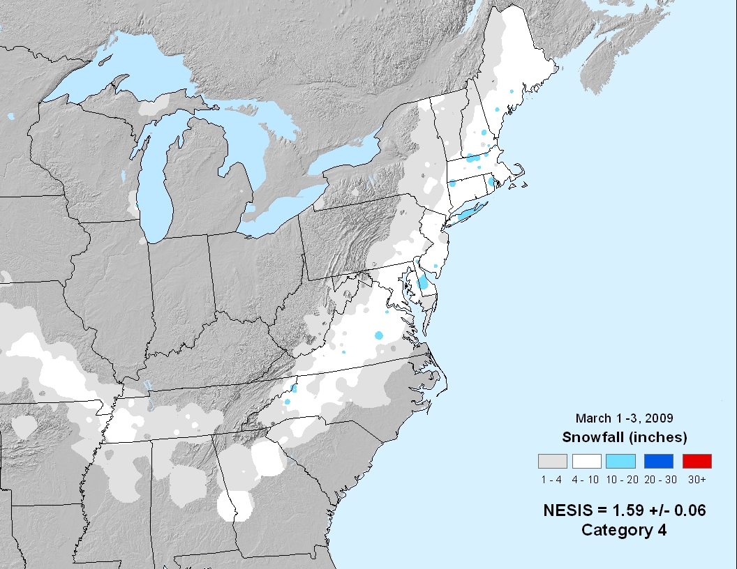
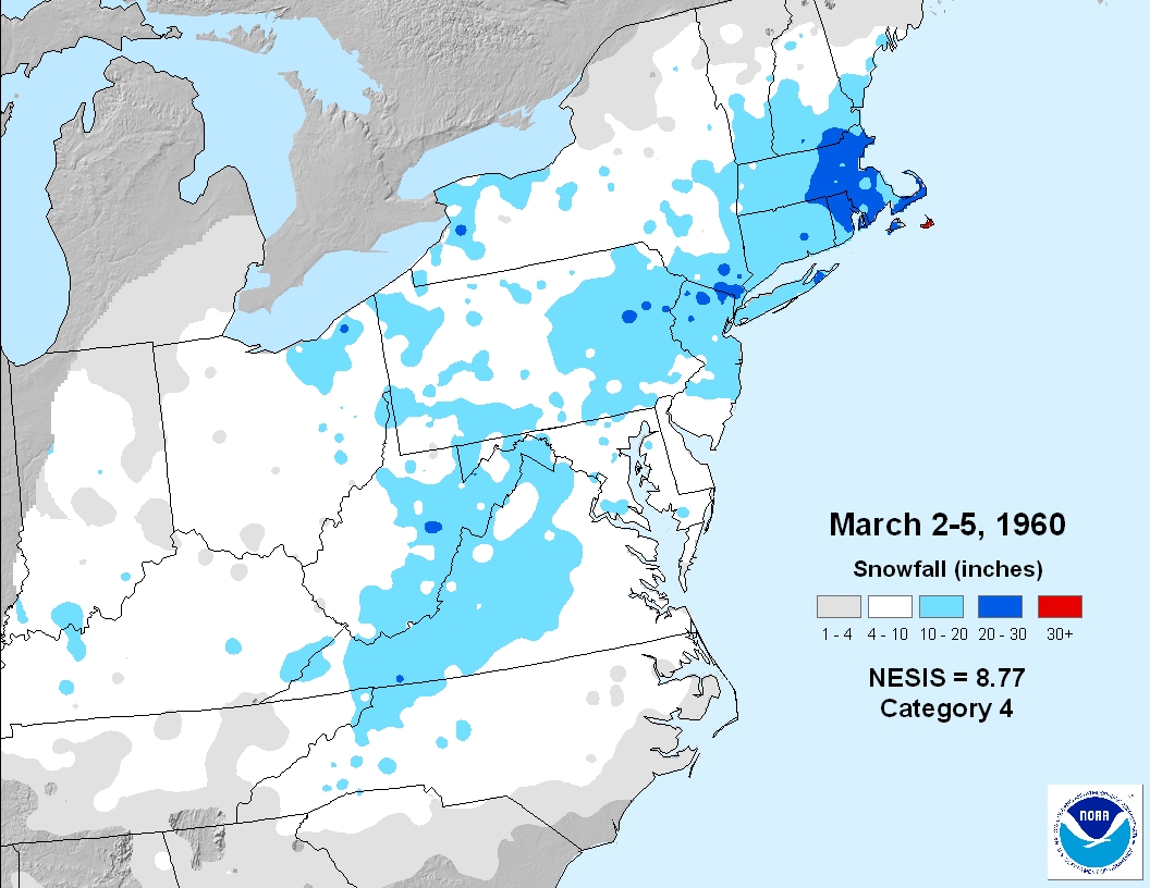
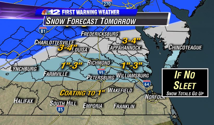
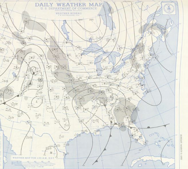
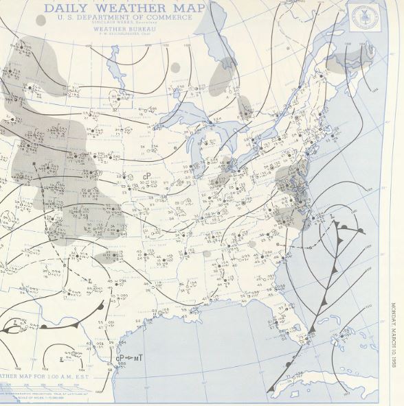
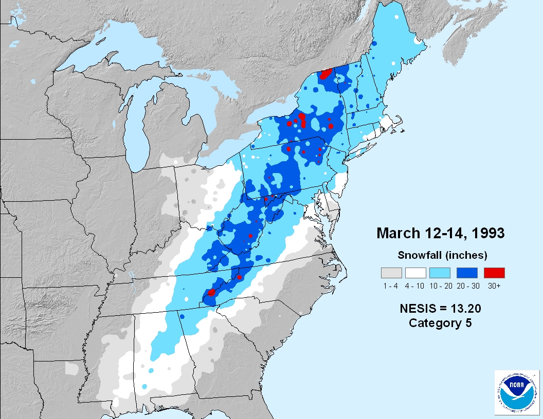
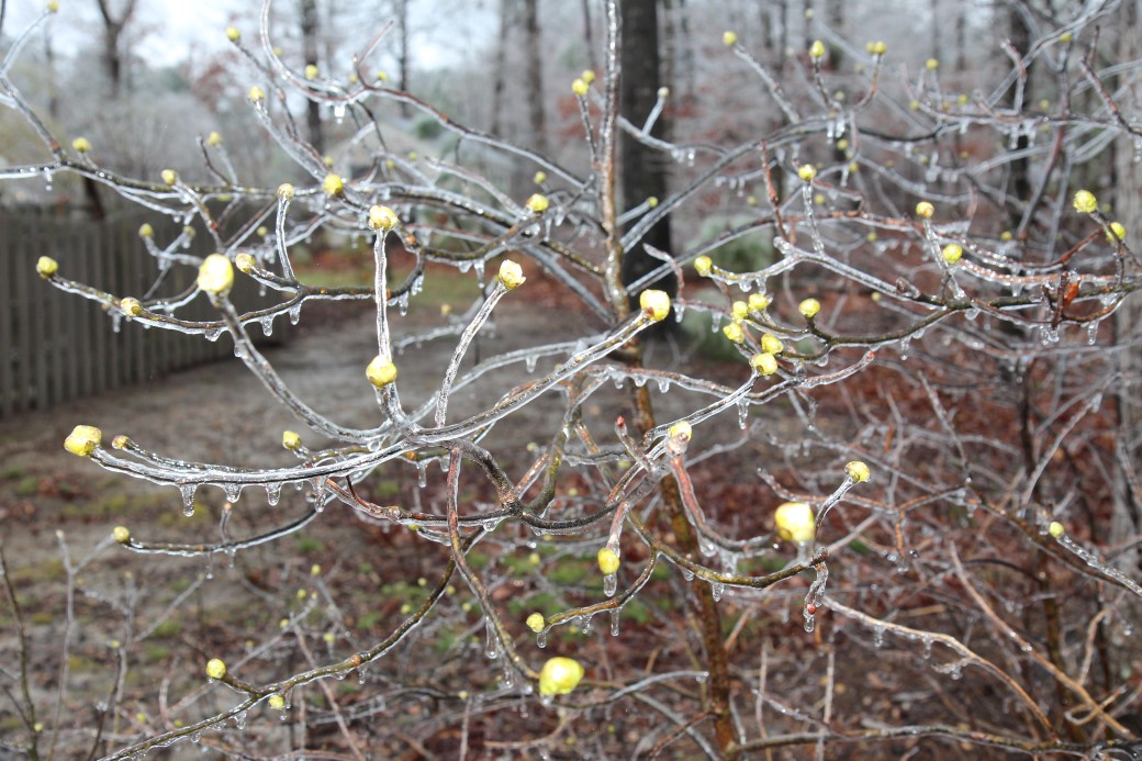
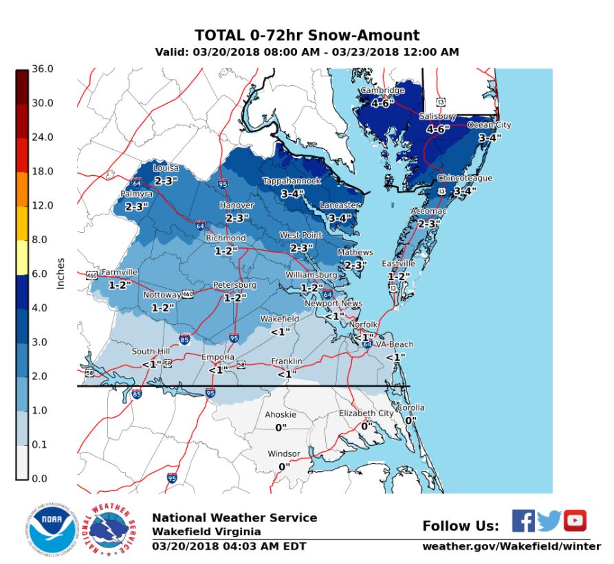
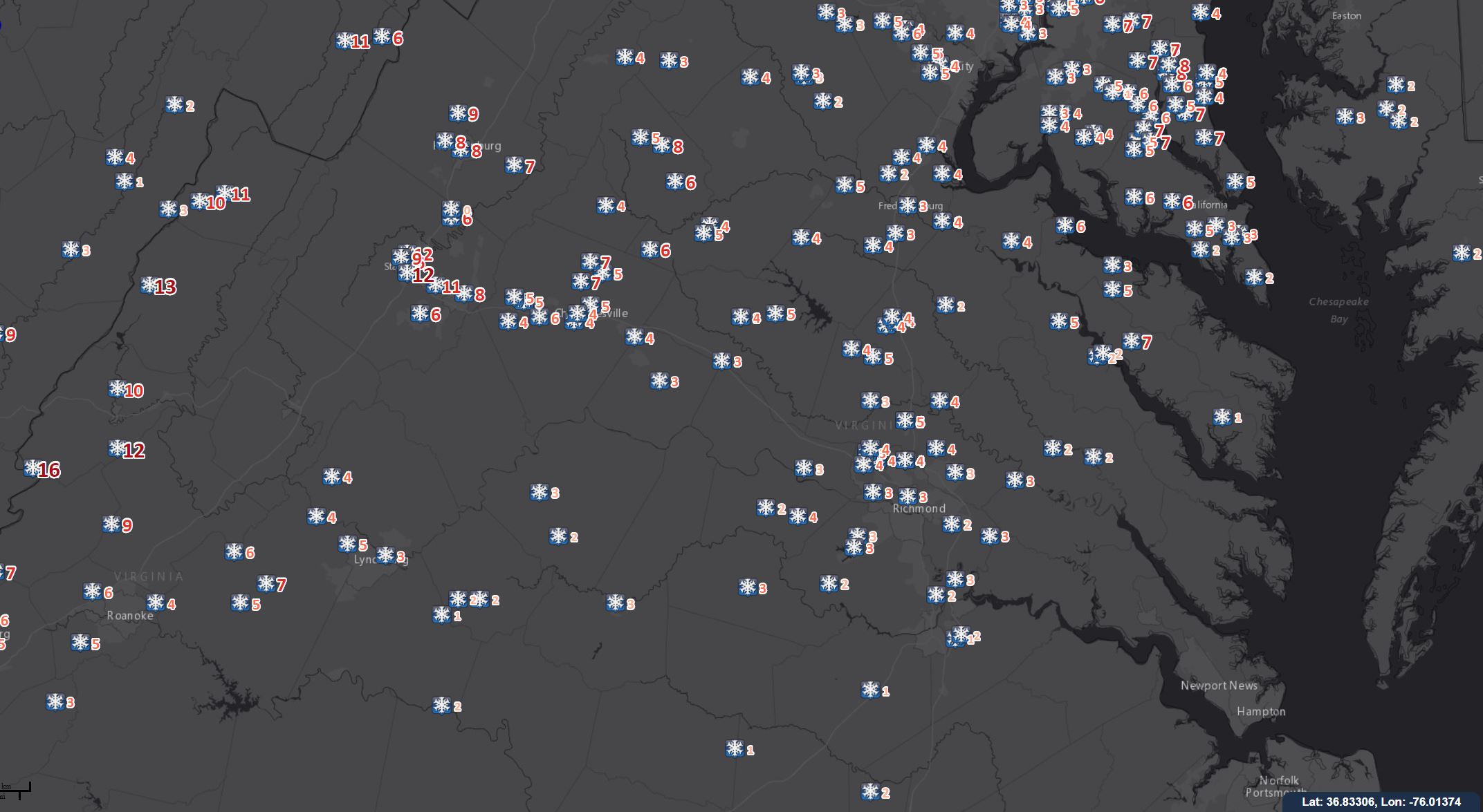