| WEST HENRICO CO. - SPRINGFIELD PARK, VA SNOWFALL FOR 2020-2021 WINTER'S TOTAL 11.7 Inches | |||||||
| BACK TO CURRENT SNOW TABLE | SNOWS OF PAST WINTERS | ||||||
| Days |
Snow Month |
Snow Day |
Total Snow Inches |
Rating Hourly Chart |
Time Lapse Movie |
Remarks | |
| 1 | Dec | 07th | 0.2 | Event 1 | Yes | This minor event was first predicted by the EURO model. The event started at 0600 as tiny pellets and a temperature of 34.5°F. The lowest temperature during the snow was 32.2°F around 0900 and snowfall intensity never reach even moderate. The ground and roads were so warm that the snow melted on contact. Some snow was on the grass for a while around 10AM as can be seen in the max. depth pic. but it could not be measured without a snowboard. The maximum measurement was taken at 10AM and by noon almost all the snow had melted. | |
| 2 | Dec | 10th | T | Event 2 | No | Very small snow pellets the size of a period fell from 0623 to 0628. Then rain started at 0755 and a little sleet that was mixed in occasionally. Between 1000 and 1145 a paper-thin layer of glaze formed on metal and colder objects along with pine needles and twigs. From 1145 to the time the precip ended at 2200 it was all rain a total of 1.09 inches. It was a major snowstorm in New England with a foot or more of snow in many places. | |
| 3 | Dec | 18th | T | Event 3 | No | From 0215 to 0550 Springfield Park had very light snow flurries that occurred and melted as they fell. The total precipitation was 0.01 inches of liquid. No measurable amounts were reported in Virginia. | |
| 4 | Dec | 25th | T | Event 4 | No | A brief light snow flurry occurred between 12:20 and 1232 that melted as it fell as the temperature was around 39°F. | |
| 5 | Jan | 24th | T | Event 5 | No | Snow flurries so light they weren't detected by the precip. sensor until 2010 and the snow melted shortly after falling. The lowest temp. was 36.2°F. | |
| 6 | Jan | 28th | 0.4 | Event 6 | No | The snow started at 0205 as a very light snow with temps. above freezing. The snow decreased the temp. to a min. of 30.1°F at 0445. The snow melted on roads as it fell was the ground was warm. The snow ended at 0520 and was well forecast as to the amount. | |
| 7 | Jan | 31st | 4.2 | Storm 1 | Mirror | The snow started at 0240 as an extremely light snow with a temps. of 32.8F. It was about 3 hours before measurable snow started. The street was white by 0540. The snow rate was moderate from 0640 to nearly a heavy rate at 0940 then heavy to 1010 when the snow tuned to sleet and a max. snow amt. of 4.2 inches was recorded. The sleet turned to freezing rain with 0.14 inches of liquid precip. before ending. | Snow board video |
| 8 | Feb | 02nd | 0.6 | Event 7 | No | Springfield Park had a little surprise this morning at 0430 as we stated getting light snow from the wraparound from the big storm in New England. A measurement was taken at 0830 and 0.6 inches was observed but both rain gauges had only 0.04 inches of moisture. The flurries lasted most of the morning but were very light and had little moisture in them. They melted as they fell after 0845 as the temperature increased. | |
| 9 | Feb | 03th | T | Event 8 | No | Between 0600 and 0710 some very light snow flurries. Not enough to measure. | |
| 10 | Feb | 07th | 1.9 | Storm 2 | Mirror | The rain started at 0030 and turned to rain and sleet at 0745 then to snow and sleet at 0810. The precip was all snow by 0820 and had 0.34 inches liquid at 0820. The most intense snowfall was between 0900 a 1000 when 1.1 inches occurred in one hour which is the most intense snowfall yet this winter. Again the temp. never fell below freezing and the snow was over by | Snow board |
| 11 | Feb | 11th-12th | 3.9 | Storm 2 | Snowboard | Rain started at 0935 and continued most of the day turning to a mix of rain and sleet at 1620. By 1720 the precip. was all sleet that turned to all snow at 1750. It was the first snow of the winter the temp. went below freezing which occurred around 2115. The snow fall rate to midnight was never more than 0.3 inches per hour. After midnight the heaviest snow rate was from 0250 to 0315. The snow was all but over by 0430 on the 12th. The storm total was 3.9 inches with 1.4 inches before midnight and after clearing the snowboards at midnight 2.5 additional snowfall occurred. The total liquid in the storm was 0.82 inches which also included about 0.24 of rain before turning to frozen precip. The computer server was down fom midnight to 0400 causing the sudden increase in snow in the movie above. | |
| 12 | Feb | 13th | T | Glaze | No | Freezing rain gave 0.15 inches of ice which was worst to the south and Dinwiddie County at one point had 98% of the county without power. The ice snow did minor damage to western Henrico County. | |
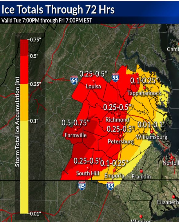
| 13 | Feb | 18th | 0.5 | Event 9 | Heavy sleet | In this storm the forecast was for 0.25 to 0.5 inches of ice. If we had 0.5 inches of ice Henrico Co. would have had a lot of power outages but luckily much of the precip. fell as sleet. In the sleet movie you can see the sleet impacts with the sleet surface on the deck hard enough it craters the sleet surface. Henrico Co. and the Dominion Energy escaped with minor damage. The max.ice measurement was 0.2 inches. | Ice Forecast |
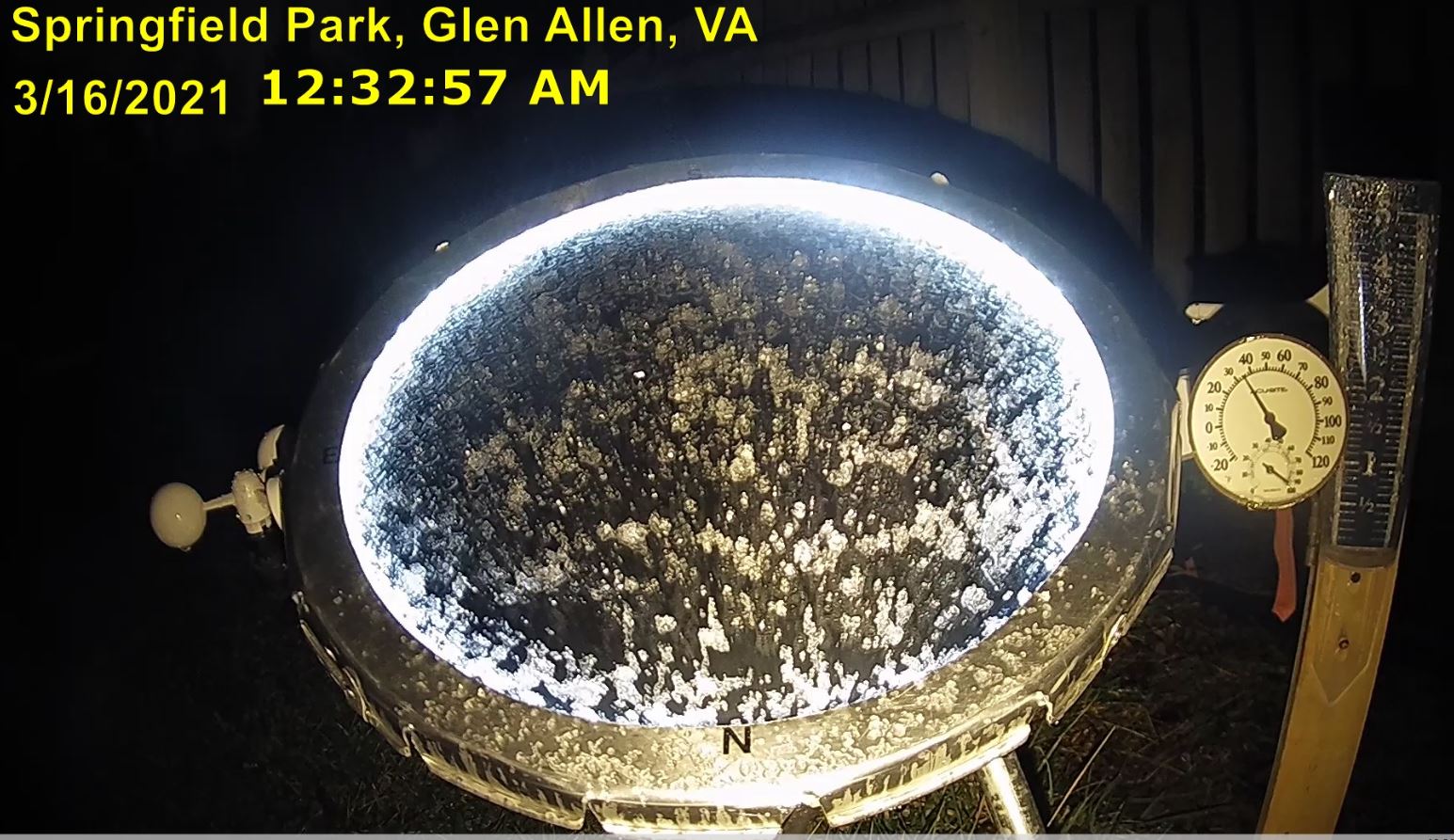
| 14 | Mar | 15th- 16th |
T | Event 10 Sleet Image |
No | A little sleet occurred before midnight on the 15th but the max amount of sleet as seen on the sky mirror was at 12:32 AM as the temperature fell to 36.4 degrees F. The ground was so warm the sleet melted pretty much as it fell. | |
| 15 | |||||||
| BACK TO LINKS | |||||||