The Day the Shenandoah Valley Stood Still
By Lowell L. Koontz
The early 1960's had several major snowstorms in the Shenandoah Valley: 9.3 inches of new snow on March 3, 1960; 10.3 inches on March 16, 1960; 7.5 inches on January 19, 1961; 8.5 inches on February 3, 1961; and 12 inches on February 8, 1961 at the east Rockingham weather station, four miles NE of Elkton, VA. The total snowfall for 1961 was 48.5 inches and in 1962 it was 60.8 inches. On Christmas Day in 1962, 5.8 inches of new snow fell yielding a 8.3 inch total accumulation which was the most on the ground for any December 25th since 1909.
As a junior in high school, during the late winter of 1962 the snowstorm of March 5th, 6th, and 7th was a storm to be remembered. This snow started at 7:00 A.M. on March 5, 1962 as a snow shower on Massanutten Mountain and then a snow shower on the Blue Ridge by 7:15 A.M. By 7:30 A.M., a light snow had started in east Rockingham County on the border of Page County where my weather station was located but this light snow was intermittent until about noon when it dramatically increased in intensity. The Weather Service issued a snowfall forecast of 8 inches and school was cancelled at 2:00 P.M. "Apparently all the forecasters, both Weather Bureau and private, were taken in some degree by surprise, since the storm did not conform to the usual pattern for a coastal disturbance (Stewart 1962). "
When I got home from school at 2:35 P.M. we already had 8 inches of snow. At 10:00 P.M., I recorded the last measurement for the night. The snow continued to fall with 14 inches on the ground, which I reported to the Harrisonburg newspaper the "Daily News Record." It was already the most snow I had ever recorded in a 24-hour period since I began keeping weather records in 1956. I remember the snowfall had decreased in intensity at the time of my last measurement and the storm appeared to be diminishing.
The next morning I awoke to the greatest weather surprise of my lifetime. I was the first one up in the morning to check on the snow and I would often look out the second floor bedroom window which overlooked the first floor roof since it was an easy way to see the snowfall depth. The shade was about one-fourth of the way up and all I saw was white. I raised it about halfway and still only white. I could not believe it. I let the shade go almost all the way to the top of the window and could finally see the top of the snow. I couldn't believe what I was seeing. Had snow just blown off the roof above? I woke everyone else up by shouting the astonishing news that the snow was at least halfway up to the top of the windows. I doubt that I have ever dressed any quicker since I couldn't wait to check the depth of the snow. I found in the midst of a heavy snowfall we had the incredible depth of 24 inches and still the snow continued to come down at a furious rate. The wind was blowing at 20 to 30 mph causing drifting of the snow. The creek road was warm enough that it only had 18 inches but there was no sign of any tire tracks. On March 6th, 1962, the Shenandoah Valley stood still. After hearing the news, I found on US Route 11 that stretches west of Harrisonburg, there was a two mile long section of road that was dotted with stranded cars. Almost everything was closed. On the NBC national news they said the Shenandoah Valley was having the worst snowstorm in more than 60 years. At 7:30 A.M. exactly 24 hours after the snow had started we had 25.5 inches. The most snow ever recorded at Dale Enterprise just west of Harrisonburg in 24 hours was 24 inches on December 20, 1880. I later learned that the western part of Rockingham County, where Dale Enterprise is located, received less snow than the eastern half but they tied their snowfall record for any 24-hour period.
By 9:30 A.M. there was 27 inches of snow at my station. The snow almost completely covered the legs of my weather shelter. It was extremely difficult to walk through since you would sink so deep in the snow that the snow came to the top of your legs. Our car was nearly immersed in snow causing it to look like a bump and snow was halfway to the top of our gates and fences. The electricity was out in many areas. A Greyhound bus was stuck on US Route 11 but people around the area took the passengers into their houses. No traffic had moved on US 11 for 8 hours. It continued snowing until noon but the temperature rose to 36 degrees Fahrenheit and the snow settled under its own weight to 26.5 inches by noon. The snow then turned to a very light rain and drizzle by 1:30 P.M. and measured 26 inches. Luray, Virginia reported a maximum of 34 inches, while the radio station WSVA had 22 inches. We tried to get to the back farm to feed cattle on a WD-45 Allis-Chalmer tractor but the snow was too deep for it. I managed to get the tractor about fifty feet out of the shed before it became obvious that the snow's power outmatched the tractor's traction. My Dad told me to pull it back in the shed as it wasn't going to be of any help.
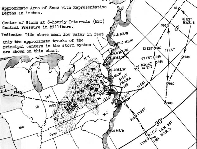
The barometer dropped to a minimum of 29.21 inches of mercury at 8:00 A.M. on Tuesday, March 6,1962. The track of the East Coast Storm of March 6-9, 1962 is shown on the map
It was a wet snow containing 2.80 inches of water. The only way to travel through this snowfall was either on foot or riding a bulldozer. Helicopters were required to take medicine to some people in need. In the afternoon the drizzle turned back to snow and by 5:30 P.M. it was snowing moderately again and by 10 P.M. we had 4 inches of new snow but only 28 inches on the ground.
On March 7, 1962 at 10 A.M. Mr. Billy Lam, a neighbor down the creek, plowed the creek road with a bulldozer. No one had been able to travel the creek road, Route 609, for 34 hours. It was also the first time in ten years that the mail wasn't delivered. I walked the half-mile to the back farm to feed the cattle. With the added snow of last night, we had 33.5 inches total snowfall for the three-day period, March 5th-7th. The total water content melted was 3.10 inches but the most on the ground at any time was 30 inches at 6:30 A.M. due to settling. (Dale Enterprise recorded 27 inches.) It took almost four hours to feed and make the round trip on foot to the back farm instead of an estimated 40 minutes without adverse conditions. The snow had drifted over the fences in several areas and I was able to step over the gate going into the back barn. We had a maximum temperature of 46 degrees on March 7th and had only 24 inches of snow by sunset.
On March 8th, daylight broke under a crystal blue sky. The first rays of the morning sun hitting Massanutten Mountain under its thick blanket of snow reflected the Sun's golden rays making for a beautiful scenic view. The minimum temperature of one degree below zero F at my station on March 8th chilled the air enough to produce a hoarfrost in the low areas near the creek and with the Sun's first rays made the snow's surface sparkle like diamonds in the morning light.
Rescue teams used a helicopter to get one person who needed medical attention out of the mountains just below Big Meadows of the Skyline Drive. Big Meadows recorded 42 inches of snow in this storm, which was the official high single storm record snowfall for the state of Virginia until the storm of January 6-7, 1996 when 48 inches fell in one storm at Big Meadows. The greatest 24-hour snowfall record for Virginia is still held by the March 1962 storm. On March 6th 1962, Big Meadows recorded 33 inches (Hux 1999). This storm will be remembered by many as one of the historical snows of the Shenandoah Valley. The last trace of this great snowstorm had completely melted by March 29th.
The storm on March 7th, 1962 was known as the Ash Wednesday Storm along the East Coast and hit some areas with wind gusts of hurricane force. The Chesapeake Lightship recorded a gust of 80-mph from the NNE at 3:57 AM and Block Island, RI recorded an 84-mph gust from the NE at 10:55 on March 6th. The Chesapeake Lightship of the Coast Guard, 17 miles east of Cape Henry Lighthouse, was damaged by a 50 foot wave early on March 7th and was forced to leave the station with sustained winds above hurricane force. The storm affected areas from Charleston to Boston for a 65-hour period beginning on March 6, 1962 killing more than forty persons, 340 received major injuries and 912 minor injuries. There was one-quarter billion dollars property damage with over 1,793 dwellings destroyed and 2,189 sustained major damage and 14,593 minor damage (Cooperman and Rosendal 1962). "The effects of the storm even reached northern Florida where swells greater than 12 seconds was a record observed for the first time. The storm persisted through four to five high tide cycles, a situation, which never before had been recorded. Furthermore, in a hurricane the high tides usually precede the highest winds whereas in a steady-state type northeast storm the highest winds usually precede, and may last through, the highest tides (Bretschneider 1964)."
The principal feature of the weather map on the morning of March 5, 1962 was a large high pressure area of great magnitude (31.30 inches of mercury) over northeastern Canada and a surface low (29.77 inches of mercury) over the Ohio Valley which was tracking SE but losing strength. A poorly formed low pressure that formed to the NE of the Bahama Islands on an old polar front moved into the area off Cape Hatteras. The residual vorticity of the Ohio low and the baroclinic effect of the area caused the low pressure to rapidly gain strength as the high pressure blocked its forward progress. Thus a low pressure with a long west-to-east axis extending from close to Hatteras east-northeastward some 1,000 miles to near 40°N latitude and a very strong pressure gradient was set up giving very strong NE winds across an extremely long fetch (Stewart 1962). Note the loop in the track off the East Coast of VA between 1900 hrs EST March 5 th and 1900 hrs EST March 6th.
Our heaviest snow occurred between midnight and 700 A.M. EST in the Shenandoah Valley during the time of this tracking off the Virginia coast (U.S. Department of Commerce Weather Bureau Library 1962).
One of the strongest cases of blocking ever observed on a mean circulation pattern for any March was observed this year. The sea level circulation for March 1962 shows a large high pressure area that dominated North America and the polar regions with pressures as much as 22mb above normal in Greenland. In the Atlantic a deep Low, 10 degrees south of its normal position, was a corollary feature of the circulation. This extreme blocking assisted the development of the "Great Atlantic Coast Storm" of 5-9 March, one of the most destructive extra tropical cyclones to hit the United States coastline. The storm intensified in the western Atlantic, but its motion was slowed by strong high pressure to the north. Thus the storm created a strong easterly flow across the North Atlantic where the flow is normally from the west. The long fetch and persistence of this circulation and gale force winds from southern New England to Florida reinforced spring tides to create mountainous seas and much flooding and erosion along the coast. Heavy precipitation accompanied the development stage of the storm over the Middle Atlantic Coast with inland sections of Virginia and Maryland receiving as much as three feet of snow (Andrews 1963).
The blocking of the mean circulation pattern prolonged the storm for more than two days. Twice each 29.5 day lunar phase cycle, at new moon and full moon, the Sun, Earth and Moon are nearly aligned in space which is called syzygy (sizz ah gee). During syzygy both the gravity of the Sun and Moon work together to pull higher than average high tides or spring tides but there was more than this on March 6th as the Moon was also at perigee. Perigee is the point in the Moon's orbit where the Moon makes its closest approach to the Earth.
The Moon's orbit isn't a circle but an ellipse and can approach as close as 221,428 miles compared to the average distance of 238,855 miles. Perigee distances vary and the closer the perigee distances the stronger is the moon's gravity and the higher the high tide (often called a spring tide.)
This storm hit at a time when there was only 31 minutes separating the syzygy alignment and perigee. March 8, 1993 was another of these dates and was near the time of the "Storm of the Century" on March 12-13, 1993. Also, syzygy alignment and perigee occurred on February 7, 1997 and on February 8th we recorded a 5.8 inch snow which was the largest snow for a three-year period. The last date when both syzygy and perigee occur together was December 22, 1999.
References
Andrews, James F. 1963. "The Circulation and Weather of 1962." Weatherwise. Vol.
16, Number 1. p. 11.
Bretschneider, Charles L. 1964. The Ash Wednesday East Coast Storm, March 5-8,
1962: A Hindcast of Events, Causes, and Effects. American Society of Civil
Engineers, New York, NY. p. 617.
Cooperman, A. I. and Rosendal, H. E. 1962. Mariners Weather Log. Vol. 6, Number 3.
p. 79, 83-84.
Hux, Dustin. 1999.
VA State Climatology Office. Clark Hall. The University of Virginia.Charlottesville, VA.
Stewart, John Q. 1962. "The Great Atlantic Coast Tides of 5-8 March 1962."
Weatherwise. pp. 117-118.
U.S. Department of Commerce Weather Bureau Library. 1962. East Coast Storm March 5-9, 1962.
Williams, Jack. 1992. The Weather Book, Vintage Books, New York. pp. 56-57.